 World Journal of Engineering and Technology, 2014, 2, 71-77 Published Online September 2014 in SciRes. http://www.scirp.org/journal/wjet http://dx.doi.org/10.4236/wjet.2014.23B011 How to cite this paper: Chen, M.-Y. and Chow, I-C. (2014) Mitigation Strategies of Land Use for Zengwen Reservoir and Its Catchment: Post-Disaster of Typhoon Morakot. World Journal of Engineering and Technology, 2, 71-77. http://dx.doi.org/10.4236/wjet.2014.23B011 Mitigation Strategies of Land Use for Zengwen Reservoir and Its Catchment: Post-Disaster of Typhoon Morakot Miao-Yun Chen, I-Chang Chow Feng Chia University, Ph.D. Program in Civil and Hydraulic Engineering, Taichung, Taiwan Email: chowic@fcu.edu.tw Received Ju ly 2014 Abstract Mitigation and adaptation have become two main strategies that governments around the world are focusing on in response to the threat of global climate change. In August 2009, Typhoon Mo- rakot heavily damaged the central and southern parts of Taiwan, causing irreversible damage to the environment, especially in the mountain areas. In this study, the goal is to attain sustainable reservoir management, thus comprehensive storm water management is used to develop mitiga- tion strategies. Overlay-map methods of GIS, along with vulnerability analysis and land use sus- tainability analysis, are used to map out optimal land use patterns containing development poten- tials, growth limits, and suitability concerns that aim to reduce the impact of human development on the ecological environment. Finally, the mitigation strategies proposed by this study for the land use of Zengwen Reservoir and its catchment will be implement shortly. Keywords Global Climate Change, Environment Vulnerability, Sensitive Area, Suitability Analysi s, Mitigation, Adapta ti on, Map Overlay, Comprehensive Storm Water Management, Catchment 1. Introduction With the increasing consequences of global climate change (GCC) and the greenhouse effect, how humans adapt to these consequences, continue their lives, adjust in land use, social-economic developm ent, and achieve a sta- ble and bala nced natura l system are a s equall y important a s mitigation. For this reaso n, both mitigatio n and adap - tation have been major areas of focus in the government’s response to the threat of climate change [1]. Central and southern Taiwan was badly hit by Typhoon Morakot in August 2009, which caused not only great loss of lives and properties, but also irreversible damage to the mountainous lands and the environment. The present study uses comprehensive storm water management as the core mitigation strategy. Through stable re- servoir water supply recover y, water conservation, catchment protection, and adjustment of land use for existing livi ng and pr oductio n space, as wel l as analyz ing the v ulnera bility ind icator [2] [3] and land suitabil ity anal ysis [4]-[6], the study exp lo res the impact of current land use on water quality, quantity and water supply. In addition,  M.-Y. Chen, I-C. Chow the study also suggests land use adjustments [7] to reduce the impact of human development on the ecological environment of catchment area and eventually achieve the goal of sustainable reservoir management. 2. Trend of Upstream Catchment Governance in Response to GCC 2.1. Impact and Response to GCC GCC increases the probability and intensity of extreme weather events, and causes more frequent floods and hillside disasters triggered by typhoons and rainstorms. Taiwan is vulnerable to typhoons and storms [8]. Its to - pographical and geological conditions make hillside disasters such as debris avalanche, mudslide, and landslide more freque nt in T ai wan. Prob lems suc h as o veruse , misuse of land resources caused by improper development in the past and dwindling permeable and storage area will cause severe damage when natural disasters occur. Furthermore, considerable destruction to infrastructure caused by the disasters will increase the difficulty of post-disaster recovery and increase the extent of da mage to life and property [8]. Therefore, in response to extreme climate change, the goal of this study is to develop the response to envi- ronment changes for sustainable life and industrial development through the adjustment between social economy and land use based on the principles of mitigation and adaptation [1]. As for the planning tools for land use con- trol and development, this study gives priority to public life and property safety and re-reviews the ra tionality of catchment development in order to achieve the goal of land conservation and sustainable develop ment [7]. 2.2. Background of Zengwen Reservoir Catchment and Disaster Damage 2.2.1. Land Use for the Catchment Zengwen Reser voir, lo cated upstrea m of the Zengwun River, was co mpleted in 19 73 to regulate water for irriga- tion in the Chiana n Pla in, a s well a s for po wer ge neratio n, flood pre vention and tourism. I ts total cap acit y is 7 00 million cubic meters and water surface area is 17 square kilometers. Its catchment area is approximately 70,029 hectares. Its land consists of forest land, agricultural land, and construction land, each taking up about 53,761 hectares (76.77%), 8928 hectares (12.75%) and 376 hectares (0.54%) respectively. The Zengwe n Reservoir catchment is loc ated in middle-high altit ude area, with the majorit y of slope s classi - fied as steep. Changes in rainfall patterns over recent years, coupled with mismanagement over catch ment la nd use and development, resulted in multiple landslides and collapses. In addition, water from the channel that flows into the catch ment area o ften contain s a lot of sediment and alluviu m, which poses a serious threat to the reservoir’s sustainable management. Therefore, non-engineering management [7] methods should be employed for adjustment and planning on catchment soil conservation and land use to ensure land conservation, stable water suppl y, and disas t er prevention and mitigation. 2.2.2. D am age Caused by Typhoon Morakot From August 6 to 10, 2009, central and southern Taiwan had been badly hit by the prolonged heavy rains in- duced by Typhoon Morakot, which left 699 dead or missing, 1622 houses damaged, 1.2 billion cubic meters of hillside deb ris collapsed, 30 meters of silt accumulated at sediment dams, 30 meters o f silt accumulate d at river valley and 76,535 hectares flooded in Taiwan [8] [9]. The rainfall at 24, 48 and 72 hours during the period hit record-breaking heights 1623, 2361 and 2748 millimeters respectively and the 24 and 48 hours of rainfalls also approached world-record amounts of 1825 and 2467 millimeters [10]. The region that witnessed the most rain- fall was the Alishan in Chiayi County, which is the upstream catchment for Zengwen, Nanhua a nd Wushantou Reservoirs. Landslides in the catchment area brought a large amount of sand and earth to the reservoirs, se- rio us ly affect ing the wa ter supply in southe rn Taiwan. According to the Water Resources Agency [11], the collapse rate of catchment before the typhoon was 1.43%, and the number tripled to 5.23% after it, with a dramatic increase in collapse area to 2277 hectares. The Nanhua Reservoir is mainly on forest land (approximately 91%); while the Zengwen Reservoir is on forest land (48%), hillside (21%), main street and general roads (24%), resulting in significant increase in reservoir sedimentation rate, decrease in reservoir capacity, and thus water supply shortage. 2.3. Upstream Catchment Governance Trend To ensure the sensitive nature of the upstream catchment aquatic environment and the reservoir operational 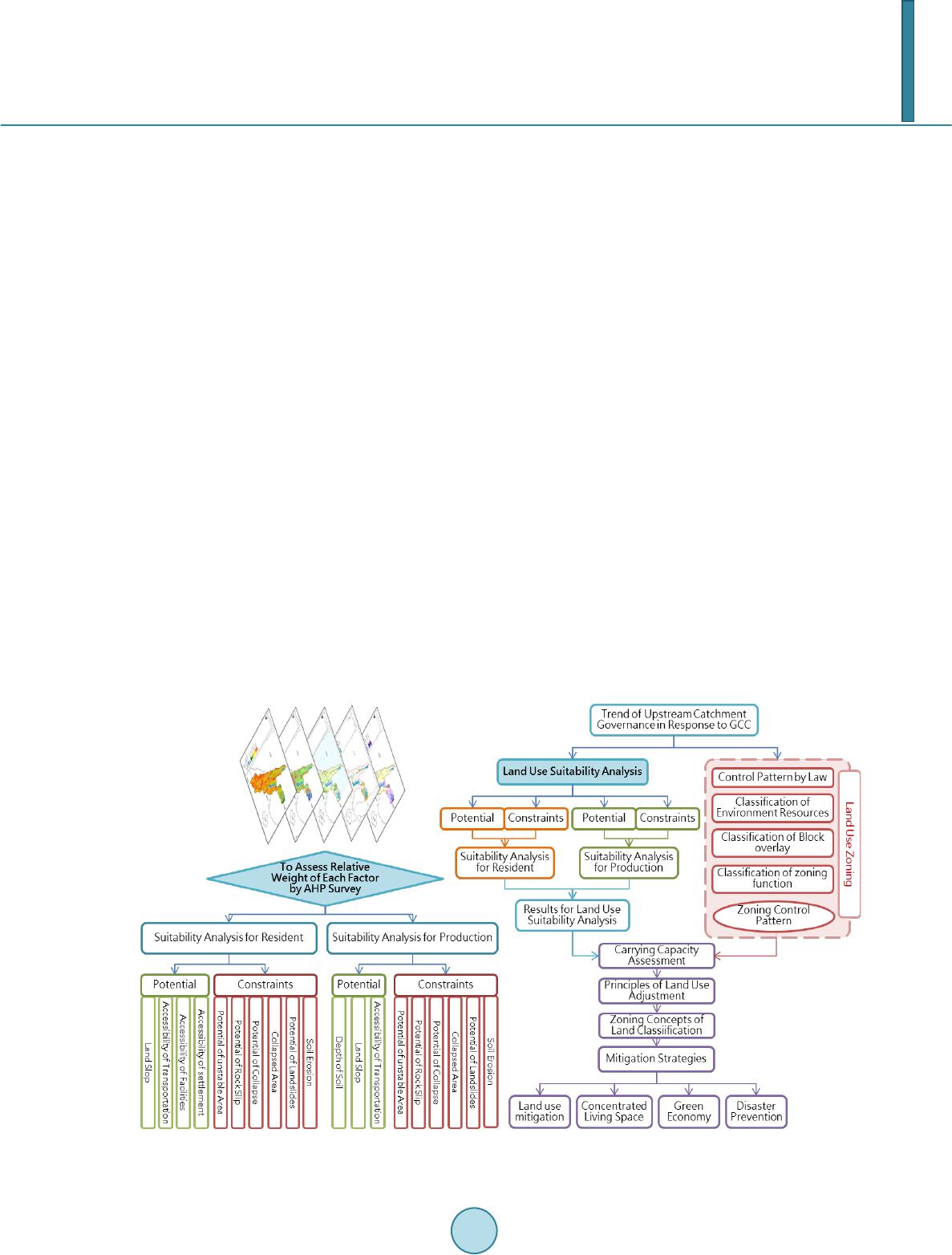 M.-Y. Chen, I-C. Chow functions, comprehensive storm water management serves as the core of mitigation strategies in this study, which sets up classification rules for land conservation, protection of water resources, and disaster prevention. Thi s study ai ms to mai ntain the ecologi cal envir onme nt [12] [13] and to ensure the safety of people’s lives a nd property and water supply by restricting land use in the catchment area for living and industrial purposes. Its governance princi ples includ e [14]: ● Keeping the ca t chment and down stream rivers from po llutio n and the impoundment areas from des t ruction. ● Prohibiting or restricting development and utilization within certain range of potential disaster areas, consi- dering environmentally sensitive features, and making appropriate adjustment to land classification accord- ing to the current devel opment. ● Planning and controlling the land use for domestic and industrial purposes. ● Regulating and reviewing land use in accordance with the ecological planning principles of avoidance and minimization [7]. 3. Mitigation Strategies 3.1. Overall Land Use Mitigation The deterioration o f the environ ment and occurre nce of na tural disasters in T aiwan over the last decad e has high- lighted the urgent need for integration between land conservation and national security. In response to global cli mate cha nge a nd fo r en viro n mental s ustainab ility, a t pre sent, the gover n ment is acti vely p ro moting le gislatio n on national la nd planning to act as the basis for land safety and conservation [1] [15] [16]. Under the concept of safety, sustainability, and coexistence, development in areas for resource conservation and of potential hazards should be limited [17] [8] according to the eco-planning concepts such as avoidance, minimization, and com- pensation [7] to reduce conflicts of land use and occurrence of disasters and to promote land resources and en- vironmental sustainability. The research framework is a s shown i n Figure 1. This stud y, usin g map o verla y analysi s [5] [6 ] , a ssesses the spatial distrib ution of the most suitable la nd use patterns within the ca tchment through en viron mental sensitivity analysis and suitability analysis, and then explores the direction of land use classification review with overlay zoning after cross-check i ng and adjusti ng current land use agains t existing land use regula tions in Table 1. Figure 1 . Research framework.  M.-Y. Chen, I-C. Chow Table 1. Land use adjustment for the Zengwen reservoir catchment with overlay zoning comparison with environmental sensitivity and suitability analysis. Environment Sensitive Area Results for Land Use Suita bility A naly sis Current Land Use Land Use after Adjustment Ite m Area (ha.) Item Area (ha.) Item Area (ha.) Item Area (ha.) Regulating Principles Core Ar ea 67,959 Suitabl e f o r Residen tial and Agriculture 2095 Agriculture 505 National Conservation Ar ea I 67,959 Prohibit Any Development Residen tial 31 Others 1560 Suitabl e f o r Agriculture 3367 Agriculture 634 Residen tial 50 Others 2683 None of above 62,496 Agriculture 6460 Residen tial 349 Others 55,687 Buffer Ar ea 1049 Suitabl e f o r Residen tial and Agriculture 550 Agriculture 413 Agric ultura l Are a 413 Agriculture Use Only Residen tial 17 Urban-Rural Ar ea 17 Low Density Development Others 120 National Conservation Ar ea I I 120 Conditional Development Suitabl e f o r Agriculture 262 Agriculture 168 Agric ultura l Are a 179 Agriculture Use Only Residen tial 11 Others 83 National Conservation Ar ea I I 320 Conditional Development None of above 237 Agriculture 110 Residen tial 5 Others 122 None 1021 Suitabl e f o r Residen tial and Agriculture 584 Agriculture 324 Agricultur al Are a or Urban-Rural Ar ea 324 Agriculture Use Only or Low Density Development Residen tial 31 Urban-Rural Ar ea 31 Low Density Development Others 229 Agricul tural A rea or Urban-Rural Ar ea 229 Agriculture Use Only or Low Density Development Suitabl e f o r Agriculture 181 Agriculture 49 Agr icultur al A rea 181 Agriculture Use Only Residen tial 12 Others 120 None of above 257 Agriculture 85 National Conservation Ar ea I I 256 Conditional Development Residen tial 18 Others 153 Source: Compiled by the researcher. 3.2. Limited Concentrated Land Use for Living Space Limited concentrated land use for living space to slow the impact of extreme weather, existing communities and settlements in the catchment are scattered. Due to the effects of extreme climate in recent years, landslides in- duced by almost every heavy rainfall pose a serious threat to the residents living in remote areas, and also in- crease the public and private investment in emergency evacuation, relief, and rehabilitation year by year. If li- mited government resources can be pooled to achieve maximum efficiency in public infrastructure, it can im-  M.-Y. Chen, I-C. Chow prove the quality of life of the residents, and more importantly, increase the efficiency of emergency assistance and disaster response [ 17]. The objective of the plan for the settlements and other land use should be to promote sustainable environ- mental develop ment a nd to ensure t he safety of the hill tribe s, and the imple mentation strategies relate d to land restoration should be put forward [18]. The present study reviews and controls the distribution of existing set- tlements through comparison bet wee n the resul ts of la nd suit abilit y ana lysis and the cur rent set tlement use. I f a settlement is in the natio nal co nser vation area or its use is aga inst the pr ovision s of relevant la ws and regulatio ns, its inhabitant s must migrate to another area suitable for living in so as to reduce the occurrence of disas ters a nd over-exploitation. 3.3. Zero Impact on Economic Development to Shape the Green Economy Industry The production activities within the catchment area are dominated by agriculture and tourism [19]. However, the steep and fra gile terrain ma kes it unsuitab le for d evelop ment, this stud y consider the envir onmental carr ying ca- pacity [4] [6] [7] to guide industrial restructuring and reduce environmental hazards within the catchment area. This study discusses overuse, misuse over-regulation for the different land use patterns within the catchment area through the a nalysis of land ca rrying capacit y, suitabili ty and vulnerab ility to assess t he spatial distrib ution of optimal land-use pattern within the scope, and takes zero impact [12] as the land development principle to achieve sustainable industrial and environmental development. 3.3.1. Mitigation Strategies for Agriculture The land use and planning in the catchment area are closely related to river water quality, downstream water safety, disaster prevention, and other functions, so efforts should be made against violations such as land over- use and misuse within the ran ge to se e k ra tional utiliza tion of upstream land. ● Progressive policies for land overuse, mis use should be adopted to gradually return farmland to forest. Land suitable for farming should be designated for pastoral reserves for farmers. ● Regulate and control land conservation and utilization. Redevelop the control rules for the improper use of agricultural land and sensitive land, and adjust its zoning according to the overuse processing or relocation compensation method. ● Designate appropriate production space and improve dry farmland production environment, counsel local farmers to grow crops in line with regional characteristics in the range, pro mote agricultural land and water conservation measures where appropriate, emphasize the hillside conservation concept, plant trees, and strengthen forest water conservation to reduce soil erosion and stabilize water supply in the catchment area. 3.3.2. Mitigation Strategies for Tourism Most tourism resources in the catchment area are raw natural resources, unique and fragile, and priority should be given to ecotourism based on low level development and sustainable management according to their proper- ties. Create new features by integrating local characteristic industries to develop sustainable ecotourism and promote sustainable development and environmental conservation. ● Follow the land conservation goals and adjust to the self-sufficiency green economic development model that interacts with nature based on changes in natural environment and ecological resources. ● According to the needs of different tour groups and local characteristics, design thematic recreation tours and build a local food industry chain. ● In light of the principle of sustainable development, implement local featured tours and establish relevant regulator y rules to a vo id the destr uction of local e nvironme ntal resource s by foreign to urists. ● Define the maximum carrying capacities to avoid over-development and implement overall development and quota control through the combination of tourism resources, local industry and road network. 3.4. Strengthen the Planning Strategies for Disaster Prevention and Refuge Space The common disasters induced by steep slopes in the catchment are mudslides and landslides. The terrain and environmental factors contribute to the lack of spacious escaping space, shelter, and a short escape route [17]. This stud y prop oses to ta ke local schoo ls, libr aries, c hurche s, po lice and fire units, a nd med ical facili ties for dis - aster prevention and rescue and p lan emergency shelters and rescue routes by int egr ating transp ort systems.  M.-Y. Chen, I-C. Chow ● Disaster prevention network system: Take Provincial arter y road No. 3 as the core route of the emergency access system, supplemented by county main road as aid deliver y chan nels, i ndustria l roa d s as fire exits, a nd agricultural roads as emergency evacuation passages, to construct the regional disaster prevention network system [20]. ● Shelter: According to the time sequence of disasters and corresponding behaviors, the shelter is divided into four levels. According to regional distance, potential scope of the disaster, shelter, medical care, supplies (including helicopter landing ground), and fire and police strongholds, a living shelter is set up based on 3 to 6 villages under the principle of proximity, totaling 10, as the minimum unit for disaster prevention. 4. Conclusion Post-disaster reconstruction is a long and complex project, which includes: implementation of special budget, home rebuilding, infrastructure construction, industrial reconstruction, and prolonged reconstruction. The miti- gation of land use is the basis of post-disaster reconstruction. The mitigation strategies proposed by this study for the land use of Zengwen Reservoir and its catchment are: 1) National Conservation Area I, about 67,959 hectares, prohibited from development or maintaining the status quo and taking progressive policies to return land to forest; 2) National Conservation Area II, about 696 hectares, allowing licensed development or limited development depending on the conditions of environmentally sensitive; 3) Urban-rural Development Area, about 601 hectares, consisting of 553 hectares also in Agricultural Development Area, which suitable for agri- culture use only or low density development and can be developed moderately without destroying original eco- logical envir onment and landscape resources; 4) Agricultural development area, about 773 hectares, maintained basically for agricultural use, and adjusted for other purposes by local governments as a result of special needs. Acknowledgements The authors express sincere thanks to reviewers and ed itors for their insig htful co mments and co nstructive su g- gestio ns to l eve l up the qual ity o f t his p ape r. F urthe r more, t his st ud y is a pa rt o f the re sea rc h res ult o n “T he Ra - tiona l Land U se Plan ning by Suitabil ity Ana lysis a nd Land Use Adjust ment wit hin the Catchment o f the Zen g- wen, Nanhua a nd Wushantou Rese rvoirs”, which wa s commissio ned by the Construc t ion and Plannin g Agency. References [1] National Development Council (2012) Guideline of National Adaption Policy for Global Climate Change. [2] Lee, C.-M. and Chen, C.-C. (2010) Vulnerability Indicator: Building and Assessment in Taiwan. City and Planning, 37. [3] Wu, J.-Y. and Huang, Y.-S. (2011) The Establishment of Vulnerability Evaluation Indexes: The Case of Shueili Township, Nantou, Taiwan. City and Planning, 38. [4] Berke, P.R., Godschalk, D.R., Kaiser , E.J. and Rodri gu ez, D.A. (2006) Urban Land Use Planning. 5th Edition, Univer- sity of Illinois Press. [5] Maantay, J. and Z iegler, J. (2006) GIS for the Urban Environment. ESRI Press. [6] McHar g, I.K. (1971) Design with Nature. Paperb ack E dition, Natu re Histo r y Pr ess. [7] Daniels, T. and Dan iels , K. (2003) The Environmental Planning Handbook: For Sustainable Communities and Regions. American Plann ing Association. [8] Professional Advisory, Committee of Disaster Reduction, The Executive Yuan, Taiwan (2010) Issues Analysis and Policy Suggestions for Morakot Typhoon Disaster. [9] National Scien ce and Technology Center for Disast er Reduction (2010 ) Disaster S urvey and Anal ysis of Morako t Ty- phoon. [10] Chen, Z.C. (2010) Disaster of Morakot Typhoon, Morakot Post-Disaster Reconstruction Council, the Executive Yu an, Taiwan. [11] Water Resource Agency, Ministry of Economic Affairs, Taiwan (2009) Storm Rainfalls Density and Flood Volume Analysis Report of Morakot Typhoon. [12] Kuo, F.-Y. (2010) Adapting Land Use Policy in the Face of Climate Change: The Case of Coastal Areas in Taiwan. City and Planning, 37. [13] Kuo, M. (2003) Green and Blue Network: The Theory and Practice of Sustainable Landscape Planning. James Pub-  M.-Y. Chen, I-C. Chow lisher. [14] Salvesen, D. (1990) Wetlands: Mitigation and Regulating Development Impact. 2nd Edition, The Urban Land Institute. [15] Bryson, J.M. and Einsweiler, R.C. (1988) Strategic Planning: Threat and Opportunities for Planners. Planner Press. [16] S taton-R ein s tein, R. (2003) Suc c e s s Pla nning: A “How to” Guide for Strategic Planning. Tobsus Pre s s . [17] Lee, C .-L. (2009) Global Climate Change Impacts on the Spatial Pattern of Socio-Economic Metabolism and Land Use Change: SEMLUC Model Application. City and Pl anning, 36. [18] Li , H .-C. and Yang, H.-H. (2012) Assessing and Applying Social Vulnerability Index of Slop-Land Disasters. Ci ty and Planning, 39. [19] Richardson, H.W. (1977) The New Urban Economic and Alt er natives. Pion Limited. [20] H ar t, D. (1976) Strategic Planning in London: The Rise and Fall of the Primary Road Network. Pergamon Press.
|