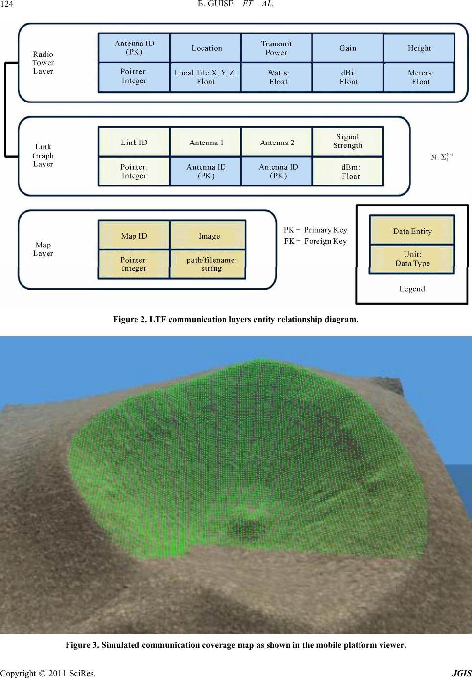
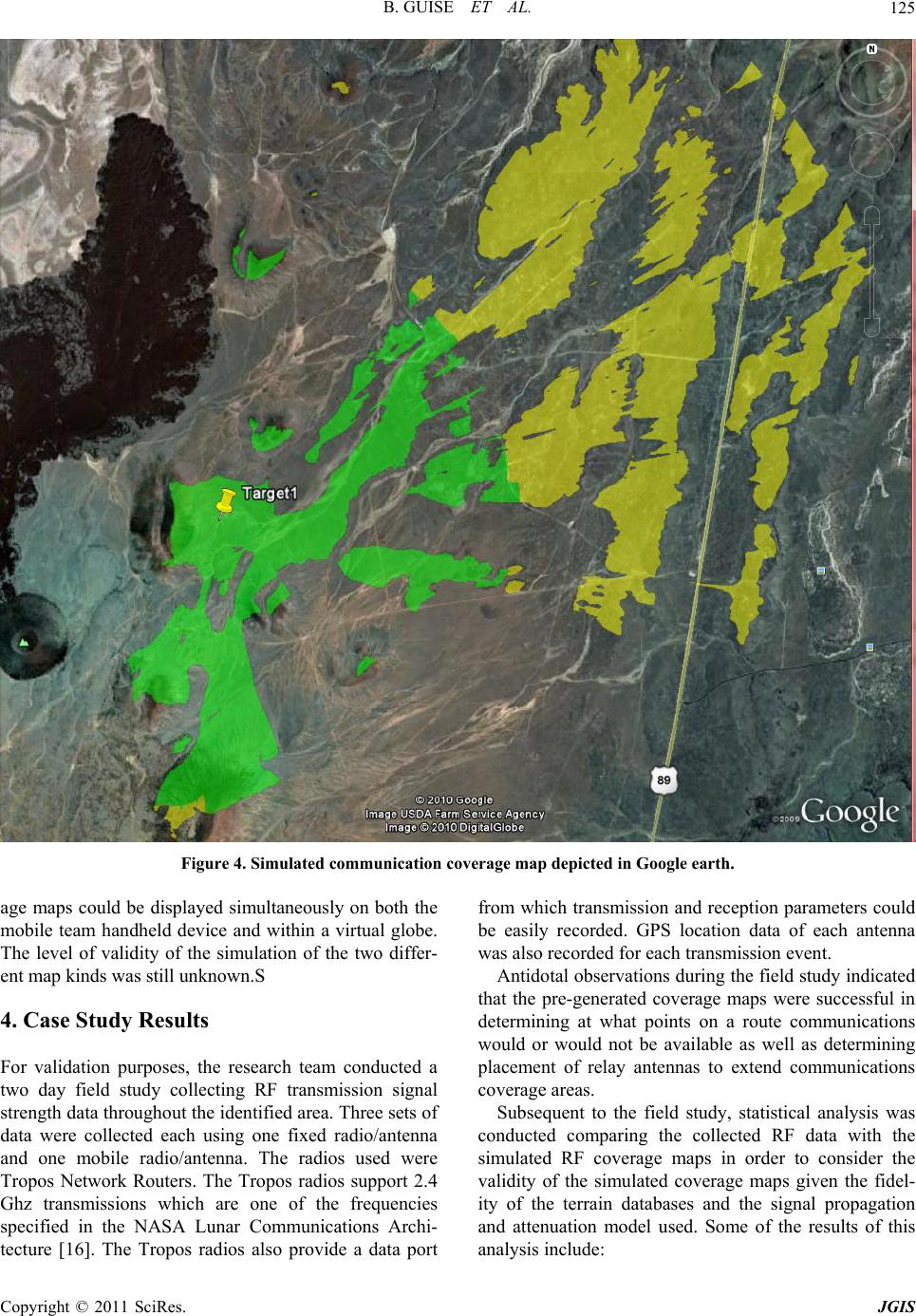
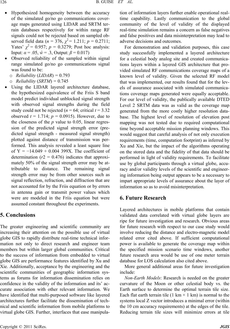
Journal of Geographic Information System, 2011, 3, 120-127
doi:10.4236/jgis.2011.32008 Published Online April 2011 (http://www.SciRP.org/journal/jgis)
Copyright © 2011 SciRes. JGIS
Expectations for Presentation of Engineering and Scientific
Mobile Platform Information within a Virtual Globe
Geographic Information Systems
Brian Guise, Michael D. Proctor
University of Central Florida, Florida, USA
E-mail: brian.guise@l-3com.com, mproctor@ucf.edu
Received January 9, 2011; revised January 17, 2011; accepted January 20, 2011
Abstract
Layered information systems like Google Earth have revolutionized public access to and visualization of
geographic information through virtual globes. Separately, geo-specific technical information has been ad-
vanced in mobile platforms, both handheld and embedded devices, for the engineering and scientific com-
munities. However, engineering and scientific information has had limited penetration into virtual globe
Geographic Information Systems (GIS). This article explores unmet expectations which may be at the root of
the issue. These expectations include design of the architecture within the originating mobile platform as
well as expression of the level of accuracy and precision necessary for validity of the simulation displayed
through the virtual globe GIS. The article below discusses architecture and validity research that advances
real-time generation of simulated electro-magnetic coverage maps as composed layers within a mobile plat-
form. Further, the research also enables real-time visualization of the simulated coverage maps by a global
team through a virtual globe. Finally, for communication assurance purposes, the level of validity of the
generated simulated coverage maps are analyzed from the perspective of an analog celestial body exploration
mission by a mobile rover and its supporting organization analysis needs.
Keywords: Communication Simulation, Layered Architecture, Validity
1. Introduction
Geo-specific terrain information such as satellite imagery,
aerial photography, and digital map data within the con-
text of Geographic Information Systems (GIS) is com-
monly represented as layers within a virtual globe such
as Google Earth, Microsoft Virtual Earth, and NASA
World Wind. The validity of the virtual globe represen-
tations are subject to the scrutiny of the public. Satisfac-
tion of user needs for specific geospatial points of inter-
est such as location of gas stations, hotels, and restau-
rants have popularized the use of virtual globes and led
to increased numbers of layers and density of content in
those layers. For the greater scientific and engineering
communities, the virtual globe GIS and customized GIS
systems have furthered collaboration and technical in-
formation distribution between engineering and scientific
teams [1-7]. However, while Google Earth has proven to
be popular for displaying geo-specific data, the API often
does not provide the users required level of data interac-
tion or data retrieval necessary to support real time
simulation. Further, validity issues impede expansion of
the use of virtual globe for engineering and scientific
tasks.
Beyond the popular virtual globe applications, there
are numerous examples of customized GIS systems
which are used for engineering and scientific tasks by
overlaying technical and scientific user specific data on
geo-specific topographic databases. Hydroseek enables
geo-spatial search and linkage of hydrological data from
three repositories, the National Water Information Sys-
tem, Chesapeake Bay Information Management System,
and National Atmospheric Deposition Program to a sat-
ellite image based user query interface [4]. Microsoft is
developing a system called Sensor Map which is de-
signed to interact with real-time sensors and web based
information sources to provide geo-spatial mapping of
user specified data [5]. Singh and Dowerah [6] use geo-
graphic information system for mapping a variety of dif-
ferent geology map types of mineralized zones and em-
B. GUISE ET AL. 121
bedded remote sensing data to support mineralogy ex-
ploration. Xu and Xie [7] identify the rapid growth in
embedded Geographic Information Systems for mobile,
often autonomous, platform needs by exploration engi-
neers and scientists, and propose a general system de-
sign.
The ultimate goal of this research is advancement of
valid real-time display of high fidelity scientific and en-
gineering simulations from mobile platform as layers in
virtual globes. The specific topic of this research in-
volves real-time display of dynamically varying simula-
tions of electro-magnetic fields occurring on celestial
bodies simultaneously in both mobile platforms and vir-
tual globe systems.
2. Case Study Architecture Requirements
Our specific case study focuses on the software architec-
ture needed for dynamic and simultaneous display on
mobile platforms and in a virtual globe GIS of valid
real-time simulations of communication coverage maps
for missions on a lunar analog site. Valid simulated cov-
erage maps portend to advance the safety of manned and
robotic exploration teams through increased assurance of
communications between explorations teams remotely
separated from secure base stations and supporting in-
stallations. Space exploration risks are multi-faceted both
in terms of human lives and equipment [8]. Approaches
to reducing these risks include mission planning, mission
rehearsal, mission mirroring, after-action review, and
life-cycle engineering of systems suited to meet mission
requirements identified through validated, high-fidelity
simulations and physical testing [9,10]. Display of mis-
sion data through virtual globes extends analysis and
feedback for the phases beyond the confines of the mis-
sion team to interested parties throughout the world.
To advance these concepts we designed architecture,
built a software prototype, conducted a field study and
analyzed the results. Analysis assessed the performance
and validity of simulated communication coverage maps
generated by that prototype for missions on an analog
lunar study site. Critical to dynamic generation is validity
of the simulation communications coverage map given
radio parameters, dynamic mobile relay antenna place-
ments, surface topology, and regolith characteristics af-
fecting radio frequency (RF) propagation and attenuation.
Generation of valid simulations of dynamic communica-
tion coverage maps increases assurance that the routes
taken and placements of relay antennas by mobile
manned or robotic entities will maintain continuous con-
tact with other mobile entities, fixed site base stations,
and/or Earth linked communications satellites.
Desired functionality of the enabling architecture in-
cludes:
Real-time generation of valid simulated communi-
cations coverage maps for mission planning, mis-
sion rehearsal, mission mirroring, after-action re-
view, and life cycle engineering through simula-
tion-based acquisition;
The capability to model real-time deployment of
relay antennas to extend fixed antenna ranges and
simulate valid communicate coverage maps for
real-time mission re-planning opportunities and
urgencies;
Output of map data in a Google Earth viewable
format to facilitate extended (global and/or celes-
tial) mission team interaction and global feedback
Given the risks associated with lost communication
between a remote exploration team and supporting teams,
factors that degrade communications assurance must be
understood in order to create a computer model validated
for simulation of the phenomenon for the region of in-
terest. While the scope of the factors impacting commu-
nication assurance far exceed the scope of this research,
line of sight between receiver and sender represents one
fundamental factor given the modeled UHF frequencies
of interest in our case study. Fidelity of elevation posts
within a computer model of a geo-specific region of the
earth or celestial body directly impact correlation be-
tween the synthetic representation of the region within
the simulation and actual region on the earth or on the
celestial body. The level of elevation post fidelity and RF
model needed to provide a level of assure of a valid
simulation of communication coverage is partially ad-
dressed in this research.
Xu and Xie [7] identify basic performance criteria for
mobile terminals when they state: “It’s necessary to ana-
lyze smart mobile terminals such as, PDA or PMP and
design a hierarchical sub-blocks vector data model. The
key of spatial data organization is data index and query.
The performance of spatial index will directly affect the
whole system performance.” These performance re-
quirements were similar to our identified basic require-
ments. In addition to the assumed need for a high per-
formance spatial index and query for UHF frequency
pairings is correlation of UHF as well as other expected
future electro-magnetic pairings with virtual globe GIS
layers. Hence a layered software architecture was envi-
sioned to provide rapid and high-fidelity, geo-specific
layers of information that could correspond to virtual
globe GIS layers. Layers within a user-manipulated en-
gineering or scientific database also enables the use of
algorithms (such as line of sight calculations) to be per-
formed on the specific data types within that layer in
order to create corresponding additional layers of infor-
mation.
Copyright © 2011 SciRes. JGIS
B. GUISE ET AL.
122
To shorten development time, existing layered soft-
ware architectures were considered for modification and
reuse. Primary considerations were given to high resolu-
tion representation of terrain, rapid calculation of line of
sight, and operation on mobile autonomous platforms.
One layered architecture meeting these criteria and iden-
tified for possible use currently supports training. This
was also consistent with the mission related goals of our
case study. The fundamental capabilities of the layered
architecture identified derived from its training mission
include:
A terrain grid resolution of 1 meter.
10 cm elevation accuracy.
Optimized Line-of-Site (LOS) calculation.
Capability to run on a man-portable computing de-
vice (Palm PC).
In mission rehearsal, for example, terrain knowledge
from a very accurate layered architecture database is
used in the line-of-sight calculations to prevent modeled
projections from passing through hills or other repre-
sented features. Further the layered architecture identi-
fied had a proven record of rapid, near real-time line of
sight (LOS) calculation on terrain with one meter post
separation [11-13]. However, past implementations of
this layered architecture typically only encompassed a 2
km × 2 km physical area. This physical area was far less
than our expected physical area thus creating a research
question, what level of computational performance will
be demonstrated on a far greater physical area?
The layered architecture also leveraged commercial
graphics and computer science domains to implement
data storage structures and algorithms which provide
optimized LOS calculation. Terrain data is stored in
pages that represent 1 square kilometer of terrain. Terrain
elevations are provided as a 16 bit integer value at grid
post spacing of 1 meter. Culling grids are defined for 10
by 10 post areas and for larger 100 by 100 post areas.
The terrain skin is stored in a hierarchical three level tree
structure - the lowest level being the 1 meter grid and the
highest being the 100 × 100 meter post grid.
To calculate line of sight the layered architecture uses
a two-dimensional digital difference analyzer, which is
highly optimized to rapidly traverse a regularly spaced
grid. The LOS routine checks the ray against height of
terrain within culling grids which it crosses, starting with
the largest grid and calculating child nodes (smaller grids)
only if the ray is lower than the terrain height of the par-
ent grid.
Features in the layered architecture are represented as
leaf nodes in a bounding volume hierarchy (BVH) tree.
Each node in a BVH tree is a spatial volume that fully
contains all of it child nodes. Geometry of individual
nodes can be basic or complex geometry types: ellipsoids,
columns, triangle meshes, etc. Higher level culling vol-
umes use simple solid geometry types to allow faster
intersection checks. The feature intersection algorithm
detects root node intersections and if the intersected node
is defined as a culling node then its child nodes will be
checked for intersection. The BVH tree is optimized for
attenuated LOS calculations and will always check clos-
est nodes first. Material attributes can be assigned to
features in order to calculate attenuation of the LOS ray.
For this particular architecture, the terrain database
representation and runtime reasoning services operate
entirely in Cartesian coordinates, with no assumptions
whatsoever about the planetary reference ellipsoid. All
calculations are performed in local Cartesian coordinate
systems tangent to the reference ellipsoid; a global Car-
tesian system is used to coordinate between different local
systems. Due to the Cartesian representation, layering
architecture has no difficulty handling high-latitude or
polar regions.
3. Case Study Methodology
To address the requirements of this GIS case study, im-
provements to above layered architecture needed to be
performed. First, a simulated communications coverage
layer needed to be created within the layered architecture
that included the capability to input radio antenna loca-
tions, and radio transmission properties, antenna gain,
and antenna height. This data was sufficient to support a
simple communications propagation and attenuation al-
gorithm, the Friis transmission equation, which calcu-
lates signal strength at the receiving antenna [14]. LOS
needed for RF communications was implemented as a
layer in the architecture using Global Position System
(GPS) locations and sensor direction to calculate the
signal trajectory. The resulting layer of signal trajectories
were viewed as communication coverage maps through
the existing interface that was modified to accommo-
dated visualization of the added communications layer
components. Controls added to the interface included
antenna placement, antenna parameter and transmission
power specification, and selection of RF model.
In addition to the performance features of a successful
GIS identified above, must be added analysis of the un-
derlying validity of the outcomes of the information
search results. UHF signals can be blocked by interven-
ing terrain. To examine the impact of elevation post fi-
delity on simulated UHF communication coverage map
validity, two layered architecture databases for the ana-
log lunar region were created using different resolution
source data [15]. The lower resolution elevation post
database considered was the Shuttle Radar Topography
(SRTM) Digital Terrain Elevation Data (DTED) Level 2
Copyright © 2011 SciRes. JGIS
B. GUISE ET AL.
Copyright © 2011 SciRes. JGIS
123
ered architecture used in the case study. data with approximately 30 meter elevation post separa-
tion. The higher-resolution elevation post database con-
sidered was the Light Detection and Ranging (LIDAR)
database with one meter post separation. Both databases
were obtained for a 27 km × 27 km lunar analog site that
included areas of interest for our case study. While
SRTM database post separation met DTED Level 2
standards, the accuracy of elevation posts within far ex-
ceeded the minimum DTED accuracy standards. For the
purposes of creating the communication coverage map
within our layered architecture, the SRTM database was
interpolated to within 10 meters. Due to computation
load issues within the notion of at maximum an over-
night mission planning scenario, the LIDAR database
post separation was increased by sampling every 10 me-
ters posts from the original database. The fidelity of the
terrain representation is of interest as greater density,
higher accuracy elevation posts are expected to yield a
more valid simulated communication coverage map but
are more costly to create and computationally demanding
to use. A communication coverage map using the SRTM
database for this region took approximately 2 hours to
create. A communication coverage map using the 10
meter sampled LIDAR database for this region took ap-
proximately 12 hours to create (suitable for an overnight
mission planning scenario).
Figure 2 below graphically depicts the entity rela-
tionships within the layered terrain:
The combination of signal propagation and attenuation
with elevation postings created the basic components to
produce and demonstrate a simulated mission-time com-
munications coverage map in the synthetic representation
of the region of interest. To enhance readability by the
user, the simulated communications coverage maps used
selectable coloration to indicate signal strength at each
location. Color indication of signal strength aids ease of
use and rapid comprehension of the coverage map. Three
color levels (shown in Figures 3 and 4) represent signal
strength used; green represents 802.11G capable data
rates, yellow indicates 802.11 A/B capable data rates and
no color indicates lower than 802.11 A/B or no commu-
nications signal. Figure 3 provides a screenshot showing
a coverage map rendered in the layered architecture
viewer.
The capability to export coverage maps to Google
Earth compatible kml format was also created. Figure 4
provides a screenshot of an exported kml format com-
munication coverage map as viewed in Google Earth.
The above engineering research created and demon-
strated a user-friendly, layered architecture for a mobile
platform for two different kinds of simulated communi-
cation coverage maps (LIDAR and STRM). The cover- Figure 1 below graphically depicts the resulting lay-
Figure 1. Layered architecture with communication layer added.
B. GUISE ET AL.
124
Figure 2. LTF communication layers entity relationship diagram.
Figure 3. Simulated communication coverage map as shown in the mobile platform viewer.
Copyright © 2011 SciRes. JGIS
B. GUISE ET AL.
Copyright © 2011 SciRes. JGIS
125
Figure 4. Simulated communication coverage map depicted in Google earth.
age maps could be displayed simultaneously on both the
mobile team handheld device and within a virtual globe.
The level of validity of the simulation of the two differ-
ent map kinds was still unknown.S
4. Case Study Results
For validation purposes, the research team conducted a
two day field study collecting RF transmission signal
strength data throughout the identified area. Three sets of
data were collected each using one fixed radio/antenna
and one mobile radio/antenna. The radios used were
Tropos Network Routers. The Tropos radios support 2.4
Ghz transmissions which are one of the frequencies
specified in the NASA Lunar Communications Archi-
tecture [16]. The Tropos radios also provide a data port
from which transmission and reception parameters could
be easily recorded. GPS location data of each antenna
was also recorded for each transmission event.
Antidotal observations during the field study indicated
that the pre-generated coverage maps were successful in
determining at what points on a route communications
would or would not be available as well as determining
placement of relay antennas to extend communications
coverage areas.
Subsequent to the field study, statistical analysis was
conducted comparing the collected RF data with the
simulated RF coverage maps in order to consider the
validity of the simulated coverage maps given the fidel-
ity of the terrain databases and the signal propagation
and attenuation model used. Some of the results of this
analysis include:
B. GUISE ET AL.
126
Hypothesized homogeneity between the accuracy
of the simulated go/no go communications cover-
age maps generated using LIDAR and SRTM ter-
rain databases respectively for within range RF
signals could not be rejected based on sampled ob-
served field data (n = 376, χ2 = 1.211; p = 0.2711;
Yates’ χ2 = 0.957; p = 0.3279; Post hoc analysis:
Input: α = .05, ŵ = .3, Output: ß = 0.017)
Observed reliability of the sampled within signal
range simulated go/no go communications signal
was found to be:
o Reliability (LIDAR) = 0.793
o Reliability (SRTM) = 0.745
Using the LIDAR layered architecture database,
the hypothesized equivalence of the Friis S band
model predict individual unblocked signal strength
with observed signal strengths during the field
study could not be rejected (n = 64; critical t = 3.32
observed t = 1.714; p = 0.0915). However, due to
the closeness of the p value to 0.05, linear regres-
sion of the predicted signal strength error (pre-
dicted signal strength - measured signal strength)
plotted against distance of transmission was per-
formed. This analysis revealed a least square line
of Y = 14.049 + 0.004 399X. The coefficient of
determination (r2 = 0.476) indicates that approxi-
mately 50% of the signal strength error may be at-
tributable to distance. The remaining signal
strength error may be from other sources such as
signal reflection, refraction, and diffraction that are
not accounted for by the Friis equation or by errors
in antenna gain or transmit power values which
were are modeled in the Friis equation but were
assumed constant throughout the experiments.
5. Conclusions
The greater engineering and scientific community are
increasing their attention on the possible use of virtual
globe GIS to rapidly distribute real-time technical infor-
mation not only to direct research and engineer team
members but within larger global communities. Critical
to the success of information from embedded to virtual
globe GIS are performance features identified by Xu and
Xie. Additionally, acceptance by the engineering and the
scientific communities of geographic information sys-
tems as forums for information dissemination relies on
confidence in the validity of the information and its’ ac-
curate association with other relevant information. We
have identified that multi-purposed software like layered
architectures further facilitate the dissemination of tech-
nical and scientific information from mobile platforms to
virtual globe GIS. Further, interfaces that ease manipula-
tion of information layers further enable operational real-
time capability. Lastly communication to the global
community of the level of validity of the displayed
real-time simulation remains a concern as false negatives
and false positives and data misinterpretation may lead to
adverse decisions and outcomes.
For demonstration and validation purposes, this case
study successfully implemented a layered architecture
for a celestial body analog site and created communica-
tions layers within a layered GIS architecture that pro-
vided simulated RF communications coverage maps of a
known level of validity. Given the selected RF model
that was implemented, our results found that for the lev-
els of assurance associated with simulated communica-
tions coverage maps generated were equally acceptable.
For our level of validity, the publically available DTED
Level 2 SRTM data was as valid as the coverage map
generated from the more costly higher resolution data-
base. The highest level of resolution of elevation post
mapping was not tested due to required computational
time beyond acceptable mission planning windows. This
would suggest that careful analysis of not only execution
requirements (time, computation footprint) as inferred by
Xu and Xie, but the impact of the algorithms operating
on the stored data and the fidelity of that data should be
performed in light of validity requirements. To facilitate
use by global participants through a virtual globe, accu-
racy and/or validity levels of the scientific and engineer-
ing information being output appears to be a necessary to
impart appropriate levels of assurance about the layer of
information so as to avoid misinterpretation.
6. Future Research
Layered architectures in mobile platforms that contain
validated data correlated with virtual globe layers are
ripe for future investigation and research. Obvious areas
for future research with respect to our case study would
involve reducing the distance and electro-magnetic model
related error cited above. If sufficient computational
power is available to generate the coverage map within
the specified mission scenario time windows, another
future research area would be use of one meter terrain
database for LOS calculation also cited above.
More general additional areas for future investigation
include:
Non-Earth Models: Research is needed on the greater
curvature of the Moon or other celestial body vs. the
Earth surface to determine the optimal terrain tile size.
Each flat earth terrain tile (1 km × 1 km) is normal to the
systems local Z vector introduces a minimal error (within
the 10 cm accuracy requirements) at the edges of the tile.
Reducing terrain tile sizes will minimize errors at tile
Copyright © 2011 SciRes. JGIS
B. GUISE ET AL.
Copyright © 2011 SciRes. JGIS
127
edges but increase processing time. Elongated ellipsoids
combined with this Cartesian coordinate approach may
also permit the modeling of non-spherical bodies such as
near earth objects.
Subsurface and above surface Models: Research is
needed on determining what subsurface or above surface
geo-specific data to represent, the nature of the represen-
tation, and the level of fidelity is needed. For instance
mineralogy could be defined in a subsurface layer by
defining 3 dimensional geometric polygonal shapes con-
taining mineral properties. Similar polygonal shapes de-
fined above the terrain surface could be used to represent
location specific data of interest to the user such as mag-
netic or radiation fields.
Navigation Simulation: Research is needed on the
contribution of wirelessly streamed terrain database up-
dates augment or improve pre-mission generated terrain
databases with locally collected terrain data.
Heliophysics layers and Route Planning: Research is
needed on the degree and nature of layered representa-
tions of heliophysical exposure elements are appropriate.
Heliophysical exposure increases danger to crews but
conversely may support energy recharging requirements.
Heliophysical effects layers may enable route planning in
areas shadowed by mountains or craters, or maximizes
solar exposure in order to keep power array output at its
peak may be appropriate.
7. References
[1] A. J. Chen, G. Leptoukhm, S. Kempler and L. P. Di,
“Visualization of NASA Earth Science Data in Google
Earth,” Geoinformatics, Proceedings of the SPIE, Vol.
7143, 2008, pp. 29-42.
[2] R. Kamadjeu, “Tracking the Polio Virus down the Congo
River: A Case Study on the Use of Google Earth in Pub-
lic Health Planning and Mapping,” International Journal
of Health Graphics, Vol. 8, No. 4, 2009, pp. 1-12.
[3] M. N. K. Boulos, M. Scotch, K.-H. Cheung and D. Bur-
den, “Web GIS in Practice VI: A Demo Playlist of
Geo-Mashups for Public Health Neogrographers,” Inter-
national Journal of Health Geo- graphics, Vol. 7, No. 38,
2008, pp. 1-16.
[4] B. Beran and M. Piasecki, “Engineering New Paths to
Water Data,” Computers & Geosciences, Vol. 35, No. 4,
2009, pp. 753-760. doi:10.1016/j.cageo.2008.02.017
[5] S. Nath, J. Liu and F. Zhao, “SensorMap for Wide-Area
Sensor Webs,” IEEE Computer, Vol. 40, No. 7, 2007, pp.
90-93.
[6] B. Singh and J. Dowerah, “Geospatial Mapping of
Singhbhum Shear Zone (SSZ) with Respect to Mineral
Prospecting,” Journal of Geographic Information system,
Vol. 2, 2010, pp. 177-184.
doi:10.4236 /jgis.2010.23025
[7] Z. Y. Xu and Z. Xie, “Research on Key Technology of
General Embedded GIS,” Journal of Geographic Infor-
mation System, Vol. 2, 2010, pp. 15-18.
doi:10.4336/jgis.2010.21004
[8] NASA/SP-2004-6113, “Bioastronautics Roadmap, a Risk
Reduction Strategy for Human Space Exploration,”
NASA Scientific and Information Program Office, Feb-
ruary 2005.
[9] J. F. Connolly, “Constellation Program Overview,” NASA
Presentation, 2006.
http://www.nasa.gov/pdf/163092main_constelltion_progr
am_overview.pdf
[10] D. Monell, “NASA Constellation Program Modeling and
Simulation,” NASA Presentation, May 2007.
[11] S. Borkman, G. Peele and C. Cambell, “An Optimized
Synthetic Environment Representation Developed for
OneTESS Live Training,” Interservice/Industry Training,
Simulation, and Education Conference, 2007.
[12] J. Campos, S. Borkman, G. Peele and C. Cambell, “To-
ward Cross Domain Terrain Services,” Interser-
vice/Industry Training, Simulation, and Education Con-
ference, 2008.
[13] W. Baer, T. R. Campbell, J. Campos and W. Powell,
“Modeling Terrain for Geo-pairing and Casualty As-
sessment in OneTESS,” Modelling and Simulation for
Military Operations III, Proceedings of SPIE, Vol. 6965,
11 April 2008.
[14] J. Lavergnat and M. Sylvain, “Radio Wave Propa- gation
Principles and Techniques, ” John Wiley & Sons, Ltd.,
West Sussex, 2000.
[15] NASA Website, “NASA’s Desert Research and Techno-
logy Studies (D-RATS),” 2010.
http://science.ksc.nasa.gov/
d-rats
[16] J. Schier, “NASA’s Lunar Space Communication and
Navigation Architecture,” American Institute of Aero-
nautics and Astronautics, September 24, 2007.
[17] B. McLarnon, “VHF/UHF/Microwave Radio Pro-paga-
tion: A Primer for Digital Experimenters,” TAPR/ARRL
Digital Communications Conference, 1997.
http://www.tapr.org/ve3jf.dcc97.html