 Journal of Geoscience and Environment Protection, 2014, 2, 36-41 Published Online April 2014 in SciRes. http://www.scirp.org/journal/gep http://dx.doi.org/10.4236/gep.2014.22006 How to cite this paper: Li, M. C., & Zhang, J. G. (2014). Retrospective Environment Carrying Capacity Assessment and Comparison for Marine Reclamation. Journal of Geoscience and Environment Protection, 2, 36-41. http://dx.doi.org/10.4236/gep.2014.22006 Retrospective Environment Carrying Capacity Assessment and Comparison for Marine Reclamation Mingchang Li1, Jingguo Zhang2 1Laboratory of Environmental Protection in Water Transport Engineering, Tianjin Research Institute of Water Transport Engineering, Tianjin, China 2Tianjin Oceanic Administration, Tianjin, China Email: lmcsq19 97@163.co m Received Dec emb er 2013 Abstract For improving the managed level and guiding the environmental management of reclamation engineering, a synthetic assessment method based on cloud theory is applied to evaluate the en- vironment carrying capacity of part of Tianjin Port in this paper. This retrospective assessment of carrying capacity aims to obtain the historical development situation of reclamation domain. The research is meaningful and efficient for judging the feasibility of marine reclamation. Keywords Retrospective; Environment Carrying Capacity; Assessment; Reclamation; Cloud Theory 1. Introduction Recently, marine reclamation has resulted in the pollution of water environment and the destruction of ecologi- cal system. The environmental and ecological problem is the important restricting factor for regional sustainable development. How to evaluate the environmental impact of marine reclamation is very important for managing and guiding the district development scientifically. Tianjin Port is an important port in our country. The rapid development of Tianjin Port results in more de- mand of marine resources, especially the land resource. So a new reclamation planning has been studied and presented to solve the problem of development space, namely Ergangdao Island. But the Tianjin Port locates in the west of Bohai Bay, the environmental impact is the key problem for deciding the feasibility of Ergangdao Island reclamation. So the historical environment situation of this district must be studied to obtain the basic condition of reclamation. A basic assessment problem exists in this research. The characteristic of assessment is a combined process between assessment factors and assessment standard. So many assessment methods have been proposed and ap- plied to many fields including ocean water quality and carrying capacity, such as Individual and comprehensive index method, fuzzy comprehensive evaluation method (Qian, 2006), grey clustering method (Feng, Wang, & 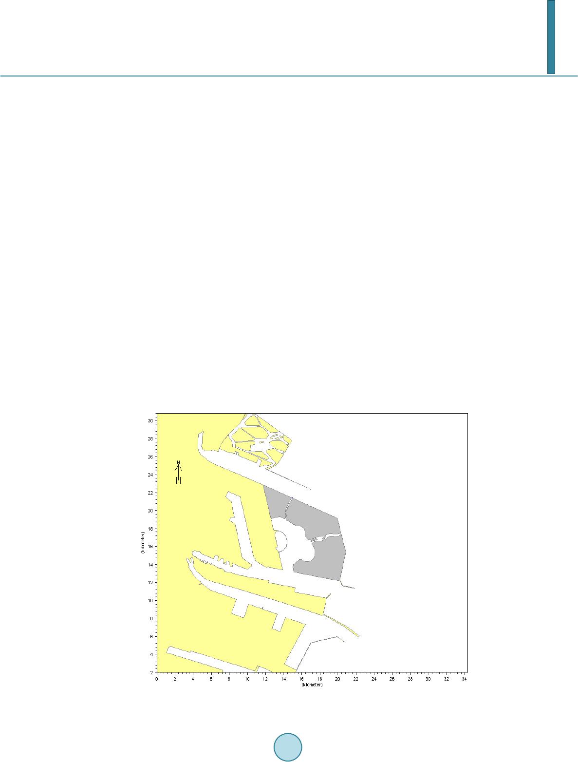 M. C. Li, J. G. Zhang Zhang, 2000), matter element model analysis method (Pan, Fu, & Liang, 2002), projection pursuit method (Wang, 2011), artificial neural network method (Chen & Li, 2005) and nonlinear set pair analysis method (Li, Zhang, & You, 2010), but several defects exist in these methods (Li & Liu, 2009). In this paper, a synthetic assessment method, namely cloud theory (Li & Du, 2005) is applied to evaluate the historical situation in Tianjin district, based on the characteristic of randomness and ambiguity. The research re- sults show the situation of reclamation district and the efficiency of this method. 2. Assessment Method 2.1. Cloud Theory Based on probability and fuzzy mathematic, the basic algorithm of cloud theory is to build an uncertainty trans- formation model for the exchange between concept and quantity. The cloud theory model has been applied to system evaluation, algorithm improvement, decision support, intelligent control, data mining, knowledge dis- covery and network security (Fu, Li, & Wang, 2011). 2.2. Procedure of Cloud Theory Assessment Method The randomness and ambiguity of concept can reacted in cloud theory by the mathematical expectation, entropy and hyper entropy. The detailed assessment procedure has seven steps (Li, Zhang, Si, Liang, & Sun, 2012). 3. Case Study Tianjin Port is an important support for district economy development. A new reclamation planning named that Ergangdao Island is proposed to improve the land resource for the rapid development of Tianjin Port and the demand of marine resources. In this research, the historical environment situation of this district is studied for obtaining the basic condition of reclamation and judging the feasibility of Ergangdao Island reclamation. Marine reclamation of Ergangdao Island is shown in Figure 1. The grey section in Figure 1 is the panning reclamation of Ergangdao Island. Figure 1. The location of Ergangdao Island.  M. C. Li, J. G. Zhang 3.1. Basic Situation of Reclamation Domain The total area of Tianjin marine is about 15,900 km2. It is very shallow and its averaged water depth is less than 20 m. The sea bottom is very flat and its mean slope is less than 2‰. 3.2. Assessment Indexes of Environment Carrying Capacity Thirteen assessment indexes (Suspended Substance (SS), COD, DO, DIN, Phosphate (Ph), Petroleum (Pe), Hg, As, Cu, Zn, Cd, Pb and Cr) in marine waters, ten assessment indexes (Organic Carbon (OC), Sulfide (Su), Pe- troleum (Pe), Hg, As, Cu, Zn, Cd, Pb and Cr) in sediment and five assessment indexes (Chl, Phytoplankton (Pp), Zooplankton (Zp), Benthos (Be) and Intertidal benthos (Ib)) are selected for evaluating the current situation of engineering marine district. In this paper, single factor carrying capacity and multiple factors comprehensive carrying capacity are studied for evaluating the historical situation of reclamation domain from multiple angles. 3.3. Assessment Levels of Environment Carrying Capacity The assessment standard of the whole indexes is used to evaluate retrospective environment carrying capacity listed in Table 1. Table 1. Level standards of assessment index. Assessment indexes Level standards Good (I) General (II) Poor (III) Very poor (IV) SS 0-10 10-100 100-150 150-Max1 COD 0-2 2-3 3-4 4-Max DO Max -6 6-5 5-4 4-3 D IN 0-0.2 0.2-0.3 0.3-0.4 0.4-Max4 Ph 0-0.015 0.015~0.03 0.03~0.045 0.045-Max5 Pe 0-0.05 0.05~0.3 0.3~0.5 0.5-Max Hg 0-0.05 0.05~0.2 0.2~0.5 0.5-Max As 0-20 20-30 30-50 50-Max8 Cu 0-5 5-10 10-50 50-Max9 Zn 0-20 20-50 50-100 100-Max Cd 0-1 1~5 5~10 10-Max Pb 0-1 1~5 5~10 10-Max12 Cr 0-50 50-100 100-200 200-Max13 OC 0-2 2-3 3-4 4-Max SU 0-300 300-500 500-600 600-Max Pe 0-500 500-1000 1000-1500 1500-Max16 Hg 0-0.2 0.2-0.5 0.5-1.0 1.0-Max17 As 0-20 20-65 65-93 93-Max Cu 0-35 35-100 100-200 200-Max Zn 0-150 150-350 350-600 600-Max20 Cd 0-0.5 0.5-1.5 1.5-5 5-Max21 Pb 0-60 60-130 130-250 250-Max Cr 0-80 80-150 150-270 270-Max Chl 0-2 2-5 5-10 10-Max24 Pp 0-25 25-50 50-150 150-Max25 Zp Max -3 3-2 2-1 1-0 Be Max -3 3-2 2-1 1-0 Ib Max28-3 3-2 2-1 1-0 Note: M ax1-Max 28 is the max value of water quality measurement data owing to not be obtained by the water quality standard.  M. C. Li, J. G. Zhang 3.4. Results Analysis Following the assessment steps of cloud theory, the single factor and multiple factors method are applied to evaluate the water quality, sediment, ecology and comprehensive level in Table 2-8. From the assessment results in Table 2-3, the water quality is good in 2010 and 2012. But the Phosphate is poor in the research years. The sediment quality is good in 2010 and 2012 shown in the Table 4 and Table 5. Especially 2010, all the indexes are the level I. The level of ecology indexes is poor (III) in 2010 and 2012. The comprehensive assessment results show the level is acceptable. 4. Conclusion In this paper, a synthetic assessment method based on cloud theory is applied to evaluate the marine reclamation Table 2. Assessment results of water quality in 2010. Assessment indexes Assessment level Single factor Multiple factors SS II I COD II DO I D IN III Ph II Pe I Hg II As I Cu I Zn I Cd I Pb II Cr I Table 3. Assessment results of water quality in 2012. Assessment indexes Assessment level Single factor Multiple factors SS I I COD II DO I D IN III Ph I Pe I Hg II As I Cu I Zn I Cd I Pb II Cr I  M. C. Li, J. G. Zhang Table 4. Assessment results of sediment in 2010. Assessment indexes Assessment level Single factor Multiple fac t ors OC I I SU I Pe I Hg I As I Cu I Zn I Cd I Pb I Cr I Table 5. Assessment results of sediment in 2012. Assessment indexes Assessment level Single factor Multiple factors OC I I SU I Pe I Hg I As II Cu I Zn I Cd I Pb I Cr I Table 6. Assessment results of ecology in 2010. Assessment indexes Assessment level Single factor Multiple factors Chl II III Pp I Zp III Be III Ib I II Table 7. Assessment results of ecology in 2012. Assessment indexes Assessment level Single factor Multiple factors Chl II III Pp III Zp III Be IV Ib I II  M. C. Li, J. G. Zhang Table 8. Comprehensive assessment results. Year Assessment level 2010 I 2012 II carrying capacity of Ergangdao Island in Tianjin Port. Through the retrospective assessment, the historical de- velopment situation in reclamation domain is shown by single factor and multiple factors assessment. The as- sessment results show that the environmental level is acceptable for marine reclamation. Meanwhile, more re- searches need be done for obtaining the environmental impact level of marine reclamation, such as hydrody- namics, water exchange, ecological loss and sediment etc. Acknowledgements This work was supported by the National Natural Science Foundation of China (No. 51209110), the project of Science and Technology for Development of Ocean in Tianjin (KJXH2011-17) and the National Nonprofit In- stitute Research Grants of TIWTE (KJFZJJ2011-01). References Chen, S. Y., & Li, Y. W. (2005). Water Quality Evaluation Based on Fuzzy Artificial Neural Network. Advances in Water Science, 16, 88-91 . Feng, L. H., Wang, J. Y., & Zhang, M. Z. (2000). Grey Clustering Evaluation of Environmental Quality. Environmental Protection Science, 26, 37 -39 . Fu, B., Li, D. G., & Wang, M. K. (2011). Review and Prospect on Research of Cloud Model. Application Research of Com- puters, 28, 420-42 6. Li, D. Y., & Du, Y. (2005). Artificial Intelligence with Uncertainty. Beijing: National Defence Industry Press. Li, J. Z., & Liu, X. Z. (2009). The Application Research of the Theory of Uncertainty Set Pair Analysis in Seawater Eutro- phication Assessment. Mathematics in Practice and Theory, 39, 84-88. Li, M. C., Zhang, G. Y., & You, X. Y. (2010). Set Pair Analysis Method with Nonlinear Membership Function for Sea Wa- ter Quality Assessment. Journal of Hebei University of Technology, 39, 81-86. Li, M. C., Zhang, G. Y., Si, Q., Liang, S. X., & Sun, Z. C. (2012). Synthetic Assessment Method with Cloud Theory for Ma- rine Water Quality. 2012 International Conference on Sustainable Energy and Environmental Engineering, 298, 821-826. Pan, F., Fu, Q., & Liang, C. (2002). Applying Fuzzy Synthesize Judgment in the Study of Water Environment Quality Eval- uation. Envi r onment Engineering, 20, 58-61. Qian, Y. Q. (2006). Macro-Economic Social Evaluation of Water Resources Planning in Dongguang Using Fuzzy Compre- hensive Evaluation Method. Zhujiang Modern Construction, 6, 1-4. Wang, X. (2011). Comprehensive Evaluation of Water Quality Based on Application of Projection Pursuit Model. Ground Water, 33, 5-6..
|