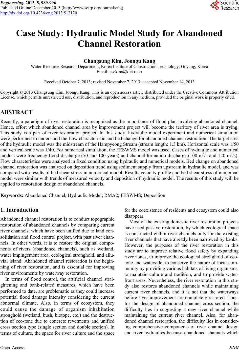
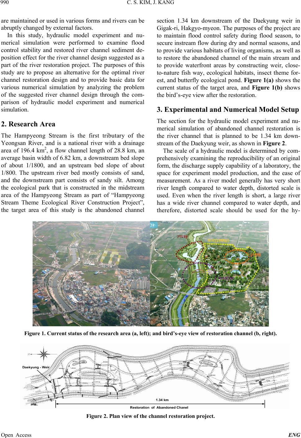
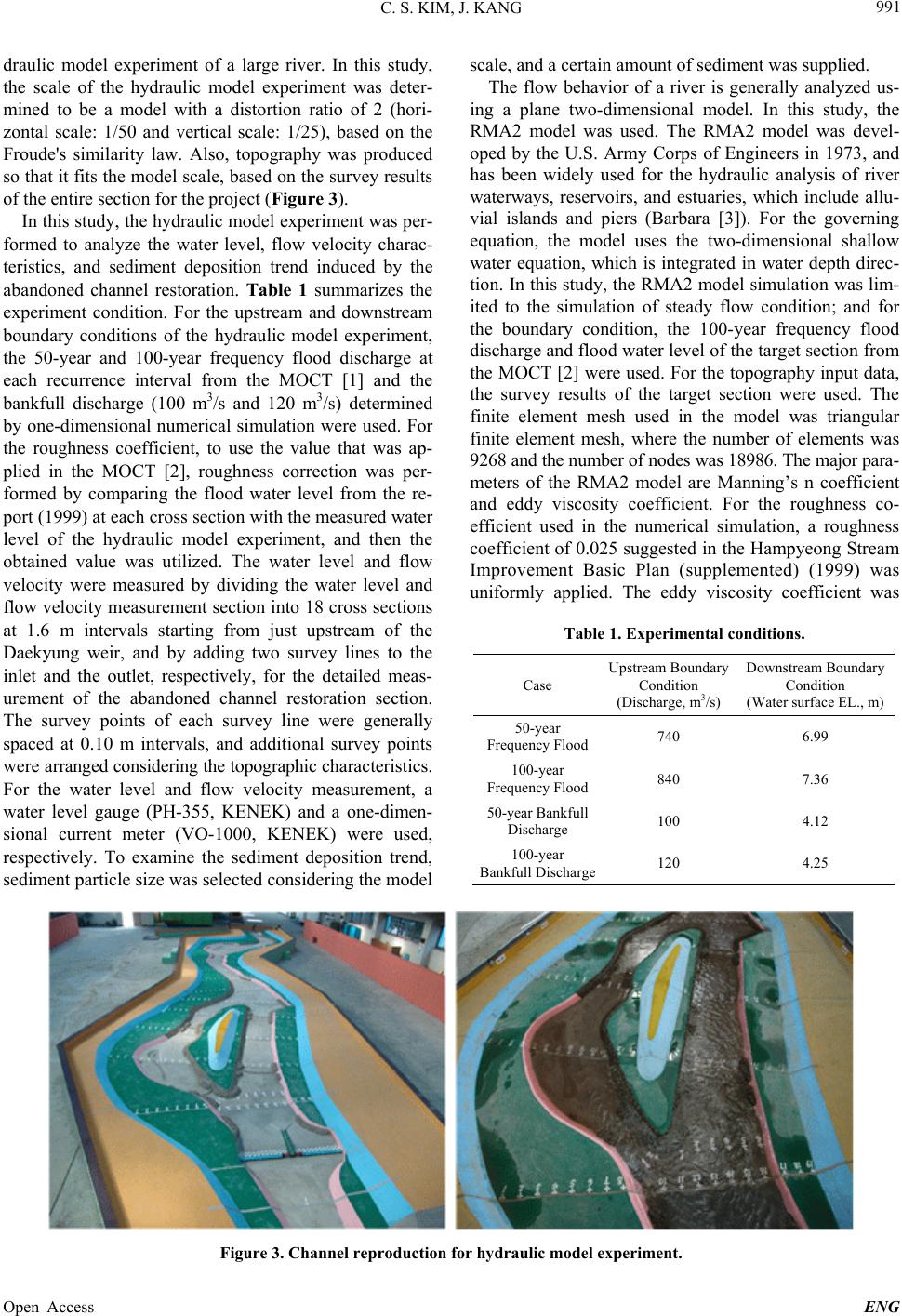
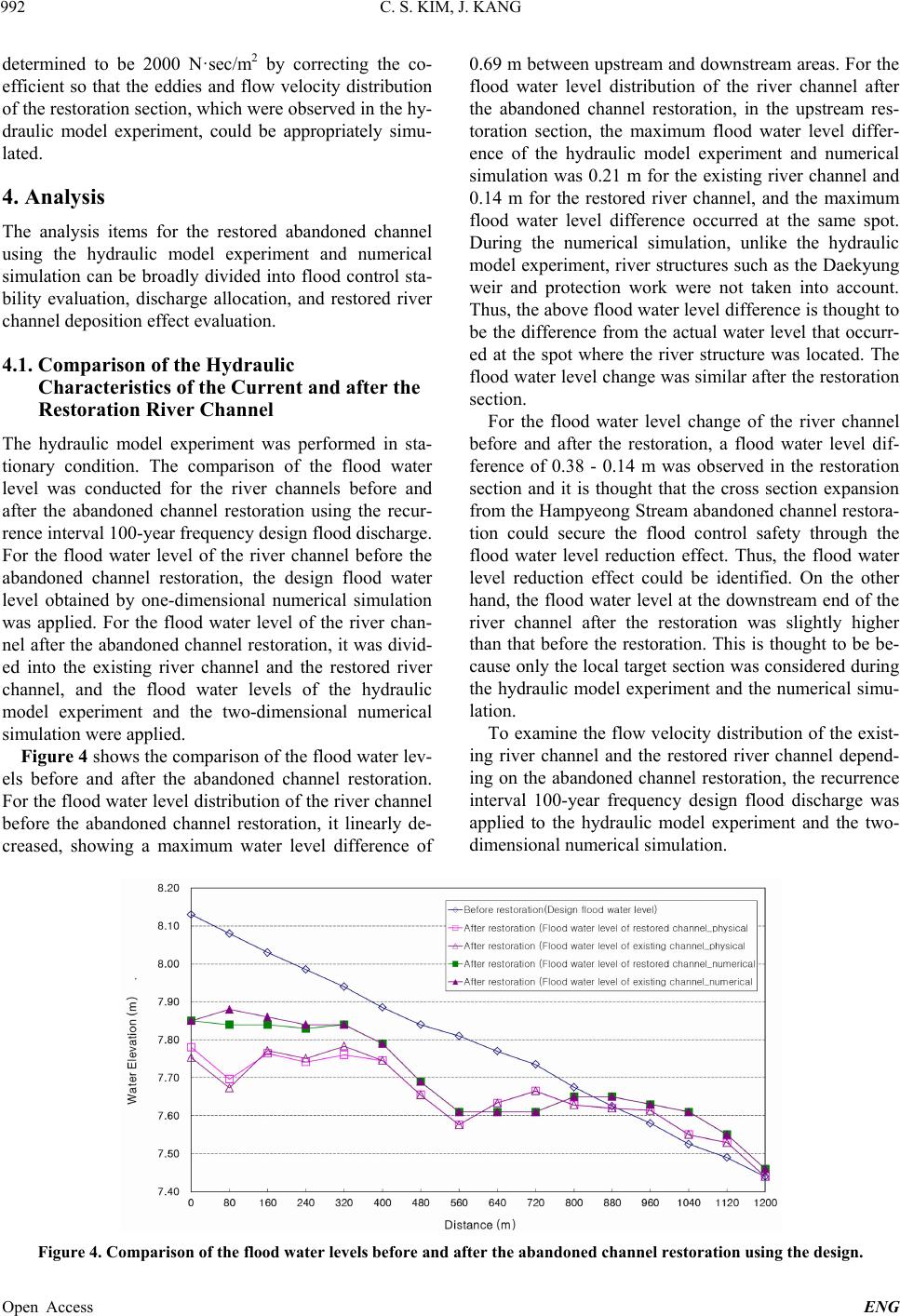
Engineering, 2013, 5, 989-996
Published Online December 2013 (http://www.scirp.org/journal/eng)
http://dx.doi.org/10.4236/eng.2013.512120
Open Access ENG
Case Study: Hydraulic Model Study for Abandoned
Channel Restoration
Changsung Kim, Joongu Kang
Water Resource Research Department, Korea Institute of Construction Technology, Goyang, Korea
Email: csckim@kict.re.kr
Received October 7, 2013; revised November 7, 2013; accepted November 14, 2013
Copyright © 2013 Changsung Kim, Joongu Kang. This is an open access article distributed under the Creative Commons Attribution
License, which permits unrestricted use, distribution, and reproduction in any medium, provided the original work is properly cited.
ABSTRACT
Recently, a paradigm of river restoration is recognized as the importance of flood plan involving abandoned channel.
Hence, effort which abandoned channel area by improvement project will become the territory of river area is trying.
This study is a part of river restoration project. In this study, hydraulic model experiment and numerical simulation
were performed to understand the flow characteristic and bed change for abandoned channel restoration. The target area
of the hydraulic model was the midstream of the Hampyeong Stream (stream length: 1.3 km). Horizontal scale was 1/50
and vertical scale was 1/40. For numerical simulation, the FESWMS model was used. Cases of hydraulic and numerical
models were frequency flood discharge (50 and 100 years) and channel formation discharge (100 m3/s and 120 m3/s).
Flow characteristics were analyzed in fixed cond ition using hydraulic and numerical mode ls. Bed chang e on abandon ed
channel restoration was analyzed on deposition trend using sediment supply from upstream in hydraulic model, and was
compared with results of bed shear stress in numerical model. Results velocity profile and bed shear stress of numerical
model were similar with trends of measured velocity and deposition of hydraulic model. The results of this stud y will be
applied to r estoration design of abandoned channels .
Keywords: Abandoned Channel; Hydraulic Mo del; RMA2; FESWMS; Deposition
1. Introduction
Abandoned channel restoration is to conduct to pographic
restoration of abandoned channels by comparing current
river channels, which have been unified due to land con-
solidation and flood contro l project, with past river chan-
nels. In other words, it is to restore the original compo-
nents of rivers (abandoned channels), such as wetland,
water impingement area, ecological stronghold, and allu-
vial island. Abandoned channel restoration is the begin-
ning of river restoration, and is essential for improving
river environments by waterway restoration.
In terms of flood control, the artificial channel strai-
ghtening and bank-related measures, which have been
performed to date, are problematic as they could increase
potential flood damage intensity considering the current
abnormal climate. Also, in terms of ecosystem, they
could cause the damage of organism inhabitation
stronghold (wetland, bush, biotope, etc.) and the destruc-
tion of eco-tone due to concrete revetments and unified
cross section type (single section and double section). In
terms of culture, the space for river culture and the space
for the coexistence of residents and ecosystem could also
disappear.
Most of the existing domestic river restoration projects
have used passive restoration, by which ecological space
is constructed within river channels only for the existing
river channels that have already been narrowed by banks.
However, the purposes of the river restoration in this
study are to improve relative flood safety by expanding
river zones, to improve the ecological stronghold of eco-
tone and waterside, to conserve the nature of local com-
munity by providing various habitats of living organisms,
to maintain culture and tradition, and to provide water-
front areas. Nevertheless, the river restoration in this stu-
dy also restores abandoned channels while maintaining
current river channels, and it is not that the waterways
before river improvement are completely restored. Thus,
for the design of abandoned channel cross section, the
difficulty lies in suggesting a new river channel while
maintaining the current river channel. Also, for aban-
doned channel restoration, the difficulty lies in consider-
ing comprehensive components of river channel design
and river hydraulics because abandoned channels which
C. S. KIM, J. KANG
990
are maintained or used in various forms and rivers can be
abruptly changed by external factors.
In this study, hydraulic model experiment and nu-
merical simulation were performed to examine flood
control stability and restored river channel sediment de-
position effect for the river channel design su ggested as a
part of the river restoration project. The purposes of this
study are to propose an alternative for the optimal river
channel restoration design and to provide basic data for
various numerical simulation by analyzing the problem
of the suggested river channel design through the com-
parison of hydraulic model experiment and numerical
simulation.
2. Research Area
The Hampyeong Stream is the first tributary of the
Yeongsan River, and is a national river with a drainage
area of 196.4 km2, a flow channel length of 28.8 km, an
average basin width of 6.82 km, a downstream bed slope
of about 1/1800, and an upstream bed slope of about
1/800. The upstream river bed mostly consists of sand,
and the downstream part consists of sandy silt. Among
the ecological park that is constructed in the midstream
area of the Hampyeong Stream as part of “Hampyeong
Stream Theme Ecological River Construction Project”,
the target area of this study is the abandoned channel
section 1.34 km downstream of the Daekyung weir in
Gigak-ri, Hak gyo-myeon . Th e purpos es of the proj ect are
to maintain flood control safety during flood season, to
secure instream flow du ring dry and normal seasons, and
to provide various habitats of living organisms, as well as
to restore the abandoned channel of the main stream and
to provide waterfront areas by constructing weir, close-
to-nature fish way, ecological habitats, insect theme for-
est, and butterfly ecological pond . Figure 1(a) shows the
current status of the target area, and Figure 1(b) shows
the bird’s-eye view after the restoration.
3. Experimental and Numerical Model Setup
The section for the hydraulic model experiment and nu-
merical simulation of abandoned channel restoration is
the river channel that is planned to be 1.34 km down-
stream of the Daekyung weir, as shown in Figure 2.
The scale of a hydraulic model is determined by com-
prehensiv ely examining the reprod ucibility of an original
form, the discharge supply capability of a laboratory, the
space for experiment model production, and the ease of
measurement. As a river model generally has very short
river length compared to water depth, distorted scale is
used. Even when the river length is short, a large river
has a wide river channel compared to water depth, and
therefore, distorted scale should be used for the hy-
Figure 1. Current status of the research area (a, left); and bird’s-eye view of restoration channel (b, right).
Figure 2. Plan view of the channel restoration project.
Open Access ENG
C. S. KIM, J. KANG 991
draulic model experiment of a large river. In this study,
the scale of the hydraulic model experiment was deter-
mined to be a model with a distortion ratio of 2 (hori-
zontal scale: 1/50 and vertical scale: 1/25), based on the
Froude's similarity law. Also, topography was produced
so that it fits the model scale, based on the survey results
of the entire section for the project (Figure 3).
In this study, the hydraulic model experiment was per-
formed to analyze the water level, flow velocity charac-
teristics, and sediment deposition trend induced by the
abandoned channel restoration. Table 1 summarizes the
experiment condition. For the upstream and downstream
boundary conditions of the hydraulic model experiment,
the 50-year and 100-year frequency flood discharge at
each recurrence interval from the MOCT [1] and the
bankfull discharge (100 m3/s and 120 m3/s) determined
by one-dimensional numerical simulation were used. For
the roughness coefficient, to use the value that was ap-
plied in the MOCT [2], roughness correction was per-
formed by comparing the flood water level from the re-
port (1999) at each cross section with the measured water
level of the hydraulic model experiment, and then the
obtained value was utilized. The water level and flow
velocity were measured by dividing the water level and
flow velocity measurement section into 18 cross sections
at 1.6 m intervals starting from just upstream of the
Daekyung weir, and by adding two survey lines to the
inlet and the outlet, respectively, for the detailed meas-
urement of the abandoned channel restoration section.
The survey points of each survey line were generally
spaced at 0.10 m intervals, and additional survey points
wer e arranged considering the topographic char ac te ri st ics .
For the water level and flow velocity measurement, a
water level gauge (PH-355, KENEK) and a one-dimen-
sional current meter (VO-1000, KENEK) were used,
respectively. To examine the sediment deposition trend,
sediment particle size was selected considering the model
scale, and a certain amount of sediment was supplied.
The flow behavior of a river is generally analyzed us-
ing a plane two-dimensional model. In this study, the
RMA2 model was used. The RMA2 model was devel-
oped by the U.S. Army Corps of Engineers in 1973, and
has been widely used for the hydraulic analysis of river
waterways, reservoirs, and estuaries, which include allu-
vial islands and piers (Barbara [3]). For the governing
equation, the model uses the two-dimensional shallow
water equation, which is integrated in water depth direc-
tion. In this study, th e RMA2 model simulation was lim-
ited to the simulation of steady flow condition; and for
the boundary condition, the 100-year frequency flood
discharge and flood water level of the target section from
the MOCT [2] were used. For the topography input data,
the survey results of the target section were used. The
finite element mesh used in the model was triangular
finite element mesh, where the number of elements was
9268 and the nu mber of nodes was 18986. The major para -
meters of the RMA2 model are Manning’s n coefficient
and eddy viscosity coefficient. For the roughness co-
efficient used in the numerical simulation, a roughness
coefficient of 0.025 suggested in the Hampyeong Stream
Improvement Basic Plan (supplemented) (1999) was
uniformly applied. The eddy viscosity coefficient was
Table 1. Experimental conditions.
Case Upstream Boundary
Condition
(Discharge, m3/s)
Downstream Boundary
Condition
(Water surface EL., m)
50-year
Frequency Flood740 6.99
100-year
Frequency Flood840 7.36
50-year Bankfull
Discharge 100 4.12
100-year
Bankfull Discharge120 4.25
Figure 3. Channel reproduc tion for hydraulic model experiment.
Open Access ENG
C. S. KIM, J. KANG
992
determined to be 2000 N·sec/m2 by correcting the co-
efficient so that the eddies and flow velocity distribution
of the restoration section, which were observed in th e hy-
draulic model experiment, could be appropriately simu-
lated.
4. Analysis
The analysis items for the restored abandoned channel
using the hydraulic model experiment and numerical
simulation can be broadly divided into flood control sta-
bility evaluation, discharge allocation, and restored river
channel deposition effect evaluation.
4.1. Comparison of the Hydraulic
Characteristics of the Current and after the
Restoration River Channel
The hydraulic model experiment was performed in sta-
tionary condition. The comparison of the flood water
level was conducted for the river channels before and
after the abandoned channel restoration using the recur-
rence inter val 100-year frequency design flood discharge.
For the flood water level of the river channel before the
abandoned channel restoration, the design flood water
level obtained by one-dimensional numerical simulation
was applied. For the flood water level of the river chan-
nel after the abandoned channel restoration, it was divid-
ed into the existing river channel and the restored river
channel, and the flood water levels of the hydraulic
model experiment and the two-dimensional numerical
simulation were applied.
Figure 4 shows the comparison of the flood water lev-
els before and after the abandoned channel restoration.
For the flood water level distribution of the river channel
before the abandoned channel restoration, it linearly de-
creased, showing a maximum water level difference of
0.69 m between upstream and downstream areas. For the
flood water level distribution of the river channel after
the abandoned channel restoration, in the upstream res-
toration section, the maximum flood water level differ-
ence of the hydraulic model experiment and numerical
simulation was 0.21 m for the existing river channel and
0.14 m for the restored river channel, and the maximum
flood water level difference occurred at the same spot.
During the numerical simulation, unlike the hydraulic
model experiment, river structures such as the Daekyung
weir and protection work were not taken into account.
Thus, the above flood water level difference is thought to
be the difference from the actual water level that occurr-
ed at the spot where the river structure was located. The
flood water level ch ange was similar after the restoration
section.
For the flood water level change of the river channel
before and after the restoration, a flood water level dif-
ference of 0.38 - 0.14 m was observed in the restoration
section and it is thought that the cross section expansion
from the Hampyeong Stream ab andoned chann el restora-
tion could secure the flood control safety through the
flood water level reduction effect. Thus, the flood water
level reduction effect could be identified. On the other
hand, the flood water level at the downstream end of the
river channel after the restoration was slightly higher
than that before the restoration. This is thought to be be-
cause only the local target section was considered during
the hydraulic model experiment and the numerical simu-
lation.
To examine the flow velocity distribution of the exist-
ing river channel and the restored river channel depend-
ing on the abandoned channel restoration, the recurrence
interval 100-year frequency design flood discharge was
applied to the hydraulic model experiment and the two-
dimensional numerical simulation.
Figure 4. Comparison of the flood water levels before and after the abandoned channel re stor a tion using the de sign.
Open Access ENG
C. S. KIM, J. KANG 993
Figure 5 shows the results of the flow velocity distri-
bution after the abandoned channel restoration. In the
restoration section, the flow velocity of the restored river
channel was slightly lower than that of the existing river
channel. For the inlet of the restored river channel, a
large flow velocity value (1.8 m/s) was observed because
the river width narrowed as the river channel was sepa-
rated by the alluvial island. On the other hand, for the
outlet of the restored river chan nel, a small flow velocity
value was observed because the flow became stagnant
due to the flow of the existing river channel. The flow
velocity change was similar after the restoration section.
The maximum flow velocity (2.25 m/s) was observed at
the spot that had a cross section shape in which the river
width narrowed and was curved toward the right bank
after the restoration section.
Figure 6 shows the flow velocity distribution map ob-
tained by the numerical simulation. For the flo w velocity
of the restored river channel, eddies occurred in the di-
verged flow at the restoration section due to the curved
shape of the bank, and then the flow became stagnant at
the wide waterside area. For the flow velocity at the inlet
and outlet of the restoration section, relatively large flow
velocity difference was observed because of the correla-
tion between the shape of the restored river channel cross
section and the flow of the existing river channel. It is
expected that due to this flow velocity distribution, river
bed change would occur in the abandoned channel resto-
ration section during floods by sediment transport.
Bankfull discharge is a major factor for the design of
stable river channels. The bankfull discharge of the
Hampyeong Stream abandoned channel restoration sec-
tion was selected to be 100 m3/s and 120 m3/s using
one-dimensional numerical simulation. For these two
cases, hydraulic model experiment was performed, and
the flow characteristic changes of the existing river
channel and the restored river channel after the aban-
doned channel restoration were analyzed.
The changes of the water surface shape at the bankfull
discharge were similar in the entire section. The water
level distribution for each case was EL. 4.12 - 4.80 m at
100 m3/s, and EL. 4.25 - 4.95 m at 120 m3/s (Figure 7).
The flood water level difference between the two cases
was 0.1 - 0.2 m, and the water level of the restored river
channel was about 0.1 m lower than that of the existing
river channel.
The changes of the flow velocity were also similar in
the entire section. However, due to the effect of the ed-
dies that occurred in the flow at the end of the alluvial
island for the restored river channel, a flow velocity dif-
ference of about 2.0 m/s was observed compared to the
existing river channel (Figure 8). A flow velocity reduc
Figure 5. Flow velocity change after the abandoned channel restoration using the design flood discharge.
Figure 6. Flow velocity distribution map by the numerical simulation.
Open Access ENG
C. S. KIM, J. KANG
994
Figure 7. Change of the water surface shape at each bankfull discharge.
Figure 8. Comparison of the flow velocity at each bankfull discharge.
tion phenomenon occurred in the restored river channel
section due to the flow velocity difference between the
restored river channel and the existing river channel and
the occurrence of eddies. It is expected that this phe-
nomenon could induce a stagnant flow in the restored
river channel section and cause problems by sediment
deposition.
Figure 9 shows the flow velocity distribution map at
the bankfull discharg e of 100 m3/s. It is expected that de-
po sition could occur at both banks of the cross section ex-
pansion region formed by the abandoned channel resto-
ration, and it is thought that flow needs to be controlled
using river structures such as spur dike and protection work.
4.2. Flow Distribution for the Flood
Discharge
Table 2 summarizes the discharg e allocation ratio s of the
existing river channel and the restored river channel,
based on the abandoned channel restoration design. The
discharge allocation ratios for the design flood discharge
at each case were 34.9% - 38.3% for the restored river
channel, and 61.7% - 65.1% for the existing river chan-
nel. Considering that the river channels are currently sta-
bilized, these discharge allocation ratios could affect the
river bed chang e of the existing river channel. Ther efore,
for the discharge allocation in the design condition that
maintains the existing river channel, it is important to
supply minimum discharge considering the ecological
discharge of the restored river channel.
4.3. Sedimentation Test of Restored Channel
To examine the sediment deposition trend due to the
sediment transport by the flood discharge at each recur-
rence interval, hydraulic model experiment and numeri-
cal simulation were performed. For the hydraulic model
experiment, the sediment deposition trend was examined
after supplying a certain amount of sediment; and to in-
vestigate the bed shear stress distribution trend, the
Open Access ENG
C. S. KIM, J. KANG 995
FESWMS model was used (David [4]). The FESWMS
model simulates two-dimensional shallow water flow in
steady flow and unsteady flow conditions, and it basi-
cally considers the effects of bed shear stress and turbu-
lent flow drag. Also, in the option, the water surface
shear stress drag by winds and the deflection force can be
considered.
The comparison of the hydraulic model experiment and
the numerical simulation indicated that the sediment de-
position trends were similar, and the deposition mostly
occurred at the waterside area of the restored river chan-
nel (Figures 10(A) and (B)). It is thought that the depo-
sition phenomenon occurring at the restored river chan-
nel could cause problems such as the transport and depo-
Figure 9. Velocity distribution map at the bankfull discharge (100 m3/s).
(a) Downstream (a) Downstream
(b) Midstream (b) Midstream
(c) Upstream (d) Bed shear stress
distribution map (N/m2) (c) Upstream (d) Bed shear stress
distribution map (N/m2)
(A) (B)
Figure 10. (A) Comparison of the sediment deposition trend and the bed shear stress ( 50 yr); (B) Comparison of the sediment
eposition trend and the bed shear str ess (100 yr). d
Open Access ENG
C. S. KIM, J. KANG
996
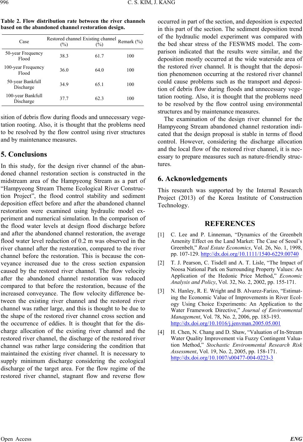
Table 2. Flow distribution rate between the river channels
based on the abandoned channe l restor ation design.
Case Restored channel
(%) Existing channel
(%) Remark (%)
50-year Frequency
Flood 38.3 61.7 100
100-year Frequ en cy
Flood 36.0 64.0 100
50-year Bankfull
Discharge 34.9 65.1 100
100-year Bankfu ll
Discharge 37.7 62.3 100
sition of debris flow during floods and unnecessary vege-
tation rooting. Also, it is thought that the problems need
to be resolved by the flow control using river structures
and by maintenance measures.
5. Conclusions
In this study, for the design river channel of the aban-
doned channel restoration section is constructed in the
midstream area of the Hampyeong Stream as a part of
“Hampyeong Stream Theme Ecological River Construc-
tion Project”, the flood control stability and sediment
deposition effect before and after the abandoned channel
restoration were examined using hydraulic model ex-
periment and numerical simulation. In the comparison of
the flood water levels at design flood discharge before
and after the abandoned channel restoration, the average
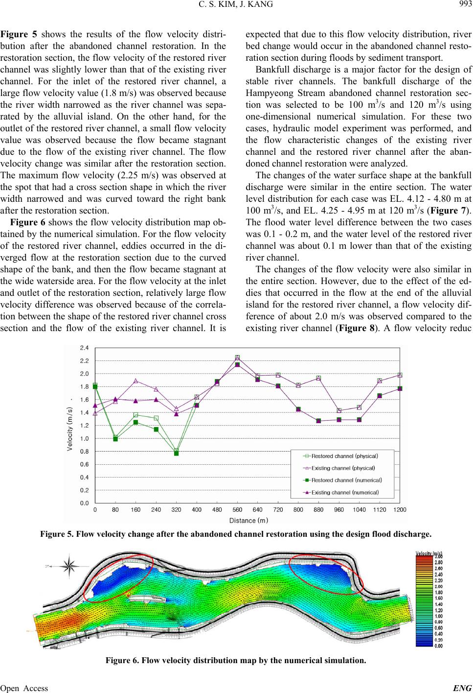
flood water level reduction of 0 .2 m was observed in the
river channel after the restoration, compared to the river
channel before the restoration. This is because the con-
veyance increased due to the cross section expansion
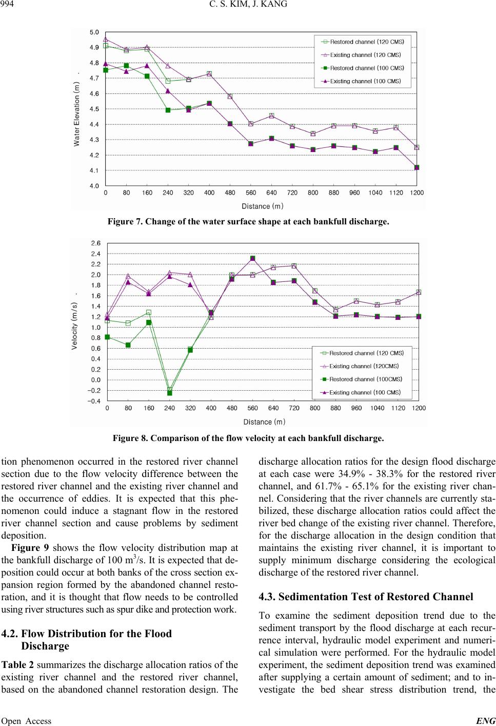
caused by the restored river channel. The flow velocity
after the abandoned channel restoration was reduced
compared to that before the restoration, because of the
increased conveyance. The flow velocity difference be-
tween the existing river channel and the restored river
channel was rather large, and this is th ought to be due to
the shape of the restored river channel cross section and
the occurrence of eddies. It is thought that for the dis-
charge allocation of the existing river channel and the
restored river channel, the discharge of the restored river
channel was rather large considering the condition that
maintained the existing river channel. It is necessary to
supply minimum discharge considering the ecological
discharge of the target area. For the flow regime of the
restored river channel, stagnant flow and reverse flow
occurred in part of the section, and deposition is exp ected
in this part of the section. The sediment deposition trend
of the hydraulic model experiment was compared with
the bed shear stress of the FESWMS model. The com-
parison indicated that the results were similar, and the
deposition mostly occurred at the wide waterside area of
the restored river channel. It is thought that the deposi-
tion phenomenon occurring at the restored river channel
could cause problems such as the transport and deposi-
tion of debris flow during floods and unnecessary vege-
tation rooting. Also, it is thought that the problems need
to be resolved by the flow control using environmental
structures and by maintenance measures.
The examination of the design river channel for the
Hampyeong Stream abandoned channel restoration indi-
cated that the design proposal is stable in terms of flood
control. However, considering the discharge allocation
and the local flow of the restored river channel, it is nec-
essary to prepare measures such as nature-friendly struc-
tures.
6. Acknowledgements
This research was supported by the Internal Research
Project (2013) of the Korea Institute of Construction
Technology.
REFERENCES
[1] C. Lee and P. Linneman, “Dynamics of the Greenbelt
Amenity Effect on the Land Market: The Case of Seoul’s
Greenbelt,” Real Estate Economics, Vol. 26, No. 1, 1998,
pp. 107-129. http://dx.doi.org/10.1111/1540-6229.00740
[2] T. J. Pearson, C. Tisdell and A. T. Lisle, “The Impact of
Noosa National Park on Surrounding Property Values: An
Application of the Hedonic Price Method,” Economic
Analysis and Policy, Vol. 32, No. 2, 2002, pp. 155-171.
[3] N. Hanley, R. E. Wright and B. Alvarez-Farizo, “Estimat-
ing the Economic Value of Improvements in River Ecol-
ogy Using Choice Experiments: An Application to the
Water Framework Directive,” Journal of Environmental
Management, Vol. 78, No. 2, 2006, pp. 183-193.
http://dx.doi.org/10.1016/j.jenvman.2005.05.001
[4] H. Chen, N. Chang and D. Shaw, “Valuation of In-Stream
Water Quality Improvement via Fuzzy Contingent Valua-
tion Method,” Stochastic Environmental Research Risk
Assessment, Vol. 19, No. 2, 2005, pp. 158-171.
http://dx.doi.org/10.1007/s00477-004-0223-3
Open Access ENG