Current Urban Studies
Vol.06 No.03(2018), Article ID:87207,35 pages
10.4236/cus.2018.63020
Planning the Intermediate City, or How to Do Better with Little: The Case of the City of Nueve de Julio, Argentina
Jean Claude Bolay
CODEV (Center for Cooperation and Development) & LaSUR (Urban Sociology Laboratory), EPFL (Swiss Federal Institute of Technology, Lausanne), Lausanne, Switzerland

Copyright © 2018 by author and Scientific Research Publishing Inc.
This work is licensed under the Creative Commons Attribution International License (CC BY 4.0).
http://creativecommons.org/licenses/by/4.0/


Received: July 19, 2018; Accepted: September 8, 2018; Published: September 11, 2018
ABSTRACT
With 92% of its population living in urban areas, Argentina is one of the most urbanized countries on the planet. Like in many South Countries, the populations of the small and medium-sized cities, which serve as intermediate centers between the countryside and the urban network, are growing steadily. Such cities in Argentina offer services and infrastructures to both urban and rural populations, as well as a residential alternative to the Greater Buenos Aires metropolitan area. These cities, however, are facing specific problems that require appropriate responses. In this respect, Nueve de Julio is emblematic of the challenges facing these intermediate cities. As one of the hundred cities created in the 19th century by the Argentinian government, Nueve de Julio is today a city whose population is increasing, and territory is expanding, but that lacks any foresight to anticipate the next 20 or 30 years. Our purpose is to analyze the reasons of this stagnation, explain the serious development problems the city confronts, with disparities in the organization of its territory and 20% of population living in poverty, and foresee an open system of urban planning, capable to guide the urban authorities and its partners in the identification of priorities and investments in favor of all the inhabitants. The government seems helpless in dealing with this. Political activism prevails over planning and varies from one election to the next depending on the party in power. Means are lacking, both financially and in terms of technical skills. Establishing an open system of urban planning is imperative. Based on the collaboration of citizen, the goals of the planning should include social, economic and spatial integration, efforts to include the city’s poor and more rational, less costly development of the suburban periphery. This will enable Nueve de Julio to better play its role as an intermediate city for the entire urban and regional population with regard to business, administration, education and health services.
Keywords:
Intermediate City, Ordinary City, Medium Sized City, Urban Growth, Urban Planning, Urban Poverty, Cooperative of Services, Nueve de Julio, Province of Buenos Aires, Argentina

1. Introduction: An Ordinary Intermediate City
Nueve de Julio is undoubtedly a rather “ordinary” intermediate city, like hundreds of others throughout Argentina and Latin America. Beyond the immediate influence of Argentina’s sprawling capital, it is one of the hundred new towns built during the 19th century by the Government of Argentina to reinforce the country’s colonization and encourage agriculture and export breeding. As a medium-sized city in terms of its population size and surface area, it is also an intermediate city in that it establishes an important link between the rural economy and the public services required by the regional population. Nueve de Julio thus seems like a quiet, carefree city of 50,000, with a shopping area, health institutions and a focus on education facilities.
However, in the past 30 years, its population has grown rapidly and its inhabited territory expanded exponentially, like other similar cities of the pampas region. These changes have taken place in parallel with policy changes at the national level, as well as political changes in communal governance, and they are impacted by a globalized economy that dictates the price of raw materials and consumers products. During a collaborative scientific program with the local government of Nueve de Julio, we had the opportunity to reflect on the shortcomings in the city’s urban planning and their impact on the city’s organization and the population’s social and economic integration. In what way is Nueve de Julio an “ordinary” city whose characteristics are reproducible in other cities in South America? And what can we learn from its mode of governance in terms of urban development that targets both sustainability and inclusiveness―like that promoted by international organizations? The concepts of “ordinary city” and “intermediate city” will guide us in our initial diagnosis of urban planning and governance in Nueve de Julio.
2. Argentina: One of the Most Urbanized Countries in the World
According to Figure 1 from the World Bank1, in 2015, the urban population of Argentina represented 92% of the country’s 40.1 million people, or 6.8% of the population of Latin America, making it the 4th most populous country on the sub-continent after Brazil, Mexico and Colombia.

Figure 1. Argentina―Population density (Source: Ministry of Education2).
In Argentina, any locality with more than 2000 inhabitants is considered an urban settlement (Pellegrini & Raposo, 2014) . According to Velásquez (2013) and the Ministry of Planning’s (2011, III) population censuses, urban growth has continued uninterrupted since the late 19th century (1895: 37%, 1914: 53%; 1947: 62%, 1960: 72%, 1980: 83%, 1990: 86% and 2000: 90%). Hence, Argentina is one of the most urbanized countries in the world, surpassing both European (74% in 20173) and United States (82% in 20174) averages.
At the national level, it is interesting to consider experts’ analyses of historical trends in Argentina’s urbanization process.
Buenos Aires’s urban primacy has been prevalent since the 18th century. This can largely be explained by Argentina’s position as a major agro-exporter, and as an industrial investment area starting in 1937, with Europe on the brink of armed conflict. Starting in the 1970s, this import-substitution model, which led to the spread of Buenos Aires’s metropolitan area and the development of large agglomerations like Rosario and Cordoba, was challenged by the political changes imposed by the military dictatorship. “Greater Buenos Aires,” the majority of whose population lives in the State of Buenos Aires that surrounds the national capital, was still home to 50% of the Argentine urban population at that time. As Ainstein (2012) explains, Argentina’s urban expansion has been marked by the waning primacy of Buenos Aires and several other large Argentine cities. The Greater Buenos Aires’ population thus totaled 37.2% in 2002. However, the unemployment rate has also increased, as has the rate of informal employment. The poor population increased from 5% in 1980 to 51.7% in 2002 (Portes & Roberts, 2005) .
Buenos Aires’ dominance extends over the nearby pampas region, which is the main growing and cattle breeding area, specific to Argentina’s chosen agro-export system. In 1947, most of the country’s medium-sized cities were located there. According to the 2010 census, while this urban concentration continues and includes more than 50% of medium-sized cities, it is now more diffuse. Hence, cities are now scattered throughout the country’s provinces. Today, the most marked urban growth can be found in medium-sized cities (Manzano & Velazquez, 2015) . Lindemboim & Kennedy (2003) confirm this trend towards small and medium cities. They conclude that, from 1960 to 2000, Greater Buenos Aires and the Pampas region―the country’s two most populated areas―were also those whose urban growth was the most moderate compared to the country’s other regions. In addition, like the federal capital, slower growth can be observed in Argentinian cities with more than 500,000 inhabitants. According to these experts, it appears that, since the 1970s, the urban population of cities with 5000 to 500,000 inhabitants has grown faster than the national average. For them, from 1960-2000, the dynamics of the urban population saw a double decline: that of cities’ population size and that of their geographical location. Regarding the first, municipalities on the outskirts of large agglomerations started seeing their population increase the most as early as 2000. For the second, medium-sized towns outside the pampas region are those that seem to be the most attractive, and whose populations are growing fastest.
Nowadays, urbanization in Argentina is marked by low population densities and a wide dispersion of settlements relative to the pre-existing urban fabric. Thus, it is expected that, between 2000 and 2030, the urban population of cities of more than 100,000 inhabitants will increase by 72%, while the inhabited area will grow by 175%. With 862 cities of more than 2000 inhabitants, urban areas in Argentina can be divided into several categories: first, there is the international pole (to use the Federal Planning Ministry’s expression) of Greater Buenos Aires and its 13 million inhabitants (40.3% of the urban population). This is followed by four large urban agglomerations that represent national nodes―Cordoba, Rosario, Mendoza and San Miguel de Tucuman (12.9% of the urban population). These are followed by regional nodes (18 cities with an average population of 280,000, representing 15.7% of the urban population), followed by sub-regional nodes (82 cities with a population of 52,000, representing 13.3% of the total urban population) (Ministerio de Planificación Federal, Inversión Pública y Servicios, 2011b) .
The country’s central region, of which the federal capital and the province of Buenos Aires are its heart, is therefore the only one whose cities are represented at all levels of urban hierarchy. This is characterized by a high-density urban network and a clear distinction between the highest level (identified in the Buenos Aires metropolitan area, as we can see on the Photo 1) and subsequent levels like La Plata (the capital of the Buenos Aires Province) and the other agglomerations. These areas have highly dense road and rail networks, active medium-sized towns and numerous small, generally well-equipped regional urban centers. As illustrated on the photo, the Buenos Aires metropolitan area (the Gran Buenos Aires, in Spanish) is the most densely populated region of Argentina, consisting of the national capital and 24 suburban municipalities. With a population of more than 12.8 million inhabitants and 4.08 million households on an area of 3.833 km2, this urban region hosts 31.9% of the national population5.
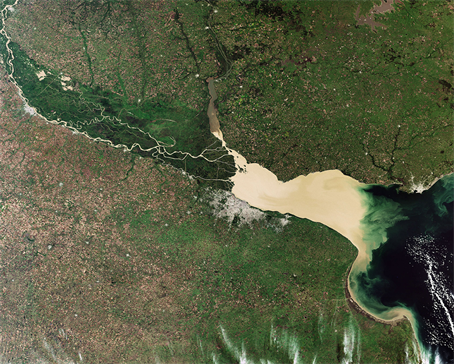
Photo 1. Greater Buenos Aires metropolitan area (Source: satellite photo, Spotlight, 20096).
This population dynamic of medium-sized cities in Argentina brings new challenges in terms of development and investment in infrastructure and amenities. Since the 1990s, the infrastructure and public service supply is no longer consistent with urban growth, due to the neo-liberal economic policies of successive governments. The state of the roads is deteriorating, as are the drinking water and wastewater evacuation networks. This is particularly true in the outskirts of large cities and the municipalities that comprise Greater Buenos Aires (Bolay et al., 2004a, Dubois Maury, 1990) . Until the 1990s, no national planning law or building code existed; everything depended on the provinces, with numerous delegations at the municipal level (Dubois Maury, 1990) . Concretely, this superposition of local and provincial regulations gives rise to numerous derogations. The often random nature of urban development projects, regardless of the sector, entails the risk of a lack of a broader, more comprehensive vision, and thus deviates from longer-term planning goals.
In 2004, the national government created the Secretariat for Territorial Public Investment Planning within the Ministry of Federal Planning (MPF, 2011a: I) , which establishes the State’s planning role and promotes territorial development as a capacity-building process to guarantee each province’s ability to ensure a sustainable mode of social and economic well-being for the communities living there. This involves consultation with civic actors and the granting of federal funds. From this was born the “Urban Argentina” Program in 2008, and later the concept for the Territorial Strategic Plan (PET) in 2016. The supervisory ministry’s objective was to establish public policies that do not focus on large metropolitan areas only, but medium-sized cities as well. In terms of risks and opportunities, we effectively lack information on this type of city, though we know that medium-sized cities’ populations are growing the fastest.
Following this blueprint, each small or medium-sized city is now better placed in a web of communications with other cities, while maintaining a functional relationship with the surrounding rural environment. In reality, their future is increasingly dependent on decisions made by a multitude of actors at different scales (local, provincial and national). As such, their regional and national integration largely depends on the link between existing and future infrastructures (roads, transportation systems, telecommunications/computer networks, etc.). This must also be considered in a context of urban-rural and interurban interplay characterized by increasing geographical mobility, along with complex residential and professional situations (e.g. working in Buenos Aires and regularly commuting to cities outside the metropolitan area, or working remotely via ICT for companies in the capital, but making periodic face-to-face visits). Such compromises help make “provincial quality of life” and urban economic integration compatible.
Given the emergence and establishment of new business sectors such as tourism and high-tech enterprises, these small and medium-sized Argentinian cities are being pulled into dynamics that are sometimes quite integrative at the regional and national levels, but that also must deal with processes of social and/or economic exclusion. Lan, Adriani, & Savério Sposito (2018) remind us that intermediate cities’ dynamics are also the result of the strategies of major industrial groups who tend set up their production units in intermediate cities, where land and labor costs are cheaper and profits are higher.
Coming back to Argentinian urban dynamics and the changes taking place in the small and medium-sized cities that serve as intermediaries between rural hinterlands and urban networks (Bolay & Kern, 2018) , it appears that Argentina’s recent urbanization resembles that of Western industrialized countries. This is largely due to the fact that residential choices are no longer made based exclusively on job location. Communication and transportation networks have also greatly facilitated commuting. It is in this way, and based on the example of Nueve de Julio and other Latin American cities, that we can observe how regional urban centers―though somewhat modest at the national level―nonetheless serve as intermediate centers for their hinterlands and provinces (Bolay et al., 2004b; Bolay & Rabinovich, 2004a) . Such cities emphasize the quality of life and safety, and offer a lower cost of living. This also applies to the Buenos Aires Province, one of the most densely populated regions of one of the most urbanized countries in the world, and a world leader in terms of advanced agricultural techniques and exportation (Gorenstein et al., 2007) .
3. The Province of Buenos Aires: A Dense Territory under Influence
The Buenos Aires Province is an immense territory of some 300,000 sq.km, the equivalent of 11% of the national territory―the surface area of Italy! This largely endless plain, which encompasses most of the Argentinian pampas7 (Pesoa Marcilla, 2016) , is the country’s most populated region. Its estimated population of 16.65 million in 2015 was spread over 109 municipalities8, and represented 39% of the national population. This, of course, includes much of Buenos Aires’ metropolitan area, and 7.2% of the same national population within its administrative boundaries (INDEC, 2012) . The metropolitan area of Buenos Aires, often called Greater Buenos Aires, is comprised of the capital (2.89 million residents) and 24 peripheral municipalities located within the province of Buenos Aires. In 2010, this metropolitan area was home to an estimated 12.8 million people9.
The province of Buenos Aires contributes 36% of Argentina’s gross domestic product (GDP) (Ministerio de Economía, 2012) . The main economic sectors are industry (26.9% of national production), transportation (17.3%), real estate (13.3%), trade (12%), tourism (7.8%) and construction (5.8%). While the agricultural sector, which is financially dependent on commodity prices on the international markets (notably soybean), accounts for only 4.3% of the province’s output, it has been steadily strengthening since the early 2000s. Growing areas grew by 34.8% between 2003 and 2011, from 22.5 million acres to 52.6 acres. Soybeans are the main crop, with close to 14.8 million acres, followed by wheat, maize and sunflowers. The Buenos Aires Province’s economy accounted for 33% of Argentina’s exports to the world in 2015, versus 49% in 199710.
There are 67 rural municipalities in the Buenos Aires Province with a population of approximately 1.3 million, representing 10% of the provincial population (27% excluding the metropolitan belt). The 42 urban municipalities are home to 3.5 million residents outside of the Buenos Aires metropolitan area. The fastest-growing municipalities in terms of population are those that are part of the Greater Buenos Aires metropolitan area and those along the coast.
According to the 2010 population census (INDEC, 2012) , the 109 municipalities in the Buenos Aires Province were comprised of: the capital (La Plata) with 649,613 residents, followed by 10 municipalities of more than 100,000 inhabitants, 17 municipalities of 50,000 - 99,999 inhabitants, 37 communes of 20,000 - 49,999 inhabitants, 30 communes of 10,000 - 19,999 inhabitants, and the remainder comprised of smaller communes. The population density for the Buenos Aires Province is translated on Figure 2.
The Province’s colonization has its roots in the quest to conquer the national territory in the early 19th century, with the aim of making Argentina a “truly” developed, exploited country, as shown in Figure 3. In keeping with Pesoa Marcilla’s analysis (2016) , this strategy was based on a variety of initiatives in the field, ranging from the enactment of land ownership laws to regional immigration regulation, wars and peace treaties with indigenous populations, the founding of villages and cities, and even the creation of a national mapping institute. For the leaders at that time, the objective was to “civilize” the country by incorporating fertile lands (then occupied by indigenous peoples) into the national production system, thus enabling an increase in the production of cattle and grains (Ratto, 2003) .
What emerged as a result are the more than hundred new cities―mostly built between 1850 and 1916―founded in the Buenos Aires Province, which makes it unique at the global level, for such a short historical period and so vast a territory.
In keeping with an agrarian economy largely comprised of livestock and cereal crops, each new agglomeration’s urban center was bordered by concentric growing areas (Pesoa Marcilla, 2014) 11. Each urban plan was geometrically and rationally organized around a town square (local government buildings, church, school, bank, theater, etc.) and its purlieu into “manzanas” (Pesoa Marcilla, 2012) . The precise organization of these new cities concretely conveys the priorities of these new settlements, which were gradually linked to one another and

Figure 2. Population density for the Buenos Aires Province, Argentina (Source: Provincia de Buenos Aires, 2010).
the national capital by rail and road. The Province’s proactive urbanization policy clearly reflects the will of a landowning oligarchy that was not affected by regional conflicts in a country emerging as a major exporter of raw materials of rural origin on the world market. The goal, therefore, was to be an actor in the construction of modern Argentina and its institutions in a larger process of conquering exploitable lands (Segura, 2009) .
The region’s first foreign residents at that time were immigrants of Italian, Spanish, Basque and French origin, coinciding with the massive wave of immigration in the 19th century linked to the agro-export model of meat, milk and grains to Europe (Aliandri, 2015) .
Closer to home historically, it appears that since the 1960s, the suburban municipalities of Greater Buenos Aires now represent the majority of the Province’s population and is increasing. It accounted for 55.8% of the provincial population in 1960, and 63.5% in 2010, or two-thirds of the total population. Outside of this metropolitan area, medium-sized cities of more than 10,000 inhabitants have the fastest growing populations. There were 69 such cities in 1991. In 2000, this figure rose to 76, including 21 cities of more than 50,000 inhabitants.
According to the nomenclature developed by the MPF (2011b) , the urban agglomerations of the regions and provinces are defined according to three categories that characterize the major economic trends of each city: a production function, an intermediation function and a reproduction function. Differences in terms of infrastructure and services also set the cities of the Buenos Aires Province apart, as does public transportation. According to the 2001 census (MPF, 2011a) , it appears that cities in the lower strata of the urban hierarchy do not have public transportation services, whereas sub-regional urban nodes and agglomerations of more than 50,000 inhabitants all do.
The medium-sized cities of the province of Buenos Aires’s pampas region undoubtedly serve an intermediate function at the regional level as businesses and services centers directly related to the rural population and the province’s agro-industrial production. They are also logistic hubs administratively and governmentally, as well as investment places for certain agricultural incomes (real estate, land, commercial, etc.), bearing in mind that it is the province’s main job market. Linking the Buenos Aires Province’s territorial organization to its economic development, Gorenstein et al. (2007) put forward the concept of neo-rurality, which is useful in going beyond the rural/urban dichotomy, especially through the multifunctional nature of jobs held by rural dwellers and based on the increasingly intermediary role the province’s urban centers play relative to the surrounding countryside, as in most South countries (Bolay & Rabinovich, 2004b) .
4. Nueve de Julio: Urban Growth under Pressure
4.1. Nueve de Julio: What Intermediate City for the Region?
Let us recall that, in our analysis, intermediate cities are characterized as much by their functions as by their dimensions, be they territorial or demographic (Bolay & Kern, 2018) . In order to refine our analysis of Nueve de Julio and its roughly 50,000 inhabitants, we will evaluate its development potential based on the interactions between the city and its environment.
With a dual problem of size and resources, Nueve de Julio lacks human and financial means, as well as the institutional capacity to anticipate its rapidly growing population and manage its impact on the occupation and organization of the territory.

Figure 3. Founding of cities in the Buenos Aires Province in the 19th century (Source: Pesoa Marcilla, 2012 ).

Figure 4. (Source: Chart by J.-C. Bolay, according to 2017 population censuses (INDEC) and estimations).
The creation of the city of Nueve de Julio on the shores of three lakes dates back to 1863, and was part of politicians’ and military leaders’ strategy to conquer the Argentinian territory. The city is located in the central northeastern part of the Buenos Aires Province, at 76 meters above sea level (35˚27'S latitude and 60˚53'W longitude), 262 kilometers from the federal capital. Its surface area is 1,045,256 acres, 963,711 of which are dedicated to agricultural production and livestock12. The aerial view of the city of Nueve de Julio is on Photo 2.
According to the most recent population census (2010), Nueve de Julio’s population (the partido, meaning the municipality’s urban center and the rural territory) reached 47,733 inhabitants in 2010, 36,494 of who lived in urban areas. According to the municipal authorities (but with no official source of reference), the 2017 estimate was roughly 52,000 (the demographic evolution is shown in Figure 4). This indicates that the population has grown faster over the past decade, given that the city already had 45,998 residents in 2000 (with 34,350 in urban areas) and 44,021 in 1990 (with 30,356 in urban areas). In a span of 20 years, between 1990 and 2010, the communal population grew by 8.43%, from 44.021 to 47.733. During this same period, Nuevo de Julio’s urban population increased by 20.22%, from 30.356 to 36.494. If one gives credence to the words of local councilors and their estimates regarding the current population, the current decade has been marked by a demographic upsurge that started in 2010 and would reach 52,000 in 2017 (8.9% population growth in 8 years!).
Given this, municipal urban planning leaders have identified several priority issues. The first is controlling the city’s territorial expansion as a result of its ever-growing population, with human settlements increasingly spread out and distant from the historical center. Doing so means reinforcing the urban network by creating areas that serve specific functions (housing, industry, nature reserves, etc.). The other is meeting the basic needs of the city’s most destitute population. In this case, the focus should be on the “Ciudad Nueva”13 area, the city’s most unstable neighborhood (12,000 inhabitants), where infrastructures, housing, water supply and drainage networks (to fight against floods) must all be improved.
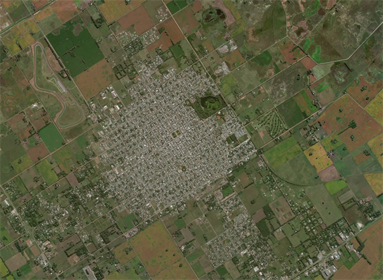
Photo 2. Aerial view of the city of Nueve de Julio (Source: Google Maps, 2018).
4.2. Nueve de Julio: An Ordinary Modern City in the Argentinian Pampas
J. Robinson’s work on South cities teaches us that, rather than compare urban realities based on clearly identified criteria, theoretical assumptions have ordered and locked cities into models that do not fit them: rich cities versus poor cities (but where are the boundaries?) and South cities versus North cities (but where are Argentinian cities in this binary vision of urban development?) (Robinson, 2011) . This is all the more true in a globalized world that, as the author aptly puts it, faces “… growing assertions of convergence and connections across urban experiences in a globalized world―ranging from globalizing formal economic networks to transnational networks of design, policy, culture and governance...”) (Robinson, 2011: p. 5) . Therefore it is less a question of urban modernity versus urban development promotion, to use the words of Kern (2017) , which underpin our analysis, than of constitutive elements of urban identity. In many parts of the global South, urban economies are dominated by the informal sector.
The example of Nueve de Julio puts us face to face with a completely different Argentinian reality, through planned cities built based on formal and legally-recognized systems of economic production, whose prosperity largely depends on international connections of supply and the distribution of goods and raw materials. In this respect, urban sprawl in Argentina―which is recent for much of the Buenos Aires Province―relates more to the analysis of new cities created in the 19th century following a European model and implemented in Latin American. Understood in terms of their similarities and differences, these South cities cannot be excluded from the analysis, as they are but one manifestation of the global urbanization process among others (Robinson, 2006; Schuermans, 2009) . Understanding the role of an intermediate city like Nueve de Julio brings us back to Fraser’s observations. For him, the concept of ordinary city “... provides readers with an invigorated call to develop a post-colonial urbanism that is cosmopolitan in the sense of conceiving all cities as sites of modernity. This does not diminish the stark differences between places that are differentially connected to networks across the globe, and it does not ignore the differential challenges cities face as a result of uneven development patterns and unequal resources” (Fraser, 2006: p. 196) . While it is certain that Nueve de Julio is not a global city by Sassen’s (2001, 2002) definition, with functions of monitoring and control over the internationalized economy, it is a mixture of modernity and tradition, and is likewise a part of this globalized market economy (Robinson, 2002) . Nueve de Julio is but one piece on an international chessboard of flows of raw materials and services, in service to Argentinian agro-export.
In light of this, and with the goal of better understanding Nueve de Julio’s current situation, certain elements of “modernity” and “development” set this city apart while, at the same time, harmonizing its trajectory with that of the Buenos Aires Province’s pampas region.
For the 150 years of its existence, Nueve de Julio has been highly representative of modernity in dealing with the world, the fruit of the technological and social advances that have shaped both Europe and Latin America: human migration from Europe to Argentina, accelerated industrialization of primary and secondary production, and financial gain from an export economy. Velásquez (2013) confirms that, in the 19th century and more notably the 20th, the Pampas region’s medium-sized cities greatly benefited from this agro-export model (Europeanized urban society, generalized wages and social integration). Things started changing in the 1970s, with more marked socio-economic differences and social exclusion of large segments of the population. Nevertheless, Greater Buenos Aires and the Pampas region (and the province of Buenos Aires in particular) are still the areas where industry prevails, favoring urban growth. “... Argentina is typical of a manufacturing country with a center in the metropolitan area of Buenos Aires, an inner belt formed by the most industrialized Pampas provinces and an outer belt with the rest of the country” (Platino & Pellegrini, 2016: p. 109) .
4.3. Nueve de Julio: Fragmented Modernity between Territorial Expansion and Social Inclusion
In recent history, Nueve de Julio has faced problems similar to those found in most of the Province’s medium-sized cities, but with undeniable prosperity that is reflected in territorial planning (e.g. the central square or General San Martin Park, as shown on Photo 3). Prosperity and growth cannot be guaranteed over time, however, as the city’s growth largely depends on the vagaries of the agro-production sector and fluctuations in the global market for raw materials and agro-food products. Moreover, since the population is growing, many urban dwellers are now attracted to this type of city, which some feel offers a viable alternative to the density of Greater Buenos Aires. These new residents have individual, family and social needs, be it in terms of professional integration, education or health. Yet, the government’s response to the needs of Nueve de Julio’s 50,000 or so inhabitants seems insufficient, or at the very least raises questions as to what the priorities should be in terms of future urban projects.
Social and economic figures and data pertaining to Nueve de Julio are almost impossible to find directly, in documents relative to these aspects of the city, or indirectly, via the Internet.
What is accessible on the Municipality of Nueve de Julio’s website is the municipal budget for recent years, with receipts and expenses, which provides an initial overview of local public action. The estimated budget for 2017 was 712.62 million pesos, the equivalent of roughly 35 million US dollars14. Over 323 million pesos were allocated to municipal staff, and 21 million to debt service. The main areas of expenditure were: core activities (supposedly related to municipal services) at 144 million; the maintenance of public roads at 127 million; the development of primary health care policies at 52 million; collaborative works with the CEYS cooperative at 45 million; the maintenance of municipal and provincial roads at 44 million, and urban and community hygiene services at 42 million. This was followed by budget allocations (20 - 30 million) for items such as education and youth services, safety, buildings and public spaces, reforestation, green spaces and insect control. In fact, according to municipal information provided in 2018, the actual budget was somewhat lower; according to them, national, provincial and communal funding totaled 570 million pesos.
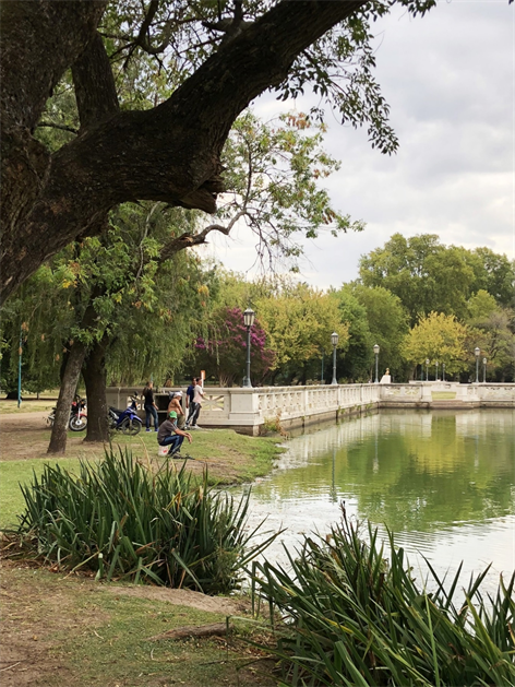
Photo 3. General San Martin municipal park (Source: Photo J.-C. Bolay, 2018).
Browsing Nueve de Julio’s online press, several insights provide additional information regarding the region’s economic situation, albeit in a piecemeal way. According to the head of the Chamber of Commerce, the local economy is stable but lacks real growth, and is entirely dependent the revenues from the 2016-2017 agricultural harvest. Inflation, which is still poorly controlled at the national level, weighs heavily on local entrepreneurs. To his mind, the often evoked idea of an industrial park would energize the city’s and region’s economy15. According to another private source quoted by the same newspaper, new jobs in Nueve de Julio in 2017 increased by 30% relative to 2016, mainly in the areas of services, business, administration and sales, and mainly benefit higher education professionals16.
The picture would not be complete were we not to highlight one of Nueve de Julio’s particularities which, like other cities in the Buenos Aires Province, organizes community services in joint-management with the “Cooperativa Eléctrica y de Servicios Mariano Moreno Ltda”. The latter currently has 21,000 partners for the distribution of electricity, 12,900 for natural gas and 8300 in mobile telephone and internet access (see workers of the CEyS on Photo 4). According to its manager17, all of Nueve de Julio’s households are affiliated with the cooperative, thus giving him extremely detailed knowledge of the local population and its needs. The origins of the cooperative date back to the 1920s, when Nueve de Julio’s inhabitants, faced with the poor quality and exorbitant cost of electricity, decided to produce their own energy. Hence, the first popular electric plant was built in 1949. With the years came other services to complete the offer: street paving in 1972, natural gas in 1989, running water in suburban localities, ambulance services, health insurance, funerals and burials, consumer loans (since 2007), and in 2010, Internet and mobile phone connections.
A collaborative agreement exists between the municipality of Nueve de Julio and the Cooperative. However, it goes without saying that relations have fluctuated over time, and depending on the political tides. Over the past two years, the election of a new political majority and a new mayor from the presidential majority party (the republican PRO) has put some strain on relations with the Cooperative which, traditionally, has been radically obedient. In 2018, after 13 years of unopposed cooperative management, elections were held to renew the CEyS’s board of directors. Victory went to the “democratic transparency” list18, making negotiations between the Cooperative and the municipality inevitable. Though unable to prove it for lack of access to information, but based on the comments from the field, an unusual competition exists between the two institutions, with the CEyS generally seen as an historically-rooted organization that manages large swathes of urban development and that works both collectively and privately for all of the municipality’s residents. It is recognized for its administrative and financial rigor, as well as its efficiency in the production of goods and services, but is criticized by some for its monopolistic tendency to manage all profitable utilities. Municipal services, on the other hand, are criticized first and foremost for the instability of the political changes, the poor management of civil servants, and their material and logistical shortcomings. What characterizes municipal action above all is its ideological slant and its political impact from one election to another, having neither the means to fulfill its ambitions nor a long-term vision of the city’s and region’s future.
One must see this association as historically being somewhere between the municipality and the Cooperative, bearing in mind that cooperatives have had a strong presence in Argentina since the 19th century, and that the province of Buenos Aires is, by far, the region with the greatest number of them: according to Montes & Ressel (2003) , in 2003, 4498 of the country’s 16,000 existing cooperatives were active in the province. Of these, 624 provided services to the community. According to Centro Cultural de la Cooperación, at the national level, the cooperative sector generates 10% of the GDP and 500,000 jobs. In terms of public services, cooperatives supply water and gas, produce energy (often renewable), and distribute it to consumers in over 1500 municipalities of various sizes throughout the country19. Although cooperatives are a recurring phenomenon in Argentina, they are infrequently studied. We know little about the impact of this public-private partnership in development planning and the power struggles they give rise to in strategic decision-making for cities.
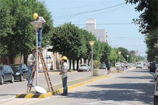
Photo 4. CEyS personnel repairing street lamps (Source: DiarioTiempo Digital, January 7, 2018)20.
4.4. Daily Disturbances: Nueve de Julio and Its Planning Issues
During our interviews with the mayor and Nueve de Julio’s director of urban planning, the big question―which subsequently became the subject of a collaborative agreement between the Municipality and the EPFL’s Center for Cooperation and Development21 (CODEV)―was urban planning or, more specifically, the lack thereof. What notably was missing was data that would allow for a “status report”, making it possible to trace the city’s evolution in its various territorial and societal dimensions in order to develop a realistic, tangible master plan. The question may seem surprising coming from the authorities of a medium-sized town that, at first glance, seems relatively well-organized and esteemed by its inhabitants. But facts have confirmed these shortcomings of the planning, leading us to make an initial diagnosis with regard to urban planning, and to define the various stages of a procedure to collect, archive and process useful data in an organized way in order to establish a basis for planning based on credible, transparent figures using a Geographic Information System (GIS).
The first observation was that existing data is not shared between the CEyS Cooperative and the Municipality, even less so as the cooperative subcontracts the harvesting and processing of data to a private company that archives the information and produces summaries. Secondly, the Buenos Aires Province’s administration, like the competent national departments, also manages statistical data relating to the city of Nueve de Julio as it does for all of the province’s other municipalities. However, this data may not be accessed by the public. Moreover, the many requests made by the Municipality have remained unanswered! Here one can clearly appreciate the importance and utility of collaborative efforts to be made by the Municipality and the Cooperative. The Cooperative indeed has a great deal of data pertaining to its customers. Moreover, its customer base, whose electricity, natural gas and other utilities it supplies, is close to that of the municipal population. If made available to the City, this information could provide a solid, reliable basis for sound and dependable planning.
This does not mean that communal departments have no data, but rather that there is no coherent, organized way of sharing information internally among the different departments, or between the State administration and its outside partners, which are mainly cooperatives.
What has been acquired and is managed by Nueve de Julio’s Secretariat of Housing and Urbanism is the city code and the resulting zoning, which integrates parcels of land, thus sketching the lines of growth for the city and priority actions according to the zone, including the services and infrastructures the city wants to bring to the various districts. Based on these official documents, it appears that the number one priority for the local authorities is the historical center (referenced as residential (R1)) and the more recently-built concentric residential areas (R2). The second priority in terms of public intervention is the residential growth areas located southeast and northeast of the city (R3 and R4). In third position comes the rehabilitation of the “Barrios Unidos” neighborhood (formerly Ciudad Nueva) (R5), the poorest part of the city as mentioned earlier, and the less densely populated outlying areas (R6). These subdivisions appear on Figure 5. Concretely, this means that solving the problems of the poorest 25% of the Municipality’s population is not a priority in the physical layout of the city. Yet, this clearly contradicts the statements of high-level local administration officials. An upgrade in either the official discourse or in the plans is long overdue.
The cadastral plan and special works department, which is part of the Secretariat of Urbanism, also has vital information regarding existing parcels of land, public properties, buildings and building permits. The problem is that this data still only exists in paper version. Much more data exists and would be highly useful for establishing a geo-referenced information system (clinics, hospitals, schools, public spaces, green areas, industrial zones, etc.). This data is collected


Figure 5. Areas map of Nueve de Julio (Source: Municipality of Nueve de Julio22).
and managed by various municipal administration departments, and is rarely updated. Other data regarding water networks, drainage, wastewater, gas and electricity simply does not exist. Moreover, there is no replication of the data managed by the CEyS Cooperative in the municipal departments.
The information is scattered and completely disconnected from each other. Due to a lack of time and human and financial resources, the Municipality, though aware of its obligation at both the national and provincial levels to look more closely into the plight of the poor, manages urban problems on a day to day basis, more in the reaction to events and to satisfy pressing social demands than to prevent and plan.
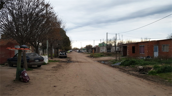
Photo 5. An outlying neighborhood of Nueve de Julio (Source: Photo by Teo Vexina Wilkinson, CODEV, 2017).
4.5. Ciudad Nueva, a Low-Income Area: Socio-Spatial Segregation?
It is astonishing to think that, in 1996, in anticipation of the World Habitat Conference in Istanbul, we published a comparative book to recap the traveling seminars we had organized with our Latin American colleagues, with the support of the Leopold Foundation Mayer for Human Progress (Bolay et al., 1996) . In this book, in which David Kullock and his colleagues at the Faculty of Architecture and Urban Design (FADU) of the University of Buenos Aires reported on the training that Nueve de Julio had provided its urban actor two years prior (Kullock et al., 1996) . Of the three Argentinian cities investigated at that time―Resistencia, San Juan and Nueve de Julio―the latter had 30,000 inhabitants, and the study area, “Ciudad Nueva”, was comprised of 371 acres in the southeastern part of the city, between the historic Sarmiento railway line and the national road No. 5 (see the urban zone of “Ciudad Nueva” in 2017 on Photo 5 and as it was in 1994 on Photo 6).
Railway workers had originally settled on the site. The population increased, building on plots of available land along the urban-rural boundaries. One characteristic of the urban planning is that land use is disparate and sparse, mixes housing and production units and creates spatial as well as social isolation from the historic city center due to the train tracks. In 1994, infrastructures and public facilities included water and electricity networks, natural gas in one of the zone’s four areas, and a public school. The streets were unpaved and without sidewalks. The majority of the houses were small and rudimentarily equipped. The recommendations that came out of the 10-day seminar focused on six elements to improve the area’s urban integration. These conclusions are still valid today, almost 25 years later. They included job creation, urban integration of neighborhoods, improving school and health services, rehabilitating existing housing, implementing building standards, and improving infrastructure and communication networks.
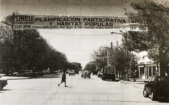

Photos 6. Nueve de Julio 1994: workshop on participative planning and popular habitat (Source: Archival photos, J.-C. Bolay, 1994).
Some 25 years later, a diagnosis of the same area of Ciudad Nueva allows us to compare the nature of the problems and the solutions envisaged.
Now more commonly referred to as “Barrios Unidos”, this area still lingers in the outskirts of the historic city, without the city having taken any real urban planning or management measures to reduce the physical breach created the railroad, which is still used for transporting goods (see the neighborhood on Photo 7 and map on Figure 6).
Surveys done in two of the area’s neighborhoods in 2017 and interviews with public officials reveal two crucial points socially speaking: as in 1994, the people interviewed complained about unemployment and the difficulty of finding a job. Many work sporadically, and usually undeclared. In terms of health, Nueve de Julio’s existing services no longer sufficiently respond to social demands. The
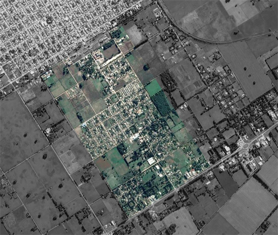
Photo 7. Aerial view of the Barrios Unidos area (Source: Google map, 2017).


Figure 6. Map of the Barrios Unidos, Nueve de Julio, Argentina (Source: Map produced by Teo Vexina Wilkinson, CODEV, 2017).
area lacks a health center as well as a 24-hour, on-call pharmacy. In terms of education, the dropout rate had increased; children could be seen wandering the streets, although the area’s only school functions normally (one public school for 10,000 inhabitants!). With regard to infrastructure and urban planning, respondents criticized the flooding and lack of wastewater drainage, the cause of the former. At the residential level, respondents made mention of the makeshift nature of many houses in terms of their construction. In addition to all of this, there was a feeling of insecurity, as the area is notorious for the traffic and consumption of narcotics.
This finding explains why the Community Development Secretariat has implemented a distribution plan for building materials for at-risk families. However, the demand is high, and the procedures long and complex.
More specifically, we conducted a building census in two blocks of houses, one a social housing estate with 28 family houses built in the 1990s, and the other with 50 private, self-built homes (Vexina Wilkinson, 2017) .
The social housing development had changed very little in terms of number of houses23. All of the homes had access to water, electricity and natural gas networks24, though only one street had a sewage system. The other houses were equipped with septic tanks that were emptied twice a month by a private company. The perceptible changes described by the owners depended on how the family’s economic resources had changed, and mainly concerned extension of the living space, changes in the internal layout of the living space and the acquisition of household electrical appliances. Given the poor quality of the construction and its age, the owners complained above all about the lack of insulation and resulting humidity.
The changes in the other block were more substantial. In 20 years, the number of houses had increased from five to 50. The constructions were more heterogeneous, though several makeshift homes (made of low-quality materials and with minimal implementation) were observed. The walls were made of bare brick, the roofs of polystyrene and cardboard boxes, and unprotected electrical wires were seen in the bathrooms. The differences from one dwelling to another reflect the financial capacities of each family over the years, bearing in mind that, according to their statements, none had received building materials from the municipality (2 types of housing rehabilitation can be seen on Photo 8 and Photo 9). In addition to these self-built plots, several vacant plots remained, along with a few plots with houses of significantly higher quality that were in excellent condition and supplied by the public gas network.
In most cases, the work done on the houses was done by the occupants themselves, without official authorization, which is formally granted by the public authorities after verification and application of norms.
The “Ciudad Nueva/Barrios Unidos” area has evolved in a very heterogeneous
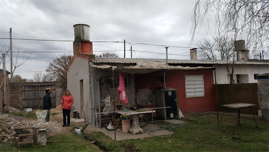
Photo 8. Barrios Unidos: rehabilitation of a house in a social housing development (Source: Photo Teo Vexina Wilkinson, CODEV, 2017).
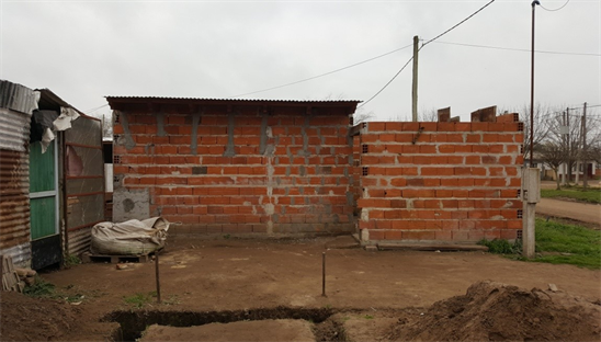
Photo 9. Barrios Unidos: rehabilitation of a house in a social housing development (Source: Photo Teo Vexina Wilkinson, CODEV, 2017).
way over the years, according to the district and the occupants’ means. In terms of housing, the changes that have taken place are the result of individual, private means, as few are eligible for loans. The municipal authorities’ only action, it seems, is its construction materials allocation program whose scale, beneficiaries, selection criteria, funding and debt collection processes are impossible to know.
The situation is better handled at the infrastructures level, as basic needs (water, electricity and gas) are covered by collective networks and, in part, by public facilities (school). “Ciudad Nueva” is still a stigmatized area whose standards as well as the reputation of the neighborhoods and its inhabitants are well below those of Nueve de Julio. The changes in the past 25 years are imperceptible. Generally speaking, it is those most in need who suffer the most from Nueve de Julio’s lack of a public transportation system.
The issue remains one of understanding how a city, its population, its authorities, its pressure groups and its professionals can be aware of this situation of true urban poverty, recognize that nearly 20% of the city’s population live in conditions of material instability and decide the measures to be taken... without it becoming a reality. There is no clear policy, strategy or master plan for the entire urban agglomeration. Nor is there an inclusive vision of the city―from a socio-economical or planning perspective―that focuses on the most disadvantaged populations and neighborhoods. This brings us to a final thought which concerns the uniqueness of Nueve de Julio as both exemplary of a contemporary intermediate Argentinian city and “ordinary” in its reproduction of a 19th-century model of urban modernism. Its challenge today is in overcoming its inability to acquire the right urban management tools for understanding the urban reality of today and projecting itself in a medium- and long-term future in order to decide on the priority actions to take, in dialogue with urban actors.
5. Discussion: What Direction for Nueve de Julio’s Urban Planning? Which Will Be More Suitable?
Beyond Nueve de Julio’s specific characteristics, its historical roots in contemporary Argentina and the practical management of its territory and population, an issue raised in other research works reemerges: that of urban planning and related institutional/social practices.
In two earlier urban investigations in Burkina Faso and Brazil, we had questioned the shortcomings in the implementation of planning processes (Bolay, 2016; Bolay, 2015) . Nueve de Julio raises a more original question: does urban planning make sense for an “ordinary” 19th-century, intermediate city that is 1) more or less representative of the settlements of the pampas region, 2) whose development was based on agro-industrial and beef export production for exportation, and 3) that acts as a regional service and business center for rural and urban populations?
Considering the question this way opens a range of possibilities based on what exists and what is lacking or does not meet the needs of a population that has been growing steadily for several decades. It also gives us the freedom to think beyond terminologies to decipher whether or not decision-makers and service operators actually share joint approaches, methods and actions for common objectives in a concerted way.
Taking a quick look back at the city’s history, two things appear to be at odds.
To begin with, Nueve de Julio, like the hundred other medium-sized towns in the Buenos Aires Province, is a pure product of urban planning as conceived and executed at the highest levels of Argentinian power in the 19th century, as part of the strategy to conquer the national territory (or at least the pampas region) and turn to it into agrarian growing areas. To do so, it was necessary to eliminate the indigenous populations and create cities able to accommodate an immigrant population, mainly of European origin. These new cities, which were organized around a central square lined with emblematic buildings, were reproduced at a calculated distance to serve as hubs between rural and urban areas for neighboring regions, and to establish communication between the national capital and major urban centers (like La Plata, the provincial capital) via modern transportation modes (road and rail). This allowed for the exportation of agricultural products and importation of manufactured goods, making Argentina the country so-called “the breadbasket of the world” (Pesoa & Sabaté, 2016) .
Secondly, and much more recently, this “top down” territorial development strategy and its materialization in terms of urban planning seem to have disappeared. Urban planning has given way to local activism, partisan struggles and the domination of economic forces. That is why the failure of urban planning in Nueve de Julio was as easily recognized by successive municipal governments and professionals in 1994 as it is today. Faced with this lack of a future vision, the aimlessness of the medium- and long-term programming of works has had an adverse effect on control over the urban and regional territory (environmental degradation, sprawl and increased cost of infrastructure, among others). Attempts to organize urban and peri-urban areas in a more coherent way are occasionally initiated but without bringing about any real change in the way of things are perceived or undertaken.
That is why, as early as 1995, after an initial training seminar on participatory habitat planning for professionals working in the urban sector in Nueve de Julio25, the Faculty of Architecture and Urban Design of the University of Buenos Aires was mandated by the city’s mayor to develop a master plan with the local authorities and their partners that ultimately had no real impact. In 2015, during a field visit to Nueve de Julio, the then mayor proposed a collaborative agreement between the Municipality of the City and the EPFL’s Center for Cooperation and Development. In 2018, with a new city government majority, the agreement is still in effect and an exchange seminar between medium-sized cities of the Buenos Aires’ Province’s pampas region was organized. Although an initial diagnosis was made and practical problems were detected, the procedure for establishing an ad hoc geographical information system for urban planning is still pending within the local administration.
How to explain this decline in action, this discrepancy between “good” intentions and their actual implementation? To answer in a systematical way and draw all possible lessons, we will again try to take some of the questions raised in the introduction of this article and, using the example of Nueve de Julio, underline that which is its own in its historical trajectory and current dynamics and that which is a result of more global phenomena.
The reference to Robinson’s (2006) concept of using the ordinary city to discuss South cities without comparing them to Western city models allows us to question things in a context totally different from that of southern Africa (Robinson’s privileged study field for explaining this concept). Indeed, Argentina more than any other Latin American country is emblematic of a “tradition of modernity” strongly linked to the Western city as conceived in the 19th century, in the light of changes in society, now resolutely industrial and increasingly urban. This school of thought considers that the occupation of space is for the common good, and that it is up to the State to organize and monitor “realistic applied urbanism” that considers the constraints of a resolutely industrial, capitalist society (Chaline, 1985) . The idea of cities in the countryside and a checkerboard layout (Menetrey, 2013) were undoubtedly sources of inspiration specific to Europe at that time that we see reproduced simultaneously across the “new continent”. However, what makes the organized settlement of Argentina’s pampas region so unique and exceptional is the combination of an extremely orderly urban planning doctrine for the new city and the desire to conquer new territory, to extend the boundaries of “(Western) civilization” and to control them (Cacopardo, 2007) .
In the case of Argentinian urbanization, we are not opening up the urban concept to “other” realities forged on economic informality and illegal land use, as we have done on other occasions (Bolay, 2012) . Rather, we are simply retracing the process of global Westernization (to not say Europeanization) that, in the 19th and early 20th century, made Argentina one of the world’s economic powers. A city like Nueve de Julio, a modernist artifact of urbanity transposed to South America, is one of hundreds of cogs in this vast machinery that served to create a country and an international power.
The “harsh reality of the South city” is much more recent. According to the information collected orally, the “Ciudad Nueva” neighborhoods date back to the late 1980s and early 1990s, and are symptomatic of this deviation from the historical planning by unregulated, largely individualistic, unplanned social practices in the city’s least valued habitable areas. The urban model that has been in place for more than a century no longer works for three reasons: 1) the major economic recession of a country competing in terms of agro-industrial exports, 2) a sharp rise in poverty, and 3) migration from Buenos Aires and other major cities to regional urban centers like Nueve de Julio that are less affected by the crisis. The lack of a coherent response from the local government to this deteriorating situation raises questions about the city’s governance.
Can we speak of governance when looking critically at the city of Nueve de Julio? We must begin by recognizing that it is a difficult time to judge the urban policy led by the current authorities. Like Argentina itself, with the election of President Mauricio Maccri (supported by the PRO, Propuesta Republicana, a new partisan support group that is now part of a majority coalition in both houses of Congress) in November 2015, Nueve de Julio is also keeping up with the changes with its new political majority (also elected in 2015 and reelected by majority in 2017) and at the provincial level. In other words, at both the Municipality and the municipal administration levels, the political and technical leaders are essentially novices. So what can be said of these past two and a half years?
Mariano Barroso, the current Intendente26, took the helm after his predecessor’s 10-year reign. His main goal is making this new political majority―which is in power in the city for the first time―popular. Urban planning, as such, is not sufficiently convincing to enthuse the electorate, as it is a lengthy process, all the more so as it is a question of building from scratch. Which brings us to the second issue; the local government is still poorly equipped in terms of human resources (both in number of personnel and their skills in urban fields). Only recently did the Planning Secretariat’s staff increase and declare urban planning and the development of a GIS its priorities, and everything remains to be achieved. Another obstacle to participatory urban governance (Devas et al., 2004) is the fact that relations between the current municipality and its main partner, the Cooperativa de Electricidad y Servicios (CEyS), the community’s main service provider, remain distant, and are built more on mistrust and competition than on complementarity and collaboration. Even if things were to change with the new political direction of the cooperative’s leaders, the competition between two major forces in the local urban dynamic is counterproductive. Their collaboration in active urban governance would provide balance between spatial planning and consideration of the population’s expectations, and hence create a foundation for effective, rational planning (Brown, 2015) .
These shortcomings in terms of open urban governance have an impact on the capacity for the urban integration and inclusion of the poor. As is obvious from the analysis in the article, the “Ciudad Nueva/Barrios Unidos” area is emblematic of the government’s inability to grasp the meaning of an inclusive city, the benefits of identifying the problems and of making their resolution the priority of public action.
In the conclusion of From Unstainable to Inclusive Cities, Westendorff (2004) rightly states that inclusion is both economic (through work, sociability and participation in community life) and urbanistic (through access to basic networks such as water and electricity). It is also political, in a more subtle way, and thus links urban governance and the inclusive city. It is true that the term “inclusive city” is a catch-all concept that was widely used by international organizations in the late-20th century (UN-Habitat, 2001) , but that remains intelligible as exclusion’s virtuous counterpart (Clément & Valegeas, 2017) . It aims to deal with various but universally-recognized problems such as poverty, unemployment, the segmenting of labor markets, gender inequalities, the democratization of public life and social participation. When applied to a city, it is public policy with an ethic.
Translated into urban programs and actions, the inclusive city concept allows us to analyze Nueve de Julio differently, given that the concept aims to “incorporate inhabitants in the public sphere, where collective decisions are made to ensure that all preferences and interests are taken into account, and that public services are accessible to all” (Van der Wusten, 2016) . Accessibility (and thus the “right to the city”) and participation―gives rise to the need for methods and tools that foster this social and political integration. And that’s the rub, because nothing substantial has really been done to improve the development of the famous “Ciudad Nueva” area, almost as though any excuse were a good excuse to not do things seriously… for 25 years. The only initiative the government can claim (allocating building materials to families in need) was not even known of in the neighborhoods we recently visited, which is amazing considering the glaring needs that emerged from our investigations. But the situation is even more serious and, in this regard, denotes a lack of strategy on the part of past and present municipal authorities.
Again and again we come back to the founding principles of participatory planning (Bolay et al., 1996) . Not diagnosing the reality that existed in the early 1990s, much like that which prevails today, thus frees the political authorities from any liability, be it in Nueve de Julio or any other medium-sized Argentinian city. Nearly 20% of Nueve de Julio’s population lives below the norms adopted by the city itself. Sporadic popular demonstrations remind us that improving development in these neighborhoods is a necessity. Faced with this pressure, the occasional actions the City undertakes do not take into account the full scope of the problems. The main excuse for this is physical and material; this largely informal residential area has expanded in a completely illegal way, and is cut off from the historic center by the train tracks. As though it were the only city in the world with train tracks running through it and development were technically unfeasible!
More fundamentally, there is a denial of the reality in Nueve de Julio, as in many cities around the globe facing similar issues of poverty and informality (Bolay et al., 2016) . For many local governments, it is easier to neglect urban instability, or even deny it, than to face it because of the complexity of its causes and multi-faceted consequences, which require a long-term approach, substantial investments and technical, social and economic skills. All this for short-term, random political gain.
It is likely that Nueve de Julio’s municipal authorities are of this persuasion. Yet, they forget that the fight against poverty and slum upgrading have integrative effects on neighborhoods and families, as well as a unifying effect on the entire community, as the Cities Alliance recalls27 through its City Alliance program. For people―who, let us not forget, are citizens―living in unstable conditions, expecting to live in decent conditions is first and foremost a question of dignity, because the extension of slums is conducive to environmental contamination, the spread of disease and increased violence and insecurity. Slum upgrading is more affordable, because it costs less and is more effective than relocation to public housing. Developing land with basic services costs even less.
At a more global level, it is also an advantage economically and fiscally. Reintegration through jobs allows people to invest in their land and homes, among other things. It is also recognized that the more secure the habitat is, the more families will integrate in their neighborhood and city, and the more they will invest. Studies show that the poor can and are willing to pay for improved services and homes. This increases safety and security for the community as well as tax revenues for the city.
Nueve de Julio is therefore facing a major challenge, like many medium-sized cities in Argentina and Latin America with increasing populations, expanding peripheries and growing social disparities. Understanding it and other medium-sized cities that act as intermediary cities, affords us the opportunity to rethink the city and its dynamics at different scales, and to integrate urban and regional planning that takes into account its strengths and weaknesses in order to increase the city’s attractiveness and combat social inequalities and territorial fragmentation. To do this, and going back to our recommendations for intermediate cities (Bolay & Kern, 2018) , we have distinguished three different areas of influence of intermediate cities like Nueve de Julio:
The micro-regional scale should be the priority reference for planning guidelines. However, taking into account the national and international scales remains important. Given its geographical location and population size, Nueve de Julio has a strong influence on the territory, maintaining trade relations with comparable or smaller urban hubs but in obvious connection with the upper echelons of the urban framework, which we think of as being in La Plata, the province’s capital, and Buenos Aires, the national capital (roughly four hours away by public transportation). Again, taking up the nomenclature of the priority indicators we have established, we will be able to concretely evaluate the actual forms of intermediation, like the demographic dimension, not only to verify strong population growth but also to know its origins and better understand the nature and forms of migration flows. This will lead us to consider the territorial variable differently.
We know that planning, within municipal boundaries, aims for better control of land use and the human activity that takes place there. However, urban planning cannot ignore the exchanges that exist at the regional level in terms of collaboration and/or competition economically, socially and environmentally. Nueve de Julio is intermediary in its role as a regional center, residentially and commercially. The same political majority that currently governs the country also is in power at the local, provincial and national levels, thus facilitating communication with the larger network both near and far. The city’s economy depends on international trade, either directly or indirectly. Notably, however, what makes Nuevo de Julio stand out is having allowed its territory to become fragmented over 20 years, by building houses increasingly far from the center and allowing a spatially marginalized, socially stigmatized habitat to spread. All of this has taken place without the capacity to implement an appropriate system of territorial planning to solve these problems in partnership with local stakeholders, and namely cooperatives.
The questions raised by the total absence of territorial and societal planning tools and regulations shows that this planning issue is not so much a technical question as a political and social challenge, in the wake of power struggles and local democracy
6. Conclusion: Planning Sustainable Urban Development; Lessons Learned from Nueve de Julio
Nueve de Julio, a medium-sized city in the Argentinian pampas, is an interesting case study as it is emblematic of tens or even hundreds of intermediate cities in Argentina and Latin America in general. These cities play a key role in the provision of services and amenities for regional rural and urban populations.
However, these cities face specific challenges due to their distinctive character as intermediate cities. Because of their size and number of population (about 50,000 in Nueve de Julio’s case), problems have accumulated over the years without the authorities having established the means, professional skills or budgets required to solve them, which is neither rational nor forward-thinking. At the same time, the relationship between the city and the surrounding populations is increasing and diversifying in terms of communication, networks and services to the community. It is in this context that Nueve de Julio must confront three fundamental issues, which would ultimately restore its spatial, environmental and social balance. The first is the constant growth of its population without any analysis of the consequences of this increase in terms of equipment and services. For example, the question of public transportation (which is simply non-existent) is a question that has been raised for many years, but without any real strategy. This increase in population is reflected more generally in the physical extension of the city, which is poorly controlled and whose development costs are high due to the spreading out of habitat areas. Finally, the third symptom is the lack of urban and regional planning in the “Ciudad Nueva” area, which is home to nearly 10,000 people living in conditions greatly inferior to those of the rest of the city. This means, in other words, that 20% of the communal population is living in poverty and great uncertainty about its future, be it in terms of housing, economic integration or social integration. This problem was identified more than 25 years ago, yet successive governments have failed to address it head on.
As a result, we are moving further and further away from a sustainable, inclusive city model. However, the situation is not irremediable; things can improve in Nueve de Julio, like in many of the other medium-sized cities that link the rural to the urban. To begin, we must do away with the idea that medium-sized cities only deal with small problems. On the contrary, the problems they deal with are major, as they cast doubt on a harmonious urban development. The next step is devoting the necessary human and financial resources, and translating this into priorities in terms of planning and transforming the city. Finally, these cities must overcome political and electoral cycles in order to develop groups of projects and initiatives that target urban and regional planning in the medium and long terms over several decades. The stakes are high in Nueve de Julio and the thousands of other small and medium towns in many South countries whose intermediary role is so important for the urban-rural balance.
Acknowledgements
My sincere thanks go to the Architect Santiago Erbiti, coordinator of the EPFL CODEV program in Nueve de Julio, Architect Osvaldo Fons, Secretary of Urbanism in the Municipality of Nueve de Julio, Architect Viviana Perez Pironio, collaborator at the Secretary of Urbanism in the Municipality of Nueve de Julio, Architect Eleonore Labatut, scientific collaborator of the EPFL CODEV, and Architect Teo Vexina Wilkinson, ex-student of EPFL, for their involvement in the project of cooperation between EPFL and the Municipality of Nueve de Julio and their indirect contribution to the text.
Conflicts of Interest
The author declares no conflicts of interest regarding the publication of this paper.
Cite this paper
Bolay, J. C. (2018). Planning the Intermediate City, or How to Do Better with Little: The Case of the City of Nueve de Julio, Argentina. Current Urban Studies, 6, 366-400. https://doi.org/10.4236/cus.2018.63020
References
- 1. Ainstein, L. (2012). Urbanización, medio ambiente y sustentabilidad en Argentina. Cuaderno urbano, 12, 173-189. http://www.scielo.org.ar/pdf/cuba/v12n12/v12n12a08.pdf [Paper reference 1]
- 2. Aliandri, J. F. (2015). La historia de mi pueblo: Nueve de Julio. La Plata: Facultad de ciencias agrarias y forestales, Universidad de La Plata. http://aulavirtual.agro.unlp.edu.ar/pluginfile.php/32960/mod_resource/content/1/Nueve de Julio 2.pdf [Paper reference 1]
- 3. Bolay, J.-C. (2012). What Sustainable Development for the Cities of the South? Urban Issues for a Third Millennium. International Journal of Urban Sustainable Development, 4, 76-93. http://www.tandfonline.com/doi/abs/10.1080/19463138.2011.626170 https://doi.org/10.1080/19463138.2011.626170 [Paper reference 1]
- 4. Bolay, J.-C. (2015). Urban Planning in Africa: Which Alternative for Poor Cities? The case of Koudougou in Burkina Faso. Current Urban Studies, 3, 413-431. https://doi.org/10.4236/cus.2015.34033 [Paper reference 1]
- 5. Bolay, J.-C. (2016). Prosperity and Social Inequalities: Montes Claros, How to Plan an Intermediary City in Brazil. Current Urban Studies, 4, 175-194. https://doi.org/10.4236/cus.2016.42013 [Paper reference 2]
- 6. Bolay, J.-C., & Kern, A.-L. (2018). Intermediate Cities. In A. M. Orum (Ed.), The Wiley Blackwell Encyclopedia of Urban and Regional Studies. Malden: Wiley-Blackwell. [Paper reference 3]
- 7. Bolay, J.-C., & Rabinovich, A. (2004a). Ciudades intermedias: Una nueva oportunidad para un desarrollo regional coherente en America Latina? In A. H. Dilla (Ed.), Globalización e Intermediación Urbana en América Latina (pp. 15-58). Santo Domingo: FLACSO. [Paper reference 2]
- 8. Bolay, J.-C., & Rabinovich, A. (2004b). Intermediate Cities in Latin America, Risks and Opportunities of Coherent Urban Development. The International Journal of Urban Policy and Planning, 21, 407-421. https://doi.org/10.1016/j.cities.2004.07.007 [Paper reference 2]
- 9. Bolay, J.-C., Chenal, J., Pedrazzini, Y., & Cvetinovic, M. (2016). Learning from the Slums: The Habitat of the Urban Poor in the Making of Emerging Cities. Paris, Heidelberg, New York, Dordrecht, London: Springer.
- 10. Bolay, J.-C., Kullock, D., Cruz, M., Meira, M. E., & Bolivar, T. (1996). New Opportunities: Participating and Planning. Caracas: Impregraficas S.R.L. [Paper reference 2]
- 11. Bolay, J.-C., Pedrazzini, Y., Rabinovich, A., Catenazzi, A., & Garcia Pleyan, C. (2004a). Urban Services under Neoliberal Premises? Experiences in Argentina, Bolivia and Cuba. TRIALOG, 80, 41-44. https://www.trialog-journal.de/wp-content/uploads/2016/04/TRIALOG-80-Neo-Liberal-Urbanity-Vol.-1_2004-IKO-scanD5D9.pdf
- 12. Bolay, J.-C., Rabinovich, A., André de la Porte, C., Ruiz, L., Unda, M., Vivero, M., Serrano, T., & Nieves G. (2004b). Interfase Urbano-Rural en Ecuador. Hacia un desarrollo territoral integrado. Cahier du LaSUR 5, Lausanne: LaSUR, EPFL.
- 13. Brown, A. (2015). Topic Guide: Planning for Sustainable and Inclusive Cities in the Global South. London: Evidence on Demand. [Paper reference 1]
- 14. Cacopardo, F (2007). El Estado en la definición territorial de la Argentina del siglo XIX: construcciones legales, cuadrícula territorial y urbanística en la frontera de la provincia de Buenos Aires al sur del río Salado? PerspectivasUrbanas/Urban Perspectivas, 8, 33-46. https://upcommons.upc.edu/bitstream/handle/2099/2763/art08-3.htm [Paper reference 1]
- 15. Chaline, C. (1985). Les villes nouvelles dans le monde. Paris: Presse Universitaire de France. [Paper reference 1]
- 16. Clément, G., & Valegeas, F. (2017). De quoi la ville inclusive est-elle le nom? Exploration d’un concept émergent à partir de discours scientifiques et opérationnels. http://metropoles.revues.org/5469 [Paper reference 1]
- 17. Devas, N., Amis, P., Beall, J., Grant, U., Nunan, F., Mitlin, D., Rakodi, C., & Satterthwaite, D. (2004). Urban Governance, Voice and Poverty in the Developing World. London: Earthscan Publications Ltd. [Paper reference 1]
- 18. Dubois Maury, J. (1990). Les villes argentines: Une urbanisation sans urbanisme? Annales de Géographie, 556, 695-714. https://doi.org/10.3406/geo.1990.21005 [Paper reference 2]
- 19. Fraser, J. C. (2006). Globalisation, Development and Ordinary Cities: A Review Essay. Journal of world-systems research, XII, 189-197. [Paper reference 1]
- 20. Gorenstein, S., Napa, M., & Olea, M. (2007). Territorios agrarios y realidades rururbanas. Reflexiones sobre el desarrollo rural a partir del caso pampeano bonaerense. Revistaeure, 100, 91-113. http://www.scielo.cl/scielo.php?script=sci_arttext&pid=S0250-71612007000300006 [Paper reference 2]
- 21. Instituto Nacional de Estadística y Censos (INDEC) (2012). Censo Nacional de Población, Hogares y Viviendas 2010 Censo del Bicentenario Resultados definitivos, Serie B NO. 2. Buenos Aires: INDEC. [Paper reference 2]
- 22. Kern, A.-L. (2017). Crise et gouvernance. Gouvernance urbaine dans un contexte de crise: Trajectoires de villes intermédiaires haitiennes après le séisme du 12 janvier 2010. Thèse de doctorat No. 7404, Lausanne: EPFL. [Paper reference 1]
- 23. Kullock, D., Civelli, H., & Gandini, C. (1996). Argentina, an Effort Shared by the University and the Community. In J. C. Bolay, D. Kullock, M. E. Meira, & T. Bolivar (Eds.), New Opportunities: Participating and Planning (pp. 45-69). Caracas: Impregraficas S.R.L. [Paper reference 1]
- 24. Lan, D., Adriani, L., & SavérioSposito, E. (2018). Restructuración productiva e industria, en ciudades intermedias de Argentina y Brasil. Tandil: Universidad Nacional del Centro de la Provincia de Buenos Aires. https://www.academia.edu/36631138/Reestructuración_productiva_e_industria_en_ciudades_intermedias_de_Argentina_y_Brasil [Paper reference 1]
- 25. Lindemboim, J., & Kennedy, D. (2003). Continuidad y cambios en la dinámica urbana de Argentina. Proceedingsofthe VII Jornadas de Población—AEPA (Associacion de estudios de población de la Argentina). Tafí del Valle, Tucuman, 6-8 de noviembre de 2003, Argentina. [Paper reference 1]
- 26. Manzano, F. A., & Velazquez, G. A. (2015). La evolución de las ciudades intermedias en la Argentina. Geo UERJ, 27, 258-282. https://doi.org/10.12957/geouerj.2015.18859 [Paper reference 1]
- 27. Menetrey, S. (2013). La ville nouvelle, cette vieille utopie (p. 3). Largeur, 12 March 2013. https://largeur.com/?p=3862 [Paper reference 1]
- 28. Ministerio de Economía, Dirección provincial de estudios y proyecciones económicas (2012). Panorama productivo de la provincia de Buenos Aires. Buenos Aires: Ministerio de Economía. [Paper reference 1]
- 29. Ministerio de Planificación Federal, Inversión Pública y Servicios (MPF) (2011a). Plan Estratégico Territorial Avance I: Planificación Estratégica Territorial. Proceso de planificación estratégica conducido por el Gobierno nacional, mediante la formación de consensos, para el despliegue de la inversión pública y el desarrollo territorial. Buenos Aires: Ministerio de Planificación Federal, Inversión Pública y Servicios. [Paper reference 2]
- 30. Ministerio de Planificación Federal, Inversión Pública y Servicios (MPF) (2011b). Plan Estratégico Territorial Avance III: Argentina urbana. Lineamientos estratégicos para una política nacional de urbanización. Buenos Aires: Ministerio de Planificación Federal, Inversión Pública y Servicios. [Paper reference 2]
- 31. Montes, V. L., & Ressel, A. B. (2003). Presencia del cooperativismo en Argentina. Revista UNIRCOOP, 1, 9-26. http://sedici.unlp.edu.ar/handle/10915/43695 [Paper reference 1]
- 32. Pellegrini, J. L., & Raposo, I. M. (2014). Patrón de urbanización, desarrollo agrario y tipos no tradicionales de empleo en la Microrregión Rosario, Argentina. Economía, Sociedad y Territorio, 45, 419-463. https://doi.org/10.22136/est002014381 http://www.scielo.org.mx/scielo.php?script=sci_arttext&pid=S1405-84212014000200005&lng=es&nrm=iso&tlng=es [Paper reference 1]
- 33. Pesoa Marcilla, M. (2012). Cien ciudades para la Pampa. Idea, técnica y construcción de la forma urbana en las nuevas ciudades del siglo XIX de la provincia de Buenos Aires. Revista iberoamericana de urbanismo, 7, 3-17. http://www.riurb.com/pg_numeros_anteriores_2012_07.html [Paper reference 2]
- 34. Pesoa Marcilla, M. (2014). Sembrando ciudades: La fundación de ciudades en la provincia de Buenos Aires (1810-1916). QRU: Quaderns de Recerca en Urbanisme, 4, 98-115. http://hdl.handle.net/2099/15559 [Paper reference 1]
- 35. Pesoa Marcilla, M. (2016). Una ciudad para la Pampa. Departamentd’Urbanisme i Ordenació del Territori. Barcelona:UniversitatPolitècnica de Catalunya. [Paper reference 1]
- 36. Pesoa, M., & Sabaté, J. (2016). La Plata y la construcción de un pais. Del papel a la realidad. In Coloquio Internacional de Geocrítica Las utopías y la construcción de la sociedad del futuro (pp. 1-22). Barcelona: Universitat Politécnica de Catalunya. http://www.ub.edu/geocrit/xiv-coloquio/PesoaSabate.pdf [Paper reference 2]
- 37. Platino, M., & Pellegrini, J. L. (2016). El patrón geográfico de urbanización e industrialización en Argentina. Un fenómeno persistente. Pampa. Revista Interuniversitaria de Estudios Territoriales, 14, 91-114. http://www.scielo.org.ar/scielo.php?script=sci_arttext&pid=S2314-02082016000200004 [Paper reference 1]
- 38. Portes, A., & Roberts, B. R. (2005). The Free-Market City: Latin American Urbanization in the Years of the Neoliberal Experiment. Studies in Comparative International Development, 40, 43-82. https://doi.org/10.1007/BF02686288 http://link.springer.com/article/10.1007/BF02686288 [Paper reference 1]
- 39. Ratto, S. (2003). Una experiencia fronteriza exitosa: El negocio pacifico de Indios en la provincia de Buenos Aires (1829-1852). Revista de Indias, 227, 191-222. https://doi.org/10.3989/revindias.2003.i227.437 [Paper reference 1]
- 40. Robinson, J. (2002). Global and World Cities: A View from off the Map. International Journal of Urban and Regional Research, 26, 531-554. https://doi.org/10.1111/1468-2427.00397 [Paper reference 1]
- 41. Robinson, J. (2006). Ordinary Cities: Between Modernity and Development. London: Routledge. [Paper reference 2]
- 42. Robinson, J. (2011). Cities in a World of Cities. International Journal of Urban and Regional Research, 35, 1-23. https://doi.org/10.1111/j.1468-2427.2010.00982.x [Paper reference 2]
- 43. Sassen, S. (2001). The Global City. New York, NY, London, Tokio: Princeton University Press. https://doi.org/10.1515/9781400847488 [Paper reference 1]
- 44. Sassen, S. (2002). Locating Cities in Global Circuits. Environment & Urbanization, 14, 13-30. https://doi.org/10.1177/095624780201400102
- 45. Schuermans, N. (2009). J. Robinson, Ordinary Cities: Between Modernity and Development. Belgeo, 1, 1-3. http://belgeo.revues.org/8184 [Paper reference 1]
- 46. Segura, R. (2009). La persistencia de la forma (y sus omisiones). Un estudio del espacio urbano de La Plata a través de sus ciudades análogas. Cuadernos de Antropología Social, 30, 173-197. [Paper reference 1]
- 47. United Nations for Humans Settlements (UN-Habitat) (2001). Cities in a Globalizing World. Global Report on Human Settlements 2001. London: Earthscan. [Paper reference 1]
- 48. Van der Wusten, H. (2016). La ville fonctionnelle et les modèles urbains qui lui ont succédé. EchoGéo, 36. [Paper reference 1]
- 49. Velásquez, G. A. (2013). El proceso de urbanización en la Argentina: De la primacia a la fragmentación socio-espacial. Tiempo y Espacio, 9-10, 5-22. http://www.ubiobio.cl/miweb/web2012.php?id_pagina=4144 [Paper reference 2]
- 50. Vexina Wilkinson, T. (2017). Informe de Estadía en la ciudad de Nueve de Julio—Pasantía CODEV. Lausanne: CODEV EPFL. [Paper reference 1]
- 51. Westendorff, D. (2004). Sustainable Development for Urban Poor: Applying a Human Rights Approach to the Problem. In D. Westendorff (Ed.), From Unsustainable to Inclusive Cities (pp. 191-245). Geneva: UNRISD. [Paper reference 1]
NOTES
1http://datos.bancomundial.org/indicador/SP.URB.TOTL.IN.ZS, consulted November 23, 2015.
2http://mapoteca.educ.ar/.files/index.html.1.27.html, consulted July 27, 2018.
3World Population Data Sheet 2017 (https://www.prb.org/2017-world-population-data-sheet/), consulted July 27, 2018.
4The World Bank data (https://data.worldbank.org/indicator/SP.URB.TOTL.IN.ZS), consulted July 27, 2018.
5Instituto Geográfico Nacional (http://www.ign.gob.ar/NuestrasActividades/Geografia/DatosArgentina/Poblacion), consulted August 1, 2018.
6https://www.google.ch/search?q=satellite+image+Buenos+Aires&client=firefox-b&dcr=0&source=lnms&tbm=isch&sa=X&ved=0ahUKEwiz56msiIzXAhUIrRQKHa3LCkIQ_AUICigB&biw=1536&bih=838#imgrc=UEaYc0yLR4_CMM:
7The pampas is a fertile, grass-covered, almost treeless plain and represents a fifth of the national territory (Wikipedia, https://fr.wikipedia.org/wiki/Pampa). Consulted March 29, 2018.
8In Argentina, localities officially recognized as administrative are called partidos, and numbered 109 in the Buenos Aires Province.
9Gobierno de Buenos Aires: http://www.buenosaires.gob.ar/laciudad/ciudad. Consulted November 24, 2015.
10https://www.lanacion.com.ar/1936345-exportaciones-poco-federales-las-companias-de-tres-provincias-explican-el-71-del-comercio-exterior
11These production areas consisted of chacras and quintas (small suburban vegetable farms).
12https://www.taringa.net/posts/info/1958302/Ciudad-de-9-de-julio---buenos-aires--argentina.html
13A city neighborhood recently renamed Barrios Unidos.
14http://www.9julio.mun.gba.gov.ar/sit_eco_fin.php, consulted April 23, 2018. $1US was equivalent to 20.18 Argentinian pesos.
15http://elregionaldigital.com.ar/desde-camara-de-comercio-sostienen-que-la-economia-9-de-julio-esta-estable-pero-no-crece/
16http://elregionaldigital.com.ar/en-9-de-julio-durante-el-2017-hubo-demanda-de-nuevos-puestos-de-trabajo-en-un-30-por-ciento-mas-que-el-2016/
17Two interviews were done with Federico Rainari, manager of the CEyS, in 2016 and 2018.
18http://www.diarioel9dejulio.com.ar/noticia/88693 , consulted April 25, 2018.
19http://www.centrocultural.coop/blogs/cooperativismo/2017/07/08/cooperativismo-argentino-incidencia-economica-y-social. Consulted April 26, 2018.
20https://9dejulio.diariotiempodigital.com
21https://cooperation.epfl.ch/HomePage
22http://www.9julio.mun.gba.gov.ar/pdf/codigourbano.pdf, consulted May 7, 2018.
23Each house has a kitchen that opens onto a living room, a bathroom and two bedrooms, all facing an outdoor patio.
24The natural gas connection is seldom used by the owners of the houses due to the out-of-pocket installation costs, which amount to roughly $2000 US, and thus prefer to use bottles of gas.
25The training workshop included representatives of the local administration, private enterprises, banks, architectural studios, NGOs etc.
26In Argentina, intendente is the title held by the mayor.
27Cities Alliance. Cities without slums. http://www.citiesalliance.org/About-slum-upgrading.