Open Journal of Geology, 2013, 3, 41-45
doi:10.4236/ojg.2013.32B010 Published Online April 2013 (http://www.scirp.org/journal/ojg)
Sedimentological Conditions of Early Paleozoic Paleobasin
in the Northwestern Russian Platform: Reconstruction of
Paleolithodynamics and Mineral Resources
Alexander Lalomov1*, Guy Berthault2
1Institute of Geology of Ore Deposits, Petrography, Mineralogy and Geochemistry of Russian Academy of Science,
Moscow, Russia
2French Polytechnic School engineer, Meulan, France
Email: *lalomov@mail.ru
Received 2013
ABSTRACT
Reconstruction of characteristics of sedimentary environments of the Lower Paleozoic Sandstone (hereafter LPS) se-
quence in the northwestern Russian platform based on granulometric and texture analyses reveals high paleohydrody-
namic conditions of sedimentation which decrease to moderate in south-east direction. Determination of quantitative
paleolithodynamic parameters showed that the real sedimentation duration was considerably less than the related strati-
graphic scale interval that is evidence of long interrupt of sedimentation and re-deposition of the clastic material. Study
of paleolithodynamics is significant both for reconstruction of the paleobasin history and assessment of mineral re-
sources.
Keywords: Paleohydrodynamic Analysis; Lower Paleozoic Sandstones; Northwestern Russian Platform; Mineral
Deposits
1. Introduction
Study of paleolithodynamics (and assessment of quanti-
tative parameters especially) allows elucidating of for-
mation conditions of the clastic rocks. Such a possibility
is provided by recent studies in the field of hydrodynam-
ics and geological engineering, which reveal relation-
ships between hydrodynamic characteristics of deposi-
tional environments, parameters of the sediment drift
(hereafter, just drift), and textural–structural characteris-
tics of rocks. The established regularities are used in the
reconstruction of parameters of lithodynamic processes
in paleobasins.
The study was carried out in two stages:
1) Reconstruction of hydrodynamic parameters of de-
positional environments based on the grain size composi-
tion and rock textures. Whereas the features of the sedi-
ments correspond to deposition phase that was certainly
less active than previous erosion and transportation
phases, obtained lithodynamic characteristics of the basin
are minimal.
2) Based on the calculated values of the paleodrift rate
in the facies zone under study the dependence of sedi-
ment load on hydrodynamic characteristics of the envi-
ronment, and the grain size composition of sediments,
one can assess the drift capacity and sedimentation dura-
tion for the Formation.
Reconstruction of paleohydrodynamic parameters al-
lows forecasting of mineral deposits of the sedimentary
basin such as “heavy mineral sands” (hereafter HMS).
2. Investigated Object
The lithodynamic reconstruction was carried out for the
Cambrian–Ordovician sandstone sequence located in the
northwestern part of Russian platform. In terms of tec-
tonics, the sequence under study is located at the north-
western periphery of the Moscow Syneclise that was
formed in the terminal Proterozoic. It is possible for inves-
tigation along narrow sub-latitudinal paleocliff (“glint”);
in the southern direction LPS sequence is overlied with
cover of platform deposits. This area was predominated
by epeirogenic movements that governed its regres-
sive–transgressive nature [1]. In the early Paleozoic, a
shallow-water sea basin existed within the northwestern
Russian platform. The northern boundary of the basin
was governed by the position of the Baltic Shield, which
served as a source of clastic material for the sedimenta-
tion area. The sequence is divided into following three
Members from bottom to top (Figure 1).
*Corresponding author.
Copyright © 2013 SciRes. OJG
A. LALOMOV, G. BERTHAULT
42
Figure 1. Section of Lower Paleozoic sandstones in the northwestern Russian platform. (1) Pebble; (2) coarse-to medium-
grained sand; (3) fine-grained sand; (4) clay; (5) shale; (6) shell detritus; (7) unidirectional cross-bedded series; (8) criss-cross
bedding; (9) ripple marks; (10) content of heavy minerals, kg/m3. (si) Lower Cambrian Siversk Formation, "blue clay"; (sb1)
Middle Cambrian, Sablinka Member, lower subdivision; (sb2) Middle Cambrian, Sablinka Member, upper subdivision; (ld)
Upper Cambrian, Ladoga Member; (ts) Lower Ordovician, Tosno Member: (kp) Lower Ordovician, Koporie Formation
(“black shales”).
The Middle Cambrian Sablinka Member (Є2sb) overly
with erosion on the Lower Cambrian “blue clays” of
Siversk Formation. It composed of light gray, well-
graded, fine-grained, poorly cemented quartzy sand-
stones with plastic brownish gray clay interlayers 0.5 - 1
cm thick.
The textures are horizontal parallel-bedded structures
with ripple marks and fine criss-cross-lamination in the
lower sub-member; unidirectional cross-bedded struc-
tures are characteristic of the upper sub-member. The
paleorelief amplitude is several meters. Thickness of the
Sablinka Member increases eastward from 2 - 3 to 10 -
13 m.
The Ladoga Member (Є3ld) occurs with erosion on the
Sablinka sandstones. It is represented by yellowish gray,
medium- to fine-grained, well graded, quartzy and
quartz–feldspar, and poorly cemented sandstones.
Thickness increase from 1 - 1.2 m in the western part to 3
m in its eastern part.
The Tosna Member (O1ts) overly with erosion on sand-
stones of the Ladoga Member It is composed of coarse-
to medium-grained, mainly quartzy, and poorly cemented
sandstones with trough and cross bedding textures.
Thickness of the Member varies from 2 to 5 m.
Studied Cambrian–Ordovician terrigenous sequence
shows a regular increase in the hydrodynamic activity
during sedimentation within the Sablinka Member from
its bottom to top and a successive decrease in the activity
during deposition of the Ladoga and Tosna Members. In
general, the intensity of hydrodynamic processes de-
creased eastward in the area, from high level in the west
to moderate in the south-east part, probably, due to an
increase in the paleobasin depth.
Table 1 demonstrates average values of grain size
characteristics of the studied sediments for the distin-
guished Middle Cambrian – Lower Ordovician Members.
Analysis of grain size parameters of sediments along the
strike suggests that they are mainly marked by decrease
in size and increase in the degree of grading (σ) and
structural maturity (excess) from west to east.
Texture analysis allows determining that sediment
drift was orientated from west-northwest to east-south-
east. Whereas in the western area the drift had unidirec-
tional character, eastward it had alternate directional
mode.
3. Calculation of the Drift Parameters and
Sedimentation Duration of the Sequence
The Einstein method [2] is one of the basic ones in
geoengineering lithodynamic calculations. The method is
applicable for calculation of the total discharge of sedi-
ment load (tractional and suspended). Its application is
Copyright © 2013 SciRes. OJG
A. LALOMOV, G. BERTHAULT 43
constrained by the predominance of bed load transported
by traction and saltation over the suspended load, as well
as a considerable width of water channel relative to its
depth, where the hydraulic radius of the channel (Rh)
equal to the cross section area “wet perimeter” length
(width plus double depth) ratio is nearly equal to the
channel depth. These peculiarities of the Einstein method
suggest that the error of its application is minimal for
bottom currents in a shallow sea basin composed of
sandy material.
The specific total capacity of drift per flow width unit
qt can be calculated according to the Einstein method as
the total discharge of bed load qb and suspended qs load
that can be expressed by the equation [3]:
qt = qb[1 + I1ln(30h/ds) + I2], (1)
where ds is the medium size of suspended load, h is the
flow depth and two integrals I1 and I2 have a numerical
solution or can be calculated using nomograms elabo-
rated by Einstein.
Calculated values of specific capacity of drift are 6.6,
5.1 and 3.7 m3/day per 1 m width of the channel for
Sablinka, Ladoga and Tosno Member consequently.
Calculated velocities of flow decrease from west to east
for every Member of the sequence. Taking into account
parameters of the Members and lithodynamic character-
istics of the drift, and using method of “reservoir sedi-
mentation” [3], calculated duration of LPS sequence is
not more than 5000 years [4]. It is evidence that sedi-
mentation of the sequence was geologically momentary
episode within the Middle Cambrian – Early Ordovician
interval of the stratigraphic time-scale.
Thus, the calculated real time of formation (sedimen-
tation duration) corresponds to less than 0.05% taking
into account that the sedimentation duration based on the
Einstein method is of the conservative nature. Other re-
searchers [5,6] received similar conclusion based on tex-
ture and sedimentation analyses of the sequence. They
explain the discrepancy by long interrupt of sedimenta-
tion or numerous erosion and re-deposition of clastic
material.
Study of lithodynamic conditions is important not only
for historical geology reconstructions but also for fore-
casting of mineral deposits of sedimentary basin.
4. Mineral Deposits in LPS Sequence
Shallow marine epicontinental basins are collectors of
wide spectrum of mineral deposits of sedimentation se-
ries that are directly or indirectly depend of lithodynamic
conditions of sedimentation. Indirect connection is usual
for post-sedimentation mineral deposits (chemical infil-
tration deposits and oil) due to collector features of the
sediments. Direct connection is character for con-sedi-
mentational mineral deposits such as “heavy mineral
sands” (HMS) that is main source of titanium and zirco-
nium for world industry.
4.1. Geological Features of HMS
HMS consists of well-sorted mostly quartz sands with
considerable concentration of sustainable for weathering
heavy minerals (ilmenite, leucoxene, zircon, rutile,
monacite etc). Heavy minerals content is of several per
cent up to 20% - 30% and more: in HMS of Chavara
placer deposit (south-west coast of India) the content
sometimes reaches 50% - 60%, so the sands have char-
acter black color.
HMS in the most number of cases has sustainable size
of mineral grains: light minerals (quartz and feldspars)
usually are of 0.1 mm in average diameter, heavy miner-
als are of 0.07 mm. Such particles have hydraulic
equivalence - the same fall velocity in water.
The concentrations form due to wave and current re-
deposition of sands in beach and shallow sea zone with
moving away of light minerals. Favorable conditions are:
preliminary disintegration of source rocks, destruction of
unsustainable minerals due to weathering, and moderate
tectonic regime of area of erosion and sedimentation, but
determinative factor is lithodynamic conditions suitable
for separation of sediments to light and heavy fractions.
Table 1. Grain size parameters of the main stratigraphic units.
Sablinka Member
(Є2 sb)
Ladoga Member
(Є3 ld)
Tosno Member
(O1 ts)
west center east west center east west center east
Ma 0.28 0.18 0.16 0.23 0.14 0.12 0.30 0.26 0.21
σ 0.56 0.61 0.62 0.59 0.41 0.48 0.57 0.53 0.64
As 2.22 1.5 1.76 1.12 1.9 1.35 2.25 1.9 1.58
Ex 10.9 9.6 12.8 4.4 5.4 6.2 17.5 15.3 21.5
Hr 0.65 0.59 0.54 0.72 0.61 0.64 0.61 0.64 0.56
Ma – average size of grains (mm), σ - standard deviation, As – asymmetry, Ex – excess, Hr – relative entropy of the distribution.
Copyright © 2013 SciRes. OJG
A. LALOMOV, G. BERTHAULT
44
In the zone of natural outcrops in the north part con-
centration of heavy minerals is not of economic signifi-
cance in spite of general favorable geological situation.
Our research allows to give answers: why researched
deposits do not contain high concentrations of heavy
minerals and where is perspective territories?
4.2. Favorable Lithodynamic Conditions for
Concentrations of Heavy Minerals of
HMS
Whereas light and heavy minerals are hydraulically
equivalent, they have not differentiation in suspension.
Special research of separation process allows determin-
ing that because of difference of critical shear velocities
for particles of different density, the separation occurs
during horizontal moving of the particles.
It begins on 10 cm/s when light minerals begin moving
on the surface of sediments and stops when heavy min-
eral grains pass into suspension together with light grains
on velocity of bottom flow about 18 cm/s [7].
Critical shear velocity for rolling and dragging parti-
cles (v0x) for mineral grains of appointed size and spe-
cific gravity could be calculated with Knorroz equation
[8]
v0x = 3.75υ0.3 (g
*)0.35 d0.05, (2)
where υ – dynamic viscosity of fluid, g – gravity accel-
eration, d – diameter of particles, ρ* – relative density of
particles:
* = (
s
)/
(3)
where
s and are densities of solid phase and liquid
respectively (kg/m3). In the case of
s= 2.7 g/cm3 (den-
sity of quartz) v0x corresponds to horizontal moving of
the particles and beginning of separation process.
Critical shear velocity for saltation and suspension
(v0zx) is [9]:
v0zx = 1.4 v0x (4)
For density of ilmenite (4.6 g/cm3) it determines ero-
sion of bottom sediments, transport of both light and
heavy minerals in suspension and cessation of differen-
tiation of minerals by specific weight.
4.3. Lower Paleozoic HMS of Northwestern
Russian Platform
Thus, there is limited hydrodynamic interval of the flow
velocities favorable for HMS formation. Reconstruction
of paleohydrodynamic condition of the basin allows
forecasting of most perspective territories for HMS ex-
ploration. Based on available granulimetric analysis and
Equations (1) - (4) the velocities of the flow of paleo-
basin were calculated. Isolines of paleovelocities were
interpolated for buried part of LPS.
Study of available natural outcrops reveals that within
the stratigraphic sequence highest concentrations of
heavy minerals are strongly attracted to Ladoga sands.
The Member marks changing of regressive sedimentation
of Sablinka sands to erosion, re-deposition, enrichment
of the sand by heavy fraction and sedimentation of the
Ladoga sands in the beginning of the transgressive re-
gime (deposition of Tosno sands).
Concentration of heavy minerals in Ladoga sands in-
creases eastward parallel to decreasing of the sand
coarseness (Figure 1, Table 1).
Figure 2. Reconstruction of paleovelocities of Cambrian–Ordovician basin and forecasting of HMS. (1) Points of sampling;
(2). LPS Formation available for direct research; (3) LPS Formation under sedimentary cover; (4) directions of paleoflows;
(5) isolines of paleovelocities, cm/s; (6) perspective territory for HMS.
Copyright © 2013 SciRes. OJG
A. LALOMOV, G. BERTHAULT 45
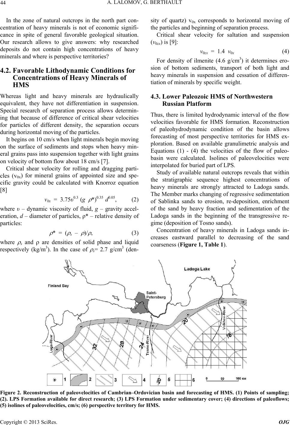
Reconstruction of hydro- and lithodynamic conditions
of the paleobasin reveals, that the velocities suitable for
HMS formation (10 - 18 cm/s) prevail only in the
south-east part of LPS location under sedimentary cover
of platform deposits (Figure 2). Detail researched terri-
tory along “glint” is not perspective for heavy minerals
concentration, because bottom velocities there exceeded
favorable limits: placer-forming heavy minerals were
carried away from this zone and deposited in the south-
east part of the basin where the velocities decreased be-
neath critical shear velocity for (at least) suspension.
Availability of this area for HMS was confirmed by
research of core samples of separate drilling holes that
reveals heavy mineral concentration of economic impor-
tance in the south-east slope of Baltic Shield [10].
5. Conclusions
Using of equations obtained in engineering geology and
hydrodynamics allows determination of sedimentary
conditions of paleobasins based on granulometric analy-
sis and textural features of the deposits. It is of signifi-
cant importance both for study of fundamental regulari-
ties of historical geology and research of mineral depos-
its of sedimentary paleobasins.
Reconstruction of paleolithodynamics of Early Paleo-
zoic terrigeneous basin of northwestern Russian platform
allows conclusion that present-day observed strata as-
signed to Middle-Late Cambrian – Early Ordovician
were deposited during short sedimentation episode that
accounts 0.05% of stratigraphic interval.
Geological conditions of studied paleobasin were fa-
vorable for formation of heavy mineral placer deposits,
but they are not revealed yet. Study of hydrodynamic
conditions favorable for heavy minerals concentration
and reconstruction of paleohydraulic environment allow
forecasting HMS deposits of economic importance in the
southeastern part on the basic under sedimentary cover of
Russian platform.
REFERENCES
[1] A. N. Geisler, “New Data on the Lower Paleozoic Strati-
graphy and Tectonics in the Northwestern Russian Plat-
form,” Materials on the Geology of the European Part of
the USSR, Gosgeoltekhizdat, Moscow, 1956, pp.
174-184.
[2] H. A. Einstein, “The Bed Load Function for Sediment
Transport in Open Channel Flow,” Tech. Bull. No 1026,
Washington, DC: U.S. Department of Agriculture, The
Soil Conservation Service, 1950, pp.1-78.
[3] P. Y. Julien, “Erosion and Sedimentation,” Cambridge
University Press, Cambridge, 1995.
doi:10.1017/CBO9781139174107
[4] G. Berthault, A. V. Lalomov and M. A. Tugarova. “Re-
construction of Paleolithodynamic Formation Conditions
of Cambrian–Ordovician Sandstones in the Northwestern
Russian Platform,” Lithology and Mineral Resources, Vol.
46, No. 1, 2011, pp. 60-70.
doi:10.1134/S0024490211010020
[5] L. L. Kulyamin and L. S. Smirnov, “Intertidal Cycles of
Sedimentation in Cambrian–Ordovician Sands of the Bal-
tic Region,” Dokl. Akad. Nauk SSSR, Ser. Geol., Vol. 212,
No. 1-3, 1973, pp. 696-699.
[6] M. A. Tugarova, M. V. Platonov and E. I. Sergeeva,
“Lithodynamic Characteristics of Terrigenous Sedimenta-
tion of the Cambrian–Lower Ordovician Sequence in the
Leningrad District,” in Historical Geology and Evolu-
tionary Geography, NOU Amadeus, St. Petersburg, 2001,
pp. 81-91.
[7] A. V. Lalomov and S. E. Tabolich, “Mechanism of For-
mation of Heavy Mineral Concentrations of Coastal
Placer Deposits of Shallow-Water Zone,” Scientific Pro-
ceedings of Kazan State University, Vol. 153, 2011, pp.
232-242.
[8] V. S. Knorroz, “Critical Shear Velocity for Non-Cohesive
Soils and Factors of Its Control,” Proceedings of VNIIG,
Vol. 58, 1958, pp. 62-81.
[9] K. I. Rossinsky and V. K. Debol’sky, “River Drifts,”
Nauka, Moscow, 1980, (in Russian).
[10] S. I. Gurvich, “Regularities in the Distribution of Rare
Metal and Stanniferous Placers,” Nedra: Moscow, Nedra,
1978, (in Russian).
Copyright © 2013 SciRes. OJG