K. A. Al q a d i ET AL.
Copyright © 2013 SciRes. CWEEE
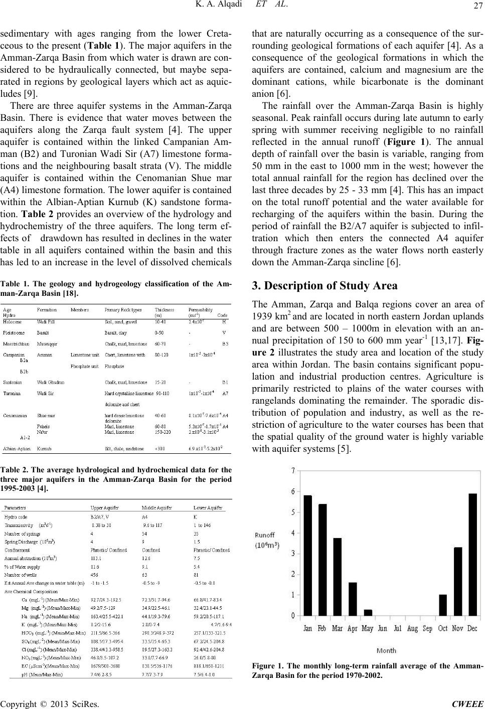
6. Discussion
This study confirmed waste effluent can have a signifi-
cant negative impact on the water quality of the aquifers
in the basin. Ho wever, thi s study indicates that the prob-
lem may come from urban areas with low sanitation in-
frastructure. Also, areas under irrigation can have a
marked, localised and temporary effect on water quality.
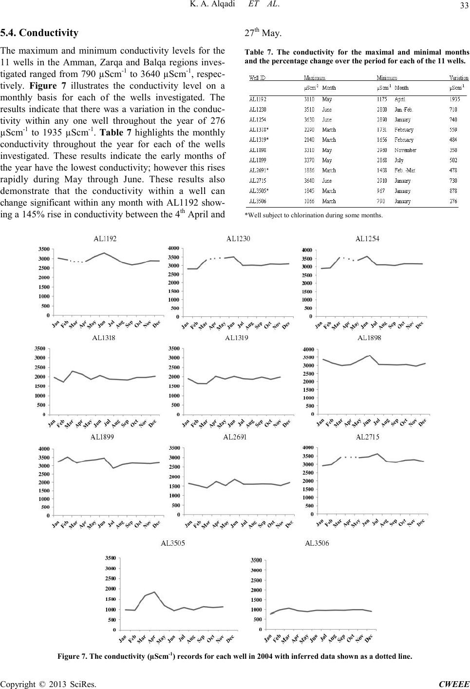
Infil tra tion i s ar eas o f u nder deve lop me nt have sig ni fica nt
increase in the conductivity, particularly as the first flush
from the rains moves through the profile. Notwithstanding
all aquifers were determined to comply with the guide-
lines for maximum permissible standards for drinking
water, except for the A2/B7 aquifer from which water is
dra wn has regions of conductivity which is outside these
standards. It must be noted that the maximum permissi-
ble level for most water contaminants in Jordan often
exceed the WHO recommendations [4].
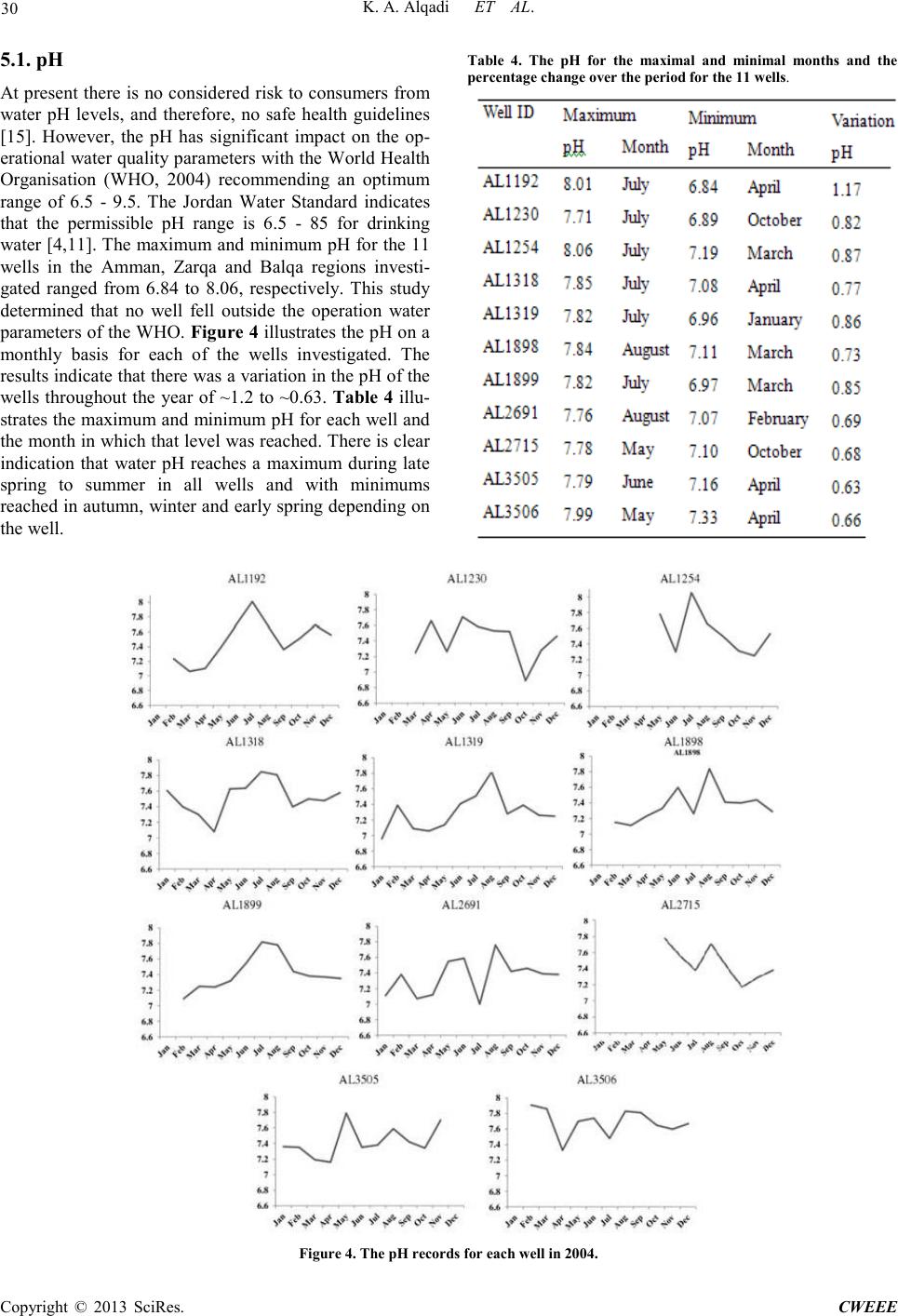
During this study the pH of all wells remained within
the permissible standards of the Jordanian water authori-
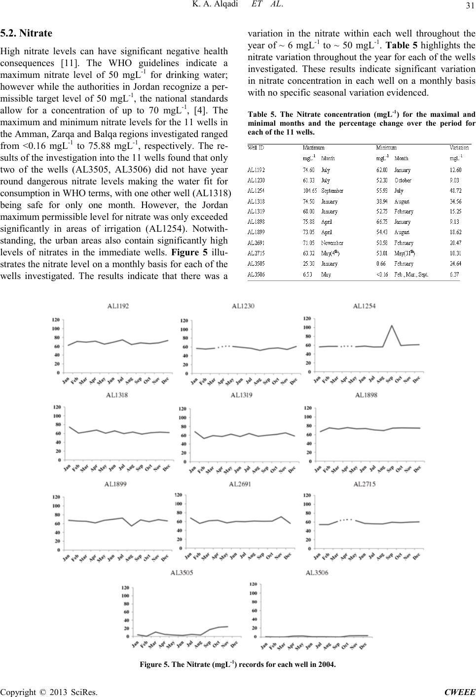
ty [4]. This study concluded that irrigation can have a
significant impact on the nitrate level of the aquifer with
nitrate levels shown to significantly exceed the maximal
permissible levels [4]. Areas of high urban density also
had higher nitrate levels which seasonally peaked at or
just above the Jordan Governmental standards for the
maximum permissible level, while lands which are
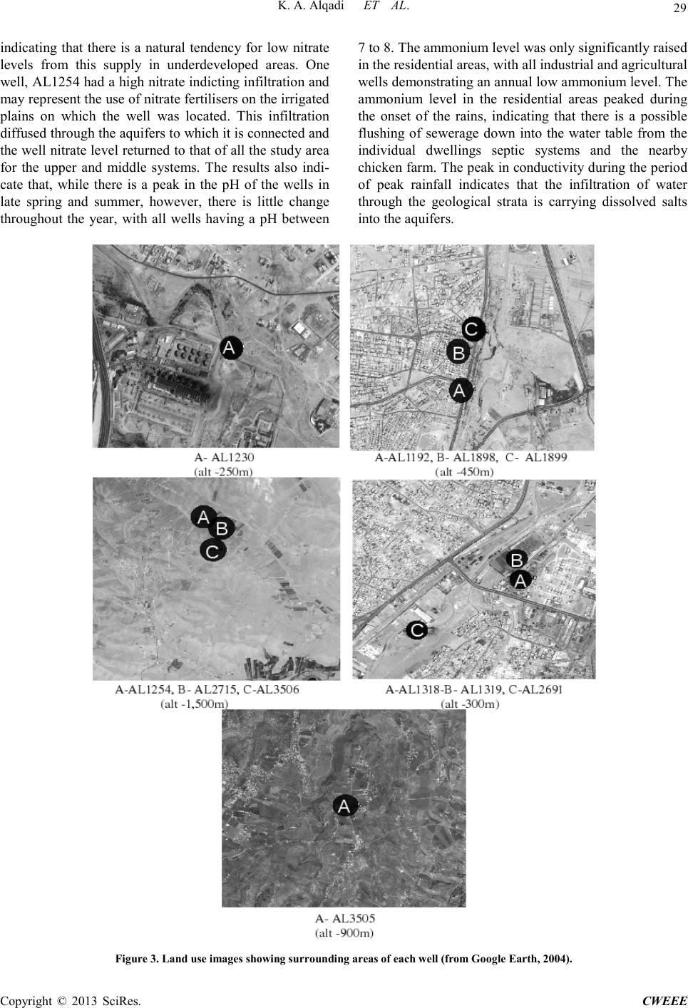
grazed have the lo west nitrates [4]. The high ammoniu m
content of AL1192, AL1898, and AL1899 is postulated
to come fro m infiltration o f the efflue nt from the c hicken
farm, indicating that ammonium contamination is highly
dependent on land use. The conductivity was found to be
lo wes t in the ra ngela nds wit h irri gated, urban, and ind us-
tria l lands s howi ng the highe st re adings. T his re flect s the
level of water use in each of these areas, indicating that
drawdown has a negative impact on the conductivity of
the water. This study confirms the results obtained in
neighboring aquifer systems in Jordan that indicate that
urbanizatio n and industrializat ion, coup led with intensive
agriculture, have a negative impact on water quality
when compared to natural rangeland systems [2,10].
Many of the aquifer systems in Jordan are under threat
from overexploitation and this unsustainable drawdown
will lead to many systems becoming dry by 2030 to 2040
[8].There is a need for increased monitoring throughout
the Amman, Zarqa and Balqa regions over a long term in
order to capture a more reliable image of the declines in
water quality and regulate the water extraction or face the
loss of the aquifer system [4,13,18].
7. Conclusions
The aquifers within the Amman, Zarqa and Balqa regions
are affected by irrigation, industrialisation and urbansia-
tion. The increased drawdown of the aquifers has led to
declines in the water quality o ve r t he lo ng ter m. T he mon-
thly variations in water quality parameters are signifcantly
affected by the rainfall which leads to infiltration of
water that carries pollutants from anthropogenic sources
and dissolved salts from the geological strata that the
water moves through. The drawdown of the aqufers has
led to a concentration of salts and other contaminants that
would have previously been dispersed in a historical
larger water volume.
REFERENCES
[1] M. Al-Farajat, I. Hamdan, K. Jaber, and S. H. Mo-
hammed, “GIS Mapping of Ground Water Vulnerability
against Pollution in Amman Using DRASTIC
dex, ”Hydrogeologie und Umwelt, Vol. 33, No. 9, 2005,
pp. 1-19.
[2] A. Al-Hanbali and A. Kondoh, “Ground Water Vulnera-
bility Assessment and Evaluation of Human Activity Im-
pact (HAI) within the Dead Sea Groundwater Basin, Jor-
dan,” Hydrogeology Journal, Vol. 16, 2008, pp.
499-510. doi:10.1007/s10040-008-0280-7
[3] E. K. Al-Karablieh, A. S. Jabarin and M. A. Tabieh,
“Jordan Horticultural Export Competit iveness fro m Water
Perspective,” Journal of Agricultural Science and Tech-
nology, Vol. B1, 2011, pp. 964-974.
[4] J. Al-Mahamid, “Integration of Water Resources of the
Upper Aquifer in Amman-Zarqa Basin Based on Mathe-
matical Modeling and GIS, Jordan,” Freiberg Online Ge-
ology, Vol. 12, 2005, pp. 7-223.
[5] Al-Mashagbah, R. Al-Adamat, and E. Salmeh, “The Use
of Kri gin g Techniques with in GIS Environment to Inves-
tigate Groundwater Quality in the Amman-Zarqa Ba-
sin/Jordan,” Research Journal of Environmental and
Earth Sciences, Vol. 4, No 2, 201 1, pp. 177-185.
[6] E. Al-Tarazi, J. A. Rajab, A. Al-Naqa and M . El-Waheidi,
“Detecting Leachate Plumes and Groundwater Pollution
at Ruseifa Municipal Landfill Utalising VLF-EM Me-
thod,” Journal of Applied Geophysics, Vol. 65, 2008, pp.
121-131. doi:10.1016/j.jappgeo.2008.06.005
[7] P. Balakrishnan, A. Saleem and N. D, “Mallikarjan,
Groundwater Quality Mapping Using Geographic Infor-
mation System (GIS): A Case Study of Gulbarga City,
Karnataka, India,” African Journal of Environmental
Science and Technology, Vol.5, No. 12, 2011, pp.
1069-1084. doi:10.5897/AJEST11.134
[8] J. Dottridge and N. A. Jaber, “Groundwater Resources
and Quality in Northeastern Jordan: Safe Yield and Sus-
tainability,” Applied Geography, Vo l. 19, pp.
313-323. doi:10.1016/S0143-6228(99)00012-0
[9] A. El-Naqa, N. Hammouri and M. Kuisi, “GIS- Based
Evaluation of Groundwater Vulnerability in the Russeifa
Area Jordan,” Revista Mexicana de Ciencias Geológicas,
Vol. 23, 1999, pp. 277-287.
[10] N. Hammouri and A. El-Naqa, “GIS Based HydroGeo-
logical Vulnerability Mapping of Ground Water Re-
sources in Jerash Area- Jordan,” Geofísica Internacional,