Open Journal of Geology
Vol.3 No.4(2013), Article ID:35138,7 pages DOI:10.4236/ojg.2013.34033
Paleo-Structuring Ante-Albian on the South-Tethysian Margin (Example: The Central Tunisian Atlas)
1Faculté des Sciences de Gafsa, Sidi Ahmed Zarroug, Gafsa, Tunisia
2Faculté des Sciences de Bizerte, Jarzouna, Bizerte, Tunisia
Email: *chekhmahoucine@yahoo.fr
Copyright © 2013 Houcine Chekhma, Noureddine Ben Ayed. This is an open access article distributed under the Creative Commons Attribution License, which permits unrestricted use, distribution, and reproduction in any medium, provided the original work is properly cited.
Received March 28, 2013; revised April 29, 2013; accepted May 11, 2013
Keywords: Strike Slip Fault; Zonation; Paleo-Structuring; Tunisian Atlas; Lower Cretaceous
ABSTRACT
The study of the tectono-sedimentary evolution of the lower Cretaceous series realized in the southern on the tethysian margin in the Tunisian central-Southerner Atlas, shows that the architecture of this field is governed by a NW-SE compressive phase. This latter has reactivated the old faults to give birth to associated, distensive and compressive structures at the same time simultaneously. It is about a network of combined strike slip fault EW dextral and sinistral NS which divided the cover into four zones of deformation corresponding to the right dihedron of the strike slip fault system. In the compressive dihedron, the deformation develops essentially several folds and in the distensive dihedron, normal faults which delimit horsts and grabens.
1. Introduction
In Tunisia, the tectonic demonstrations of the lower Cretaceous are many and varied. The dispersion and the diversity of these indices tectonics and their contemporanety with the Triassic movements led to various interpretations (compressive, distensive and/or strike slip fault movement), although this tectonics is largely studied but no synthesis was proposed.
In the Tethys field, the lower Cretaceous is marked by the opening of the South Atlantic and the first tectonic pulsation. In this period, Tunisia which is located on the southern tethysian margin, is found under the influence of this tectonic activity: the sedimentary deposits of this time record various tectonic sedimentary phenomena: in the northern Tunisian Atlas, Triassic borings date from Aptian-upper Albian [1-3]. In central Tunisia, the lower Cretaceous is marked by the reactivation of the old accidents NS, EW and NW-SE which affect this atlasic platform [4-9].
In the NS axis field, the lower Cretaceous series fossilize synsedimentary tectonic structures (faults, folds and discordance) testifying to a compression NW-SE of upper Aptian than upper Aptian-upper Albian age [6,10]. In the Bir El Hafey area a compressive palaeo-constraint is highlighted in the lower Cretaceous series [11]. The seismic profile interpretation of Kasserine area highlights a NE-SW distension during the lower Cretaceous [12-14]. This extension is also signaled in the Kef area [15]. In the Tunisian South, some folds along EW Tebaga accident evoke strike slip fault movement of Aptian tectonics age [13] and in the Salt area the sedimentary sequence record this Austrian phase [16]. In the Saharian Atlas, [9] announces a condensation of the Barremian-Aptian series and NE-SW an extension at that time.
Sidi Aich-Bir El Hafey-Majoura-Meloussi area (Figure 1) located on the Tunisian central Atlas. It is consisted by the fitting of Atlasic folds (NE-SW direction). These solid masses are in the lower Cretaceous heart, surmounted in discordance by the upper Albian series. Miocene and quaternary compressive tectonics affected a sedimentary cover and compartmentalized this field in tabular zones occupied by the Gafsa vast plain in the southwest and Sidi Bouzid plain in northeast and in zones occupied by folded structures in the Northwest and the Southeast. Jebel Meloussi belongs to this sector, but is moulded on a great fault, that has an exceptional almost east-west direction.
The tectonic analysis shows that this area is affected by the NS fault of Ben Aoun (FBA) and the EW accident
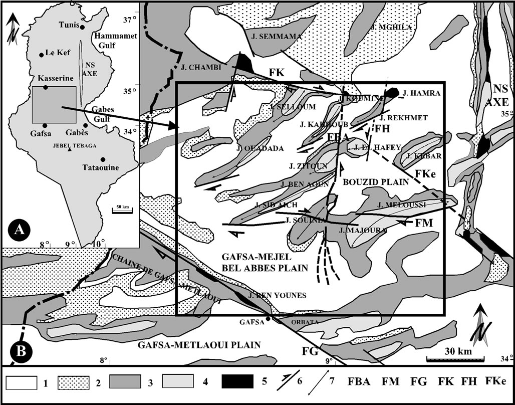
Figure 1. A, Studied sector. B, Studied structures: 1, Quaternary; 2, Neogene; 3, Upper Cretaceous; 4, Lower Cretaceous; 5, Trias; 6, Strike slip fault; 7, Anticlinal axis; FAB, North-south Sidi Ali Ben Aoun fault; FM, East-west Meloussi fault; FG, Northwest-southeast Gafsa fault; FK, East-west Kasserine fault; FH, North-south El Hafey fault; FKe, Northwest-southeast Kebar fault.
of Meloussi (FM) which have controlled the variations of facies and thicknesses of the cretaceous series [4,5]. The detailed study of the tectonic deformation in the lower Cretaceous series around these great accidents reveals that the configuration of this field is formed by the alternation of compressive and distensive zones.
2. The Lower Cretaceous of Central Tunisia
The Lower Cretaceous (Figure 2) was initially subdivided in lithological units [4]; recently, precise age details were brought [5,17-19]. The series leveling in the zone cover the Hauterivian-Cenomanian period with a hiatus of the lower and middle Albian which is materialized by a unconformity covering all central Tunisia [20]. In this field, the upper Albian series are unmatched on various terms of the Barremian-aptian series.
The Hauterivian is represented by the Boudinar Formation. It is primarily a sandy unit (ends, means and especially coarse) containing rare silty last on in its higher part.
The Upper Hauterivian-Barremian includes the lithological units of Bouhedma and Sidi Aïch:
• the Bouhedma formation is made up of fine limestones, locally oolite and bioclasts, of rolled dolomites, gypsum, sometimes variegated clays and fine sands;
• the Sidi Aïch formation is generally a sand entity, fine to very fine, white or grey beige. This entity contains at its base clays, silty clays and carbonated benches. The Upper Barremian-Aptian covers all the Orbata formation. This one is subdivided into two members or lower Orbata and higher Orbata [21-25]:
• the lower limb of Orbata (Upper Barremian-Bedoulian) is represented by an argillocarbonate bar [5,21];
• the upper limb of Orbata (Gargasian-Clansayesian) rests in discordance on the lower Orbata. It is formed by marl alternations, limestones, sands, and dolomites.
The zebbeg formation is also formed by two members:
• The Upper Albian is represented by the lower limb of the zebbeg formation. This one rests in discordance on one or the two members of the Orbata formation. It is made up of clays, marls, carbonates, and lumachelle intercalations.
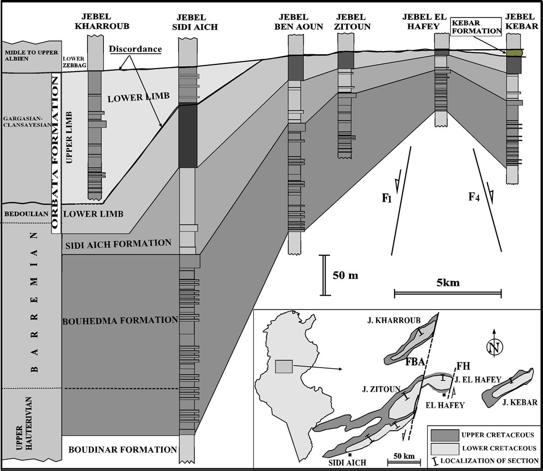
Figure 2. Correlation between the Cretaceous lithological units of the studied area.
• The Cenomanian series is represented by the upper limb of the zebbeg formation. It is composed of clays and fossiliferous limestones and lumachelles in its lower part and marls and dolomites in its upper part.
3. The Ante-Albian Deformation and Structures Associated
During Hauterivian-Aptian, tectonics has remobilized the old accidents of the area in strike slip fault NS sinistral and EW dextral which have generated varied placated structures (Figure 3). These great fractures subdivide the area in four opposite zones with two to two compressive and distensive deformations.
3.1. Compressive Structure
The compressive structures (folds and reverse faults) located on the NW and SE zones of Jebel Souinia (Figure 4).
In these sectors, the deformation appears essentially by pluridecametric to kilometric NE-SW synsedimentary folds without periclinal closing on the side of the accident (FBA and FM) and which are recovered by levels of the same age or overcome in angular unconformity by lower Orbata (upper Barremian-Bedoulian). These folds develop in the alternations of the Bouhedma formation (Hauterivian-Barremian) which occupy the heart of Jebels Zitoun, Ben Aoun and Sidi Aich (zone NW) (Figures 4(B) and (C)), those of Majoura and Meloussi Jebels (zone SE) (Figure 4(d)).
These compressive structures also appear in Jebel Kharroub. On the level of this mountain the upper Albian covers in discordance Gargasian-Clansayesian (upper limb of Orbata). Alternations of this member occupy the heart of this Jebel and they fossilize several synsedimentary directed to NE-SW folds (Figure 4(A)). The stereographic representations show that along the NS fault (FBA) the axes of the synsedimentary folds are directed N30 to N46 and plunge from 20˚ to 30˚ towards the NE or SW and along EW accident (FM) are directed N60 to N70 with a dip from 10 to 30 to the WSW or the ENE (Figure 4(D)). The directions of the axes express a
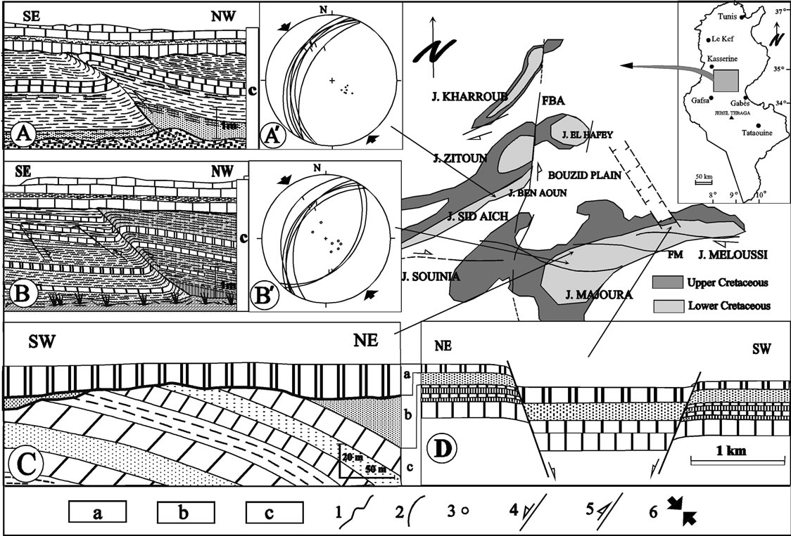
Figure 3. Tectonic events during lower Cretaceous in the central Tunisian Atlas. A, Lower Orbata; B, Sidi Aich formation; C, Bouhedma formation; 1, Discordance; 2, Fault plane; 3, Pole of fault; 4, Normal Fault; 5, Riverse Fault; 6, direction of compression. A and B, Synsedimentary reverse fault in alternations of Bouhedma; A’ and B’, Stereographic projection of synsedimentary reverse faults (Schmidt pattern; lower hemisphere); C, Discordance of lower Orbata on the sands of Aich and different levels of Bouhedma; D, Synsedimentary fault affecting the Barremian-Bedoulian.
shortening NW-SE and a dextral and sinistral torsion respectively along two accidents FM and FAB.
These two compressive zones also fossilize in the Bouhedma formation, synsedimentary gaps, discordance (Figure 3(C)) and metric to decametric synsedimentary faults. They are reverse faults (Figures 4(A) and (B)) of 0.5 - 1 m of rejection towards the Northerner are of N20 direction in N35 and dip of 30˚ to 45˚ towards the northwest (after swinging). The stereographic projection (lower hemisphere) of these reverse faults allows us to derive the shortening axis is oriented NW-SE (Figures 3(A) and (B)).
3.2. Distensive Structures
The distensive structures occupy the Sidi Bouzid and Gafsa-Mejel Bel Abbes plains which constitute subtabular zones.
• In the Sidi Bouzid plain (Figure 4), exposed cretaceous grounds covered by quaternary encrusting level. These grounds are affected by great NW-SE accidents being delimiting grabens and horsts relatively low [5,25]. They are great synsedimentary faults visible in the Barremian-Aptian sub-tabular series of the northern anticlinal limb of Jebel Meloussi. They are normal faults of N130 direction to N170 showing mirrors dipped 60˚ to 80˚ towards the East or the West and carrying scratches with strong vertical components (40˚ to 80˚ towards the North-East or South-West). The stereographic projection (lower hemisphere) of these normal faults allow us to deduce that the extension axis is oriented NE-SW (Figures 4(E) and (F)). These normal faults limit one graben. On both sides of these accidents the Barremian-Aptian series show many variations of facies and thickness (Figure 3(D)). This tectonic activity appears at the end of Bedoulian by the collapse of the continental field of J. Kebar (Figures 1 and 4). It is about a sedimentary basin, limited to South-west by a normal fault of N140 direction which plunges towards the NE and towards the East (FKe). This basin is limited by the NS axis which has functioned in high bottom since the Jurassic period [11]. The continental formation of the J. Kebar (side equivalent of upper limb of Orbata) is overcome in discordance by the upper Albian (Figure 2).

Figure 4. Zonation of compressive structures and distensive structures. 1, Quaternary; 2, Neogene; 3, upper Cretaceous; 4, Lower Cretaceous; 5, Anticlinal axis; 6, Synclinal axis; 7, Normal Fault; 8, Reverse Fault; 9, Strike slip fault; 10, Overlapping; 11, Direction of compression; 12, Direction of the extension; 13, Pole of the axis of synsedimentary fold; 14, Fault plane; FBA, Ben Aoun fault; FM, Meloussi Fault; FH, El Hafey fault; FKe, Kebar fault. A, B, C and D, Stereographic projection of the poles of the axes of the synsedimentary folds; E and F, Stereographic projection of the synsedimentary faults in the lower Cretaceous; G, Diagram of the dihedron of deformation.
• The SW zone of Jebel Souinia is marked by the Gafsa NW-SE fault. This accident limits two large plains filled by approximately 400 m of plio-quaternary deposits: in the NE that of Gafsa-Mejel Abbes and with the SW that of Gafsa-Metlaoui.
During the lower Cretaceous the NW-SE Gafsa accident is reactivated in normal fault [8,12,26] which broke down the NE compartment occupied by approximately 1800 with 2400 m of sediments, whereas on the level of compartment SW of the fault (the area of Gafsa-Metlaoui) the lower Cretaceous is of approximately 1200 m thickness [27]. The data of geophysics show that the underlying structure of the plain of Gafsa-Mejel Bel Abbes is affected by directed accidents N120 to N140 whose rejections are estimated to about 500 m. These faults delimit two NW-SE ditches separated by the horst from El Magtaa. The cartography of this area [28] and the subsurface data show that the deposits are thick in the center of the plain [29].
Thus, the sectors and SW of Sidi Bouzid and GafsaMejel Bel Abbes correspond to a saturation zone in horsts and grabens oriented NW-SE which are located in the two dihedron in extension of combined strike slip faults EW dextral and NS sinistral of Ben Aoun and Meloussi (FBA and FM). In these dihedron, the NE-SW component of lengthening compensates the shortening produced by the compressive structures (Figure 4).
4. Interpretation and Conclusions
In the central Tunisian Atlas, compressive tectonics of the lower Cretaceous have divided Sidi Aich-Bir El Hafey-Majoura-Meloussi platform into several basins separated by major accidents that have guided variations of facies and thicknesses. The accidents close to NS and EW are respectively reactivated dextral and sinister strike slip faults. These orthogonal accidents have played the role of mechanical anisotropies. They defined four zones of deformation which correspond to the four dihedrons of the combined sheerings system (Figure 4). In compressive dihedron, develop folds and reverse faults oriented perpendicularly to the direction of compression, discordance and sedimentary gaps, whereas the extension dihedron arise horsts and grabens oriented parallel to the direction of the shorting stress.
In Tunisia, several sedimentary-tectonic structures are contemporary and compatible with this compressive phase of the lower Cretaceous: in the area of Kef, along the synsedimentary faults of NS and EW direction, the series of Valanginian-Barremian show discordances, gaps, variations thicknesses and facies and the reduced lower Albian, rests directly on Barremian [15]. In the Hammamet Gulf, the sub-meridian accidents show a reverse strike slip fault movement at that time [13]. In central Tunisia, and on the Saharan platform, this tectonic phase generated horsts and grabens of NW-NE direction [30,31]. In the Gabes Gulf, tankers highlighted NE-SW reverse faults contemporary of Aptian sedimentation [13].
This tectonic reported throughout Tunisia (on the ground and at the sea), has explained the high zones which are the seat of facies and thickness variations, of sedimentary gaps and/or angular unconformities and the low zones where the sedimentary sequences are thicker and complete. This compressive mode, also mentioned in Algeria [32], is underlined by a NW-SE directed compression, which persisted in the Aptian [10].
The direction of shortening generated by this compressive phase, in other words the direction of the principal constraint corresponds well to that produced by the sinistral displacement of Africa compared to Europe during lower Cretaceous [33].
The superposition of at least two axes at the level of the structures shows that the zones where these Cretaceous folds are outlined remained always favorable to later crumpling (crumpling Atlasic) and that the disturbances in the directions of the faults and the axes of the syn-Cretaceous folds are due to reorientations induced by Atlasic and quaternary tectonics and the remobilization of the old faults in strike slip faults (dextral and sinistral).
REFERENCES
- E. Laatar, “Gisement de Plomb-Zinc et Diapirisme du Trias Salifère en Tunisie Septentrionale. Les Concentrations Peridiapiriques du District Minier de Neffat-Fej Lahdoum (Region de Teboursouk),” Thèse, Université Paris, Paris, 1980, 280 p.
- V. Perthuisot, “Dynamique et Pétrogenèse des Extrusions Triasiques en Tunisie Septentrionale,” Presse de l’Ecole Normale Supérieure, Travaux du Laboratoire de Géologie, Paris, No. 12, 1978, 312 p.
- H. Rouvier, “Géologie de l’Extrême Nord Tunisien: Tectoniques et Paléogéographies Superposées à l’Extrémité Orientale de la Chaine Nord Maghrébine,” Thèse Doctorat es Sciences, Pierre and Marie Curie University, Paris, 1977.
- P. F. Burollet, “Contribution à l’Etude Stratigraphique de la Tunisie Centrale,” Annales des Mines et de la Géologie Tunisie, Vol. 18, 1956, 350 p.
- H. Chekhma, “Etude Stratigraphique, Sédimentologique et Tectonique de la Région de Bir El Hafey—Sidi Ali Ben Aoun (Tunisie Centrale),” Ph.D. Thèse, Université Tunis II, Tunis, 1996, 261 p.
- M. Rabhi and N. Ben Ayed, “Mise en Evidence d’Une Tectonique Compressive D’age Aptien Supérieur en Tunisie Centrale,” Notes Service Géologique. Tunis, No. 56, 1990, pp. 89-98.
- A. Rigane and C. Gourmelen, “Inverted Intracontinental Basin and Vertical Tectonics: The Saharan Atlas in Tunisia,” Journal of African Earth Sciences, Vol. 61, No. 2, 2011, pp. 109-128. doi:10.1016/j.jafrearsci.2011.05.003
- F. Zargouni, “Tectonique de l’Atlas Méridional de Tunisie. Evolution Géométrique et Cinématique des Structures en Zones de Cisaillement,” Doctorat d’Etat, Université Louis Pasteur, Strasbourg, 1985, 296 p.
- T. Zouaghi, I. Ferhi, M. Bédir, M. Ben Youssef, M. Gasmi and M. H. Inoubli, “Analysis of Cretaceous (Aptian) Strata in Central Tunisia, Using 2D Seismic Data and Well Logs,” Journal of African Earth Sciences, Vol. 61, No. 1, 2011, pp. 38-61. doi:10.1016/j.jafrearsci.2011.05.002
- M. Rabhi, H. Chekhma and F. Zargouni, “Cadre Géodynamique de la Sédimentation Albo-Aptienne Dans l’Atlas Tunisien,” In: A. Arnaud-Vanneau, N. Arndt and I. Zghal, Eds., Global Events during the Quiet Aptian-Turonian Superchron, Grenoble, 2005, pp. 21-23.
- H. Chekhma and M. Rabhi, “Compressive Palaeostress in the Mesozoic Cover of the Tunisian Atlas in Relation with Africa-Europe Moving Together,” Comptes Rendus Geoscience, Vol. 340, No. 6, 2008, pp. 414-419. doi:10.1016/j.crte.2008.04.003
- S. Aymen, D. Chardon, P. Baby and J. Ouali, “Active oblique ramp faulting in the Southern Tunisian Atlas,” Tectonophysics, Vol. 499, No. 1-4, 2011, pp. 178-189. doi:10.1016/j.tecto.2011.01.010
- N. Ben Ayed, “Evolution Tectonique de l’Avant-Pays de la Chaîne Alpine de Tunisie du Début du Mésozoïque à l’Actuel,” Annales des Mines et de la Géologie, Vol. 32, 1986, 296 p.
- L. Chihi, “Les Fossés Neogènes à Quaternaires de la Tunisie et de la Mer Pélagienne: Leur Signification dans le Cadre Géodynamique de la Méditerranée Centrale,” Doctorat d’Etat, Université de Tunis II, Tunis, 1995, 324 p.
- M. Chikhaoui, A. L. Maamouri, J. Salaj, M. M. Turki, J. Saadi, M. Ben Youssef, M. Ghanmi and M. Zarbouta, “Blocs Basculés au Crétacé Inferieur Dans la Région du Kef (Tunisie Nord-Occidentale),” Paris, Sciences de la terre et des Planètes/Earth & Planetry Sciences, Vol. 327, No. 2a, 1998, pp. 265-270.
- L. Marzouk, T. Zouaghi and M. Ben Youssef, “Austrian Phase on the Northern African Margin Inferred from Sequence Stratigraphy and Sedimentary Records in Southern Tunisia (Chotts and Djeffara Areas),” Comptes Rendus Geoscience, Vol. 340, No. 8, 2008, pp. 543-552. doi:10.1016/j.crte.2008.05.005
- M. Ben Youssef, “Stratigraphie Génétique du Crétacé de Tunisie: Micropaléontologie, Stratigraphie Séquentielle et Géodynamique des Bassins de la Marge Sud et Péri-Té- thysienne,” Thèse, Doctorat d’Etat, Université Tunis II, Tunis, 1999, 402 p.
- R. Damotte, I. Zghal and H. Bismuth, “Les Marnes de l’Hautérivien-Barrémien du Jebel M’rhila (Tunisie Centrale): Analyse Biostratigraphique et Contexte Paléogéographique,” Cahier Micropaleontologique, No. 2, 1987, pp. 5-24.
- L. Memmi, “Le Crétacé Inférieur (Berriasien-Aptien) de Tunisie. Biostratigraphie, Paléogéographie et Paléoenvironnements,” Thèse d’État, Université Claude-Bernard, Lyon, 1989, 158 p.
- H. Bismuth, C. Boltenhagen, P. Donze, J. Lefèvre and P. Saint Marc, “Le Crétacé Moyen et Supérieur du Jebel Semmama (Tunisie du Centre-Nord), Evolution Sédimentologique et Microstratigraphique,” Cretaceous Research, Vol. 3, No. 1-2, 1981, pp. 171-186. doi:10.1016/0195-6671(82)90018-0
- F. Chaabani and S. Razgallah, “Aptian Sedimentation of Interaction between Tectonics and Eustatics in Central Tunisia,” Geological Society, Vol. 262, 2006, pp. 55-74. doi:10.1144/GSL.SP.2006.262.01.03
- H. Chekhma, P. Donze, S. Razgallah and M. Lucia, “Le Crétacé Inférieur de la Région de Bir El Hafey, Précisions Chronostratigraphiques sur les Formations Bouhedma,” Notes Service Géologique. Tunis, No. 8, 1990, pp. 51-56.
- J. Lehmann, M. Heldt, M. Bachmann and M. E. H. Negra, “Aptian (Lower Cretaceous) Biostratigraphy and Cephalopods from North Central Tunisia,” Cretaceous Research, Vol. 30, No. 4, 2009, pp. 895-910. doi:10.1016/j.cretres.2009.02.002
- J. P. Masse, “Données Nouvelles sur la Stratigraphie de l’Aptien Carbonaté de Tunisie Centrale, Conséquences Paléogéographiques,” Bulletin de la Société Géologique de France, No. 6, 1984, pp. 1077-1086.
- N. Ben Ayed, H. Chekhma and M. Gueddiche, “La Zonation des Structures Compressives et Distensives de la Tunisie Centrale et ses Relations avec les Décrochements,” Comptes Rendus de l’Académie des Sciences. Paris, Vol. 324, No. 2a, 1997, pp. 485-490.
- D. F. de Lamotte, “Mesozoic and Cenozoic Vertical Movements in the Atlas System (Algeria, Morocco, Tunisia): An Review,” Tectonophysics, Vol. 475, No. 1, 2008, pp. 9-28. doi:10.1016/j.tecto.2008.10.024
- A. Hlaiem, “Halokinesis and Structural Evolution of the Major Features in Eastern and Southern Tunisian Atlas,” Tectonophysics, Vol. 306, No. 1, 1999, pp. 79-95. doi:10.1016/S0040-1951(99)00045-1
- A. O. Grib and F. Sliman, “Carte Géologique de Sidi Aich 1/100000, Feuille N°60, Carte Levée Dans le Cadre du Projet de Cartographie de la Compagnie des Phosphates de Gafsa,” Publiée par le Service Géologique de Tunisie, 1993.
- T. Zouaghi, M. Bédir and M. H. Inoubli, “Structuration Profonde des Dépôts de l’Albien-Maastrichtien en Tunisie Centrale: Nouvelle Limite de l’Archipel de Kasserine et Implications Géodynamiques,” Comptes Rendus Géoscience, Vol. 337, No. 7, 2005, pp. 685-693. doi:10.1016/j.crte.2005.02.006
- N. Ben Ayed and M. Khéssibi, “Sur l’Evolution Gédynamique de la Djeffara Tunisienne au Cours du Mésozoique,” Notes Service Géologique. Tunis, No. 47, Travaux de Géologie Tunisie, No. 15, 1983, pp. 41-53.
- I. Viterbo, “Evoluzione Paleogeografica della Tunisia meridionale dal Carbonifero al Trias Superior. Studi Paleogeografici Nell’ Area Mediterranea,” Adriatica Editrice, Bari, 1983, 23 p.
- A. Boudjemaa, “Évolution Structurale du Bassin Pétrolier Triasique du Sahara Nord-Oriental (Algérie),” Thèse, Université Paris-11, Orsay, 1987, 173 p.
- J. Dercourt, L. P. Zonenshain, L. E. Ricou, V. G. Kazmin, X. Le Pichon, A. L. Knipper, C. Grandjacquet, I. M. Sborshchikov, J. Boulin, O. Sorokhtin, J. Geyssant, C. Lepvrier, B. Biju-Duval, J.-C. Sibuet, L. A. Savostin, M. Westphal and J. P. Lauer, “Présentation de Neuf Cartes Paléogéographiques au 1/20 000 000 s’Etendant de l’Atlantique au Pamir pour la Période du Lias à l’Actuel,” Bulletin de la Societe Geologique de France, Vol. 5, 1985, pp. 637-652.
NOTES
*Corresponding author.