Paper Menu >>
Journal Menu >>
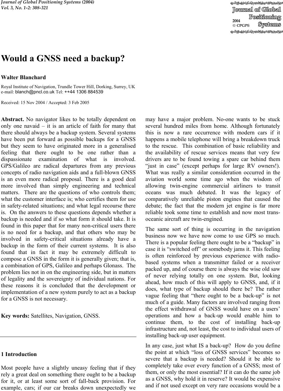 Journal of Global Positioning Systems (2004) Vol. 3, No. 1-2: 308-321 Would a GNSS need a backup? Walter Blanchard Royal Institut e of Navigation, Trundle Tower Hill, Dorking, Surrey, UK e-mail: blanch@pncl.co.uk Tel: ++44 1306 884539 Received: 15 Nov 2004 / Accepted: 3 Feb 2005 Abstract. No navigator likes to be totally dependent on only one navaid – it is an article of faith for many that there should always be a backup system. Several systems have been put forward as possible backups for a GNSS but they seem to have originated more in a generalised feeling that there ought to be one rather than a dispassionate examination of what is involved. GPS/Galileo are radical departures from any previous concepts of radio navigation aids and a full-blown GNSS is an even more radical proposal. There is a good deal more involved than simply engineering and technical matters. There are the questions of who controls them; what the customer interface is; who certifies them for use in safety-related situations; and what legal recourse there is. On the answers to these questions depends whether a backup is needed and if so what form it should take. It is found in this paper that for many non-critical users there is no need for a backup, and that others who may be involved in safety-critical situations already have a backup in the form of their current systems. It is also found that in fact it may be extremely difficult to compose a GNSS in the form it is generally given; that is, a combination of GPS, Galileo and perhaps Glonass. Th e problem lies not in on the engine ering side, but in matters of legality and the sovereignty of individual nations. For these reasons it is concluded that the development or implementation of a new system purely to act as a backup for a GNSS is not ne ce ss ary. Key words: Satellites, Navigation, GNSS. 1 Introduction Most people have a slightly uneasy feeling that if they rely a great deal on something there ought to be a backup for it, or at least some sort of fall-back provision. For example, cars; if our car breaks down unexpectedly we may have a major problem. No-one wants to be stuck several hundred miles from home. Although fortunately this is now a rare occurrence with modern cars if it happens a mobile telephone will bring a breakdown truck to the rescue. This combination of basic reliability and the availability of rescue services means that very few drivers are to be found towing a spare car behind them “just in case” (except perhaps for large RV owners!). What was really a similar consideration occurred in the aviation world some time ago when the wisdom of allowing twin-engine commercial airliners to transit oceans was much debated. It was the legacy of comparatively unreliable piston engines that caused the debate; the fact that the modern jet engine is far more reliable took some time to establish and now most trans- oceanic aircraft are twin-engined. The same sort of thing is occurring in the navigation business now we have now come to use GPS so much. There is a popular feeling there ought to be a “backup” in case it is “switched off” or somebody jams it. This feeling is often reinforced by previous experience with radio- based systems when a transmitter failed or a receiver packed up, and of course there is alw ays the wise old saw of never relying totally on one system. But, looking ahead, how much of this will apply to GNSS, and, if it does, what type of backup should there be? The rather vague feeling that “there ought to be a back-up” is not much of a guide. Many factors are invo lved ranging fro m the effect withdrawal of GNSS would have on a users’ operations and how a back-up would enable him to continue them, to the cost of installing back-up infrastructure and, not least, the cost to individual users of installing back - u p us er equipment. In any case, just what IS a back-up? How do you define the point at which “loss of GNSS services” becomes so severe that a backup is needed? Should it be able to completely take over every function of a GNSS; most of them, or only the most essential? If it can do the same job as a GNSS, why hold it in reserve? It would be expensive and if not used except on very rare occasions would be a 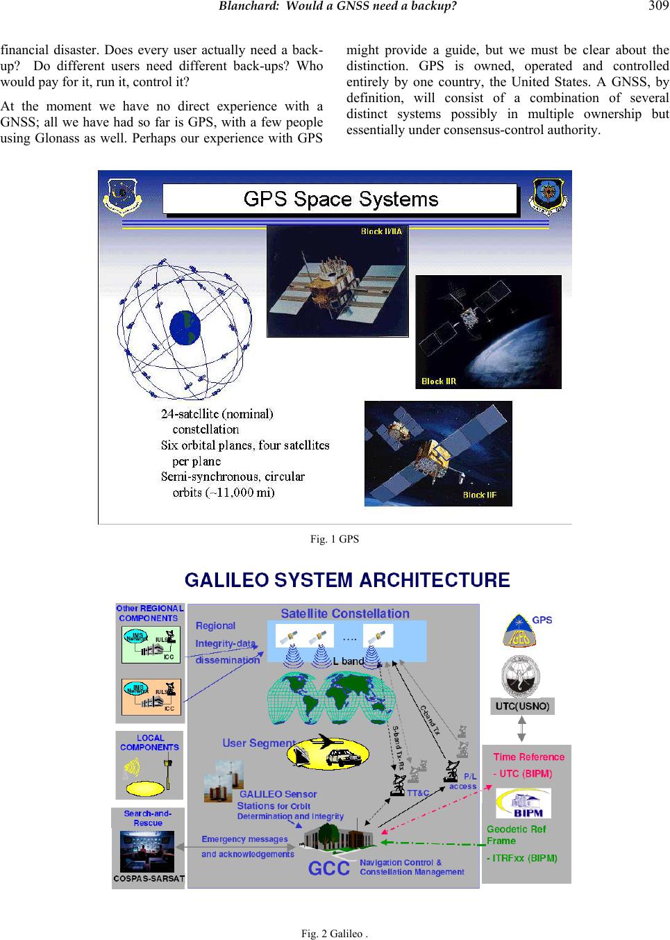 Blanchard: Would a GNSS need a backup? 309 financial disaster. Does every user actually need a back- up? Do different users need different back-ups? Who would pay for it, run it, control it? At the moment we have no direct experience with a GNSS; all we have had so far is GPS, with a few people using Glonass as well. Perhaps our experience with GPS might provide a guide, but we must be clear about the distinction. GPS is owned, operated and controlled entirely by one country, the United States. A GNSS, by definition, will consist of a combination of several distinct systems possibly in multiple ownership but essentially under consensus-control authority. Fig. 1 GPS Fig. 2 Galileo .  310 Journal of Global Positioning Systems 2. THE GPS SITUATION; NON -MANDATORY USERS. Fig. 3 GNSS Market (from a diagram by EC GJU). This diagram shows that by far the great majority of users of a GNSS will in the category of “non-mandatory” users – those who are not compelled by law to carry a satnav system. They might be termed “voluntary” users. Fig. 4 “Voluntary” user s. So let’s start by looking at how GPS is used by them. The category includes the millions of “pleasure” sailors and aviators; the even more numerous car-drivers who found a GPS in their new car; and all those others using it on what might be called a “hobby” basis. For most of them, GPS is a luxury and many do not even bother to learn how to use it properly. Its loss would be inconsequential and they would just fish out the old map every car has under the seat. Commercial vehicles use it rather more seriously to find addresses and alternative routes but here again no commercial driver is without his A-to-Z and a good map. Discretional vehicle-tracking systems (those not required by law) would undoubtedly miss it but not all use GPS. If any of these users really felt it was essential to have it at all times they would either install a system not based on GPS, or make arrangements for their own back-up. Datatrak and other non-satellite systems are well-established and available for those who do not want to trust GPS. As regards light aviation, the standard GA aircraft radio- navigation fit is still VOR, maybe a DME, an ADF and a transponder, which will be there whether or not GPS is fitted. There is no proposal to withdraw any of these in the foreseeable future. Although GPS is considered an excellent navaid they will always be there to fall back on should GPS fail. Small-boat sailors invariably use GPS now, but before GPS they seemed to manage quite well using traditional systems – DR, perhaps a sextant, radio bearings, etc. The only tricky situation that might happen is if they set out with GPS and found halfway through the trip it disappeared. But exactly the same thing would happen if their GPS batteries went flat and presumably they always have this possibility in mind. In the ultimate, if any of this category of user cannot make a trip without GPS, they are in the happy position of being able to cancel it, unlike commercial users. The expense of installing another system purely as a GPS backup is simply not justified for these non-mandatory users. 3 THE GPS SITUATION; COMMERCIAL USERS. But what about tho se for whom GPS is important in their commercial activities? What about professional aviators and sailors; land surveyors; offshore surveyors; those using GPS timing for keeping cellphones working, etc? Fig. 5 Commercial Users.  Blanchard: Would a GNSS need a backup? 311 We can dismiss commercial aviation immediately, for much the same reasons as light aviation. VOR/DME, ILS and INS are mandatory as they have been for many years, and no aircraft can be certificated for IFR flight or allowed to land at major airports without them in some combination or other. Fig. 6 illustrates the profusion of such aids available in a major terminal area. Fig. 6 London FIR Aeronautical Chart. Although GPS is often also fitted it is only as a supplementary aid which means prima facie the owner must demonstrate he can navigate without it, in other words, that he has an adequate fit of the primary systems. There is therefore no need for the commercial aviator to have a back-up for GPS, he does not rely on it. Nor is he likely to do so for many years – there is no proposal to allow the use of unaided GPS as a sole system, and ICAO has stated no such inten tion. On e very go od reason is that it has been adequately demonstrated that unaided GPS does not have sufficient availability for sole use and it will certainly need the addition of another system such as Glonass or Galileo, thus turning it into a GNSS, before it can be considered. GPS augmentation systems such as WAAS/LAAS and EGNOS have their own problems and it may be some time before they are worked out. The professional aviator will need so me very hard convincing before he will be happy to ditch his well-established VOR/DME in favour of a satnav alternative and it is only then that talk of a backup will become relevant. Even then, the more likely course is that having already amortised their conventional VOR/DME, etc 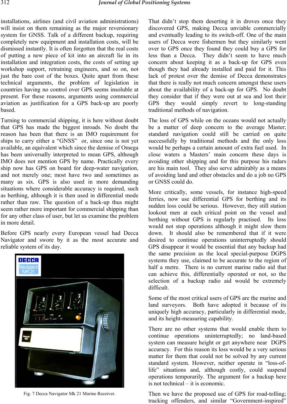 312 Journal of Global Positioning Systems installations, airlines (and civil aviation administrations) will insist on them remaining as the major reversionary system for GNSS. Talk of a different backup, requiring completely new equipment and installation costs, will be dismissed instantly. It is often forgotten that the real costs of putting a new piece of kit into an aircraft lie in its installation and integration costs, the costs of setting up workshop support, retraining engineers, and so on, not just the bare cost of the boxes. Quite apart from these technical arguments, the problem of legislation in countries having no control over GPS seems insoluble at present. For these reasons, arguments using commercial aviation as justification for a GPS back-up are poorly based. Turning to commercial shipping, it is here without doubt that GPS has made the biggest inroads. No doubt the reason has been that there is an IMO requirement for ships to carry either a “GNSS” or, since one is not yet available, an equivalent which since the demise of Omega has been universally interpreted to mean GPS, although IMO does not mention GPS by name. Practically every ship now has GPS on board for deep-water navigation, and not merely one; most have two and sometimes as many as six. GPS is also used in more demanding situations where considerable accuracy is required, such as berthing, although it is then used in differential mode rather than raw. The question of a back-up thus might seem rather more important for commercial shipping than for any other class of user, but let us examine the problem in more detail. Before GPS nearly every European vessel had Decca Navigator and swore by it as the most accurate and reliable system of its day. Fig. 7 Decca Navigator Mk 21 Marine Receiver. That didn’t stop them deserting it in droves once they discovered GPS, making Decca unviable commercially and eventually leading to its switch-off. One of the main users of Decca were fishermen but they similarly went over to GPS once they found they could buy a GPS for less than a Decca. They didn’t seem to have much concern about keeping it as a back-up for GPS even though they had already installed and paid for it. This lack of protest over the demise of Decca demonstrates that there is really not much concern amongst these users about the availability of a back-up for GPS. No doubt they consider that if they were out at sea and lost their GPS they would simply revert to long-standing traditional m e tho ds o f navigation. The loss of GPS while on the oceans would not actually be a matter of deep concern to the average Master; standard navigation could still be carried on quite successfully by traditional methods and the only loss would be perhaps a certain amount of extra fuel used. In close waters a Masters’ main concern these days is avoiding other shipping and for this purpose his radars are his main tool. They also serve admirably as a means of avoiding land and other obstacles and do a job no GPS or GNSS could do. More critically, some vessels, for instance high-speed ferries, now use differential GPS for berthing and its sudden loss could be serious. However, they still station lookout men at each critical point on the vessel and berthing without GPS is regularly practised. Its loss would not stop operations although it might slow them down. It should also be remembered that if it were desired to continue operations uninterruptedly should GPS disappear it would be essential that any backup had the same precision as the local special-purpose DGPS systems they use, claimed to be accurate to the region of half a metre. There is no current marine radio aid that can achieve this, differentially operated or not, so the selection of a backup radio aid would be extremely difficult. Some of the most critical users of GPS are the marine and land surveyors. Both have adopted it because of its uniquely high accuracy, particularly in differential mode, and its height-measuring capab ility. There are no other systems that would enable them to continue operations uninterruptedly; no land-based system can measure height or get anywhere near DGPS accuracy. For this reason its loss would be a very serious matter for them that could not be solved by any current standard system. However, neither operate in “loss-of- life” situations and, although costly, could suspend operations temporarily. The argument for a backup here is not technical – it is economic. Then we have the proposed use of GPS for road-tolling; tracking offenders, and similar “Government-inspired” 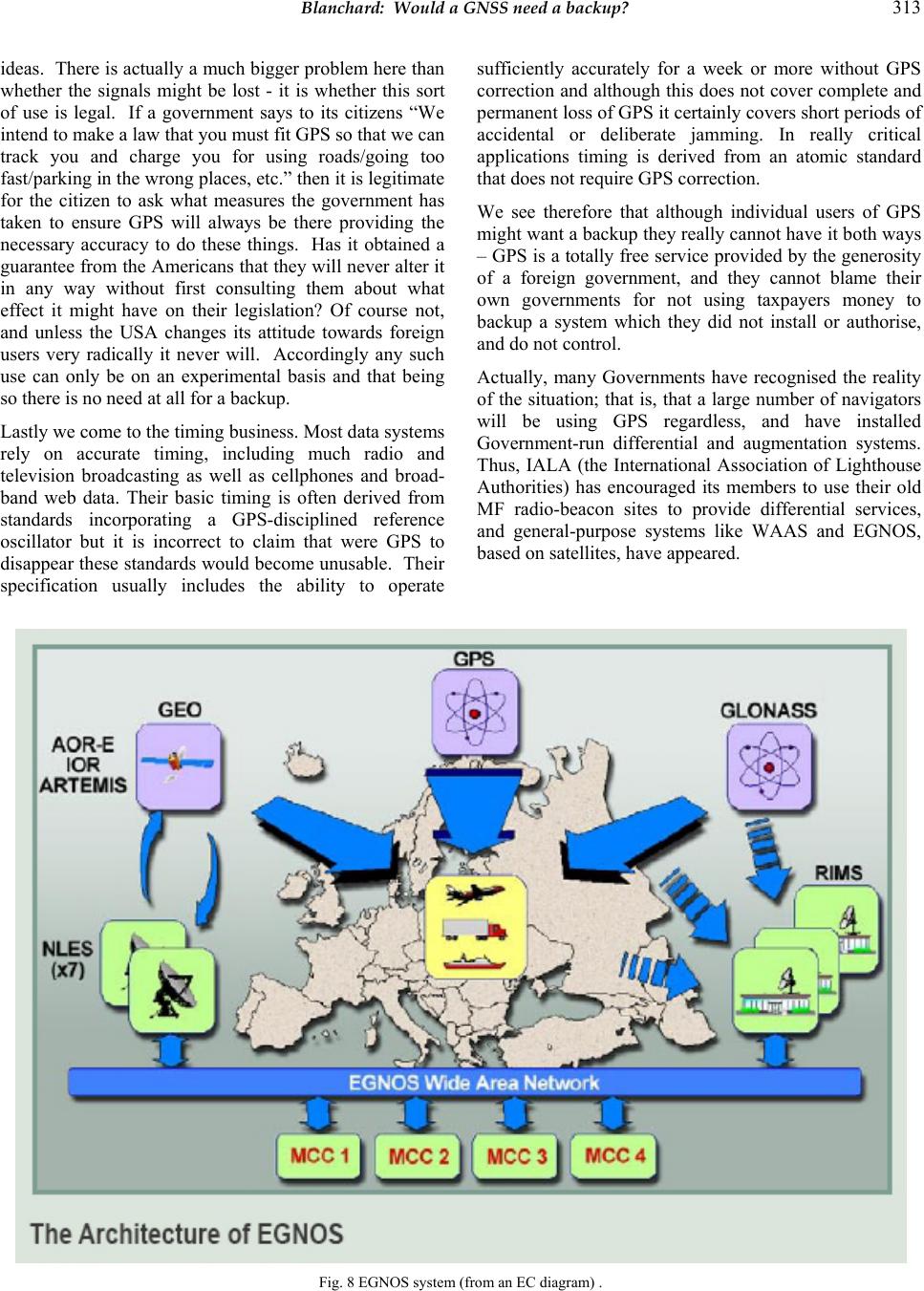 Blanchard: Would a GNSS need a backup? 313 ideas. There is actually a much bigger problem here than whether the signals might be lost - it is whether this sort of use is legal. If a government says to its citizens “We intend to make a law that you must fit GPS so that we can track you and charge you for using roads/going too fast/parking in the wrong places, etc.” then it is legitimate for the citizen to ask what measures the government has taken to ensure GPS will always be there providing the necessary accuracy to do these things. Has it obtained a guarantee from the Americans that they will never alter it in any way without first consulting them about what effect it might have on their legislation? Of course not, and unless the USA changes its attitude towards foreign users very radically it never will. Accordingly any such use can only be on an experimental basis and that being so there is no need at all for a backup. Lastly we come to the timing business. Most data systems rely on accurate timing, including much radio and television broadcasting as well as cellphones and broad- band web data. Their basic timing is often derived from standards incorporating a GPS-disciplined reference oscillator but it is incorrect to claim that were GPS to disappear these standards would become unusable. Their specification usually includes the ability to operate sufficiently accurately for a week or more without GPS correction and altho ugh this does not cover complete and permanent loss of GPS it certainly covers short periods of accidental or deliberate jamming. In really critical applications timing is derived from an atomic standard that does not require GPS correction. We see therefore that although individual users of GPS might want a backup they really cannot have it both ways – GPS is a totally free service provided by the generosity of a foreign government, and they cannot blame their own governments for not using taxpayers money to backup a system which they did not install or authorise, and do not control. Actually, many Governments have recognised the reality of the situation; that is, that a large number of navigators will be using GPS regardless, and have installed Government-run differential and augmentation systems. Thus, IALA (the International Association of Lighthouse Authorities) has encouraged its members to use their old MF radio-beacon sites to provide differential services, and general-purpose systems like WAAS and EGNOS, based on satellites, have appeared. Fig. 8 EGNOS system (from an EC diagram) . 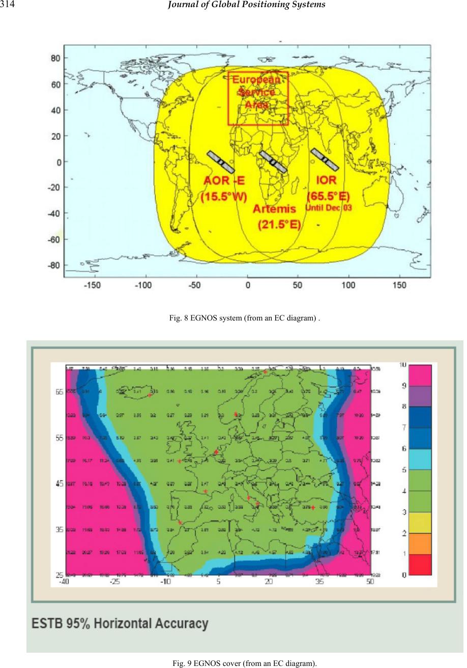 314 Journal of Global Positioning Systems Fig. 8 EGNOS system (from an EC diagram) . Fig. 9 EGNOS cover (from an EC diagram). 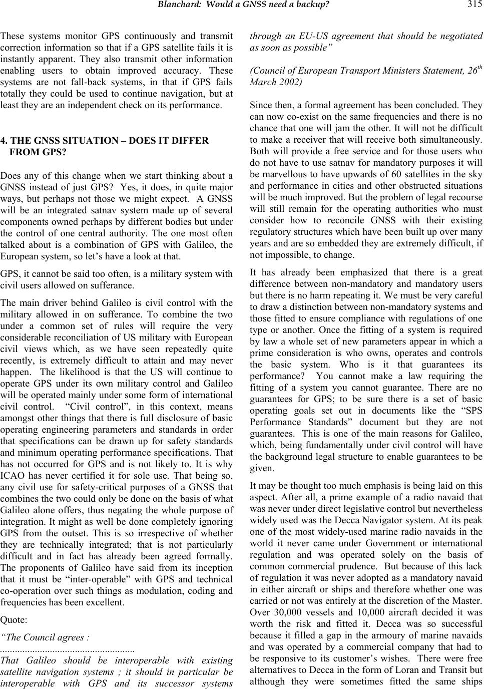 Blanchard: Would a GNSS need a backup? 315 These systems monitor GPS continuously and transmit correction information so that if a GPS satellite fails it is instantly apparent. They also transmit other information enabling users to obtain improved accuracy. These systems are not fall-back systems, in that if GPS fails totally they could be used to continue navigation, but at least they are an independent check on its performance. 4. THE GNSS SITUATION – DOES IT DIFFER FROM GPS? Does any of this change when we start thinking about a GNSS instead of just GPS? Yes, it does, in quite major ways, but perhaps not those we might expect. A GNSS will be an integrated satnav system made up of several components owned perhaps by different bodies but under the control of one central authority. The one most often talked about is a combination of GPS with Galileo, the European system, so let’s have a look at that. GPS, it cannot be said too often, is a military system with civil users allowed on sufferance. The main driver behind Galileo is civil control with the military allowed in on sufferance. To combine the two under a common set of rules will require the very considerable reconciliation of US military with European civil views which, as we have seen repeatedly quite recently, is extremely difficult to attain and may never happen. The likelihood is that the US will continue to operate GPS under its own military control and Galileo will be operated mainly under some form of international civil control. “Civil control”, in this context, means amongst other things that there is full disclosure of basic operating engineering parameters and standards in order that specifications can be drawn up for safety standards and minimum operating performance specifications. That has not occurred for GPS and is not likely to. It is why ICAO has never certified it for sole use. That being so, any civil use for safety-critical purposes of a GNSS that combines the two could only be done on the basis of what Galileo alone offers, thus negating the whole purpose of integration. It might as well be done completely ignoring GPS from the outset. This is so irrespective of whether they are technically integrated; that is not particularly difficult and in fact has already been agreed formally. The proponents of Galileo have said from its inception that it must be “inter-operable” with GPS and technical co-operation over such things as modulation, coding and frequencies has been excellent. Quote: “The Council agrees : ...................................................... That Galileo should be interoperable with existing satellite navigation systems ; it should in particular be interoperable with GPS and its successor systems through an EU-US agreement that should be negotiated as soon as possible” (Council of European Transport Ministers Statement, 26th March 2002) Since then, a formal agreement has been concluded. They can now co-exist on the same frequencies and there is no chance that one will jam the other. It will not be difficult to make a receiver that will receive both simultaneously. Both will provide a free service and for those users who do not have to use satnav for mandatory purposes it will be marvellous to have upwards of 60 satellites in the sky and performance in cities and other obstructed situations will be much improved. But the problem of legal recourse will still remain for the operating authorities who must consider how to reconcile GNSS with their existing regulatory structures which have been bu ilt up ov er many years and are so embedded they are extremely difficult, if not impossible, to change. It has already been emphasized that there is a great difference between non-mandatory and mandatory users but there is no harm repeating it. We must be very careful to draw a distinction between non-mandatory systems and those fitted to ensure compliance with regulations of one type or another. Once the fitting of a system is required by law a whole set of new parameters appear in which a prime consideration is who owns, operates and controls the basic system. Who is it that guarantees its performance? You cannot make a law requiring the fitting of a system you cannot guarantee. There are no guarantees for GPS; to be sure there is a set of basic operating goals set out in documents like the “SPS Performance Standards” document but they are not guarantees. This is one of the main reasons for Galileo, which, being fundamentally under civil control will have the background legal structure to enable guarantees to be given. It may be thought too much emphasis is being laid on this aspect. After all, a prime example of a radio navaid that was never under direct legislative control but nevertheless widely used was the Decca Navigator system. At its peak one of the most widely-used marine radio navaids in the world it never came under Government or international regulation and was operated solely on the basis of common commercial prudence. But because of this lack of regulation it was never adopted as a mandatory navaid in either aircraft or ships and therefore whether one was carried or not was entirely at the discretion of the Master. Over 30,000 vessels and 10,000 aircraft decided it was worth the risk and fitted it. Decca was so successful because it filled a gap in the armoury of marine navaids and was operated by a commercial company that had to be responsive to its customer’s wishes. There were free alternatives to Decca in the form of Loran and Transit but although they were sometimes fitted the same ships 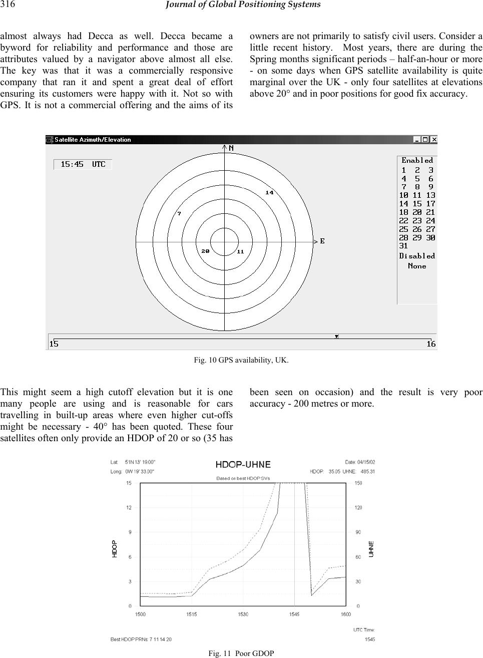 316 Journal of Global Positioning Systems almost always had Decca as well. Decca became a byword for reliability and performance and those are attributes valued by a navigator above almost all else. The key was that it was a commercially responsive company that ran it and spent a great deal of effort ensuring its customers were happy with it. Not so with GPS. It is not a commercial offering and the aims of its owners ar e not primarily to satisfy civil users. Consider a little recent history. Most years, there are during the Spring months significant periods – half-an-hour or more - on some days when GPS satellite availability is quite marginal over the UK - only four satellites at elevations above 20° and in poor positions for good fix accuracy. Fig. 10 GPS availability, UK. This might seem a high cutoff elevation but it is one many people are using and is reasonable for cars travelling in built-up areas where even higher cut-offs might be necessary - 40° has been quoted. These four satellites often on ly provide an HDOP of 20 or so (35 has been seen on occasion) and the result is very poor accuracy - 20 0 m et r e s or more. Fig. 11 Poor GDOP 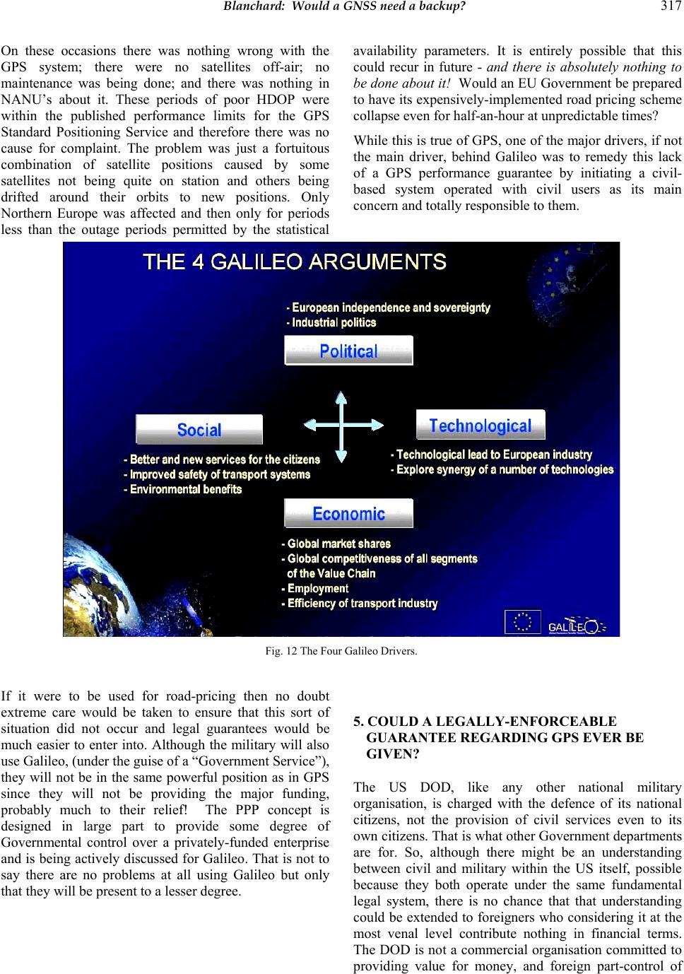 Blanchard: Would a GNSS need a backup? 317 On these occasions there was nothing wrong with the GPS system; there were no satellites off-air; no maintenance was being done; and there was nothing in NANU’s about it. These periods of poor HDOP were within the published performance limits for the GPS Standard Positioning Service and therefore there was no cause for complaint. The problem was just a fortuitous combination of satellite positions caused by some satellites not being quite on station and others being drifted around their orbits to new positions. Only Northern Europe was affected and then only for periods less than the outage periods permitted by the statistical availability parameters. It is entirely possible that this could recur in future - and there is absolutely nothing to be done about it! Would an EU Government be prepared to have its expensively-implemented road pricing scheme collapse even for half-an-hour at unpred ictable times? While this is true of GPS, one of the major drivers, if not the main driver, behind Galileo was to remedy this lack of a GPS performance guarantee by initiating a civil- based system operated with civil users as its main concern and totally resp onsible to them. Fig. 12 The Four Galileo Drivers. If it were to be used for road-pricing then no doubt extreme care would be taken to ensure that this sort of situation did not occur and legal guarantees would be much easier to enter into. Although the military will also use Galileo, (under the guise of a “Government Service”), they will not be in the same powerful position as in GPS since they will not be providing the major funding, probably much to their relief! The PPP concept is designed in large part to provide some degree of Governmental control over a privately-funded enterprise and is being actively discu ssed for Galileo. That is not to say there are no problems at all using Galileo but only that they will be present to a lesser degree. 5. COULD A L EG A L LY-ENFORCEABLE GUARANTEE REGARDING GPS EVER BE GIVEN? The US DOD, like any other national military organisation, is charged with the defence of its national citizens, not the provision of civil services even to its own citizens. That is what other Government departments are for. So, although there might be an understanding between civil and military within the US itself, possible because they both operate under the same fundamental legal system, there is no chance that that understanding could be extended to foreigners who considering it at the most venal level contribute nothing in financial terms. The DOD is not a commercial organisation committed to providing value for money, and foreign part-control of 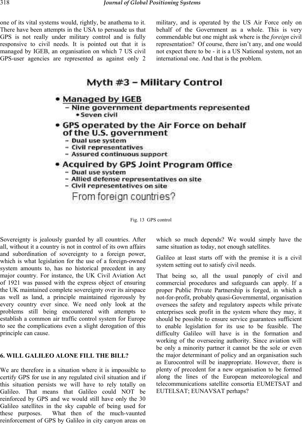 318 Journal of Global Positioning Systems one of its vital systems would, rightly, be anathema to it. There have been attempts in the USA to persuade us that GPS is not really under military control and is fully responsive to civil needs. It is pointed out that it is managed by IGEB, an organisation on which 7 US civil GPS-user agencies are represented as against only 2 military, and is operated by the US Air Force only on behalf of the Government as a whole. This is very commendable but one might ask where is the foreign civil representation? Of cour se, there isn’t any, an d one would not expect there to be - it is a US National system, not an international one. And that is the problem. Fig. 13 GPS control Sovereignty is jealously guarded by all countries. After all, without it a country is not in co ntrol of its own affairs and subordination of sovereignty to a foreign power, which is what legislation for the use of a foreign-owned system amounts to, has no historical precedent in any major country. For instance, the UK Civil Aviation Act of 1921 was passed with the express object of ensuring the UK maintained complete so vereignty over its airsp ace as well as land, a principle maintained rigorously by every country ever since. We need only look at the problems still being encountered with attempts to establish a common air traffic control system for Europe to see the complications even a slight derogation of this principle can cause. 6. WILL GALILEO ALONE FILL THE BILL? We are therefore in a situation where it is impossible to certify GPS for use in any regulated civil situation and if this situation persists we will have to rely totally on Galileo. That means that Galileo could NOT be reinforced by GPS and we would still have only the 30 Galileo satellites in the sky capable of being used for these purposes. What then of the much-vaunted reinforcement of GPS by Galileo in city canyon areas on which so much depends? We would simply have the same situation as today, not enough satellites. Galileo at least starts off with the premise it is a civil system setting out to satisfy civil needs. That being so, all the usual panoply of civil and commercial procedures and safeguards can apply. If a proper Public Private Partnership is forged, in which a not-for-p r ofi t , pr o babl y quasi-Governmental, orga ni sat i o n oversees the safety and regulatory aspects while private enterprises seek profit in the system where they may, it should be possible to ensure service guarantees sufficient to enable legislation for its use to be feasible. The difficulty Galileo will have is in the formation and working of the overseeing authority. Since aviation will be only a minority partner it cannot be the sole or even the major determinant of policy and an organisation such as Eurocontrol will be inappropriate. However, there is plenty of precedent for a new organisation to be formed along the lines of the European meteorological and telecommunications satellite consortia EUMETSAT and EUTELSAT; EUNAVSAT perhaps?  Blanchard: Would a GNSS need a backup? 319 Fig. 14 Galileo aims. The EU need not prevent non- EU countries joining in, as already demonstrated by non-EU participation in these and other organisations. Although no doubt the usual tedious and lengthy consultation would be involved there appears to be no really fundamental problem preventing such an organisation being formed. Some political and sovereignty issues would still remain, of course, but in a less severe form considering the existence of the European Union. The big difference between these older organisations and EUNAVSAT would be that are no legal compulsion s surrounding them. It is not yet a jailing matter if you do not use EUTELSAT or EUMETSAT, but it might well become one if you refuse to have EUNAVSAT in your car! But a word of warning. Little is being said publicly ab out what type of organisation might eventually run Galileo, for all sorts of very good reasons. One is that it will take a very long time to thrash out and it would be premature to go on the record now. So the likelihood is that the initial operation of Galileo will be under the au spices of ESA as a test and trial system but for how long will that last? 20 years? While it is in the status of a T and T system no legislation at all could be passed so it might not be until 2030 or so we will have a fully civil-responsible Galileo run by a legally-responsible organisation and all its putative advantages secured. 7. 2010, GALILEO, GPS III, AND ALL THAT. Let us ignore such gloomy forebodings and assume that in 2010 we have a civilly-responsible Galileo system around which legislatio n could be framed but with which GPS is unusable in any leg islated situation . Unfortunately it will be a Catch-22 situation because the technical problems we already have with GPS will still exist - a restricted number of satellites causing non-performance in city areas - so no performance guarantee to adequate standards will be possible and that would prevent legislation anyway. And what of the millions of drivers who would have GPS-only receivers - are they to be told to get rid of them and fit new, certified, Galileo-only models when they would not see any significant difference in performance? At, possibly, A$2000 a time (it would be claimed certification costs are not negligible) when they can get GPS sets for a few hundreds? Aircraft do not experience the same restrictions on satellite visibility as cars and provided the legal situation is resolved the use of Galileo for approach and landing could, in principle, be authorised. So it might - for European and other Galileo-subscribing non-US commercial air traffic, but what about intercontinental traffic? The US would no doubt not want to authorise Galileo, not having any control over it over their own 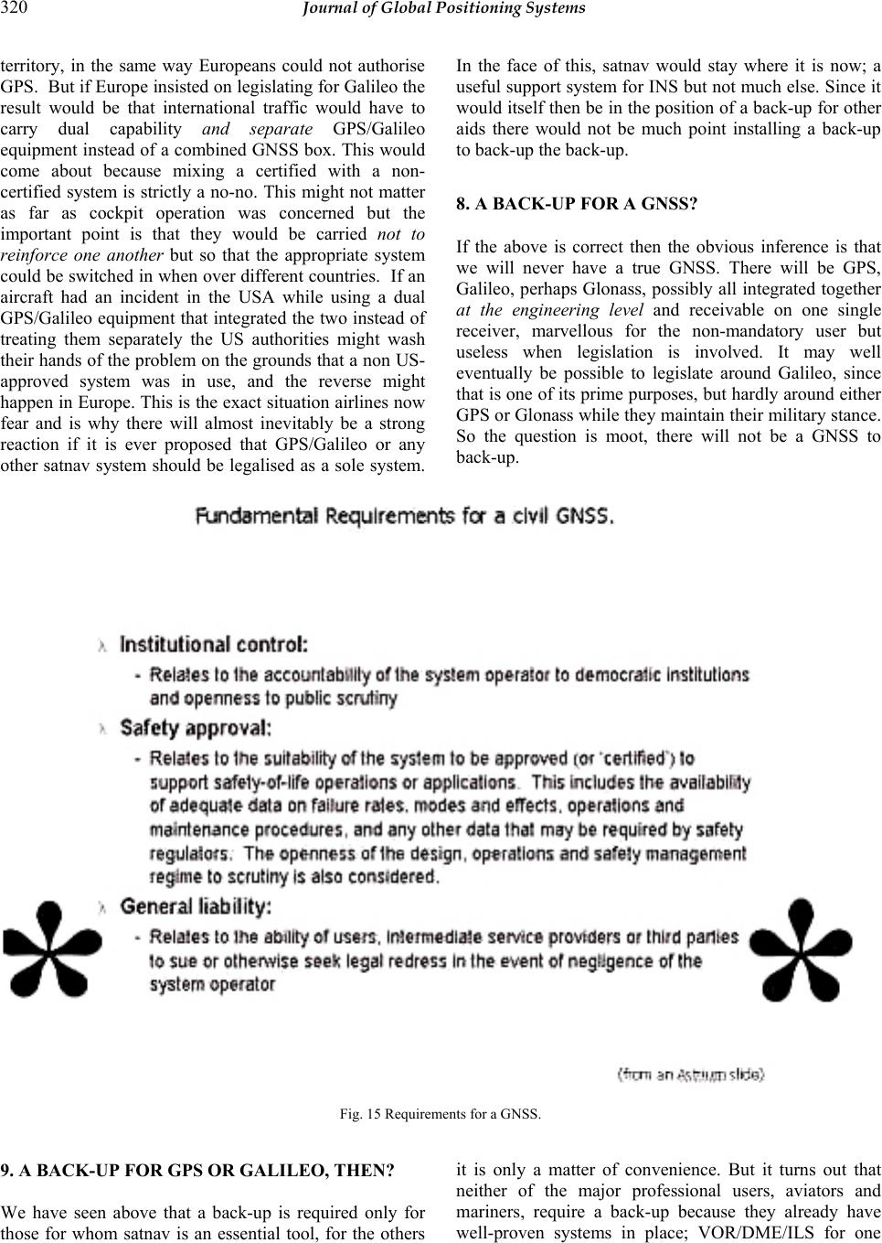 320 Journal of Global Positioning Systems territory, in the same way Europeans could not authorise GPS. But if Europe insisted on legislating for Galileo the result would be that international traffic would have to carry dual capability and separate GPS/Galileo equipment instead of a combined GNSS box. This would come about because mixing a certified with a non- certified system is strictly a no-no. This might not matter as far as cockpit operation was concerned but the important point is that they would be carried not to reinforce one another but so that the appropriate system could be switched in when over different countries. If an aircraft had an incident in the USA while using a dual GPS/Galileo equipment that integrated the two instead of treating them separately the US authorities might wash their hands of the problem on the grounds that a non US- approved system was in use, and the reverse might happen in Europe. This is the exact situation airlines now fear and is why there will almost inevitably be a strong reaction if it is ever proposed that GPS/Galileo or any other satnav system should be legalised as a sole system. In the face of this, satnav would stay where it is now; a useful support system fo r INS but not much else. Since it would itself then be in the position of a back-up for other aids there would not be much point installing a back-up to back-up the back-up. 8. A BACK-UP FOR A GNSS? If the above is correct then the obvious inference is that we will never have a true GNSS. There will be GPS, Galileo, perhaps Glonass, possibly all integrated together at the engineering level and receivable on one single receiver, marvellous for the non-mandatory user but useless when legislation is involved. It may well eventually be possible to legislate around Galileo, since that is one of its prime purposes, but hard ly around either GPS or Glonass while they maintain their military stan ce. So the question is moot, there will not be a GNSS to back-up. Fig. 15 Requirements f o r a GNSS. 9. A BACK-UP FOR GPS OR GALILEO, THEN? We have seen above that a back-up is required only for those for whom satnav is an essential tool, for the others it is only a matter of convenience. But it turns out that neither of the major professional users, aviators and mariners, require a back-up because they already have well-proven systems in place; VOR/DME/ILS for one  Kim et al: A Step, Stride and Heading Determination for the Pedestrian Navigation System 321 and radar for the other. For “voluntary” users, no back- up is required either because it is not generally a safety matter. The cases of amateur sailors and aviators who might get lost if they suddenly lose their satnav are the “hard cases” that make bad law. What is it that might cause them to lose their satnav anyway? Ignoring sillinesses like failing to carry spare batteries there is actually very little. The hard case we think about is where satnav has been working perfectly well on a trip and it suddenly disappears because all the satellites have been switched off. This is actually an impossibility because they could not be made to all disappear instantly; they would disappear one by one as they came within range of command stations that could command a switch-off. And it would be done only in a “grave emergency”, we are told, requiring an international situation so bad that it would have been general public knowledge well in advance and the possibility of a GPS switch-off well- known. As regards a total failure of the GPS command system, that is about as likely as all four engines failing simultaneously on a 747. Everything is duplicated, if not triplicated, and even if the command centre in Colorado were to fail completely, there is a reserve one in California. Failures in the satellites themselves are certainly possible and have occurred. The guard against these is proper monitoring and Galileo will have much improved built-in monitoring compared with GPS, the key being instant no tification to users of a failure through the satellite signals themselves transmitted from other satellites. What about “natural” causes? There are no significant propagation effects that could affect all visible satellites simultaneously. Scintillation can occasionally cause temporary fades of individual satellites but it is a very localised effect and there are always sufficient satellites in other parts of the sky. There are no precipitation static effects or skywaves as with low-frequency systems. The only significant impediments to propagation are blockage by buildings, trees, and other physical objects and the remedy is obvious. The ease of jamming the relatively weak signals emitted by satellites is often quoted as if no other radio signals are that weak. To take what might be called “official” jamming first, it is well-known that the preferred “official” method of denial of GPS service to an enemy is by local jamming to wipe out the SPS while leaving the PPS unaffected. If things are bad enough to require this then perhaps the non-military user should not be in the area in the first place, but in any case the possibility will have been well-publicised. Secondly, it has been claimed that a terrorist, or, perhaps worse, an electronic hobbyist would find it easy to jam GPS for his own purposes. The first thing to be said about this is that it would not affect professional users in the slightest - no aircraft or ship would be totally dependent on satnav as we have seen. The amateur seamen and aviators who might be relying on it rather more would not necessarily be affected very greatly either, since unless it were a major and very professional attack, they would eith er be out of range of a land-based jammer or would fly through the area of jamming relatively quickly. It is only local land-based users who would be really affected and for them there is no safety issue, on ly incon v enience. “Ho bbyist” j a mmers only do it for some easily-visible effect, but unlike jamming communications, jamming a navigation system does not show any su ch effects. It would be quite easy to jam an ILS for instance, with possibly more visible and instant effects even if it is only the sight of a jumbo having to go round again, but there have not been any recorded cases so far. As regards a radio-based backup for satnav to guard against jamming, that too could very likely be easily jammed. Loran- C has been quoted in this context but in fact over much of its coverage area its signals are not at all strong and they are just as liable to malicious jamming. 10. CONCL U SIO N S. The possibility of total and instantaneous failure of a satnav system like GPS or Galileo is so remote as to be discounted. No other radio navigation system has ever had the advantage of multiply-redundant independent transmitters unaffected by power supply outages, storm damage and insurrection. Natural causes of loss of signal are rare and are guarded against by the multiple satellite sources. Such possibilities of signal loss as there are come mainly from human activities that are limited in their effect. The reliability that results from these factors is such that no ground-based radio aid could possibly approach it and it would be ridiculous to have a back-up radio system that was less reliable than the system it was supporting. On examination, it is seen that in fact there are really very few users who actually need a new type of backup for satnav anyway, whether the satnav is GPS, Galileo or some combination that might be called a GNSS. For those for whom the loss of satnav would be important there are alternatives already available; for many others it is not a safety-of-life matter. It is hardly an effective use of resources to install a completely different system that would almost never be used. The important matter is not a back-up but putting into place the correct international arrangements to enable the genuine co-use of GPS, Galileo, and Glonass as one truly integrated GNSS system. |