Paper Menu >>
Journal Menu >>
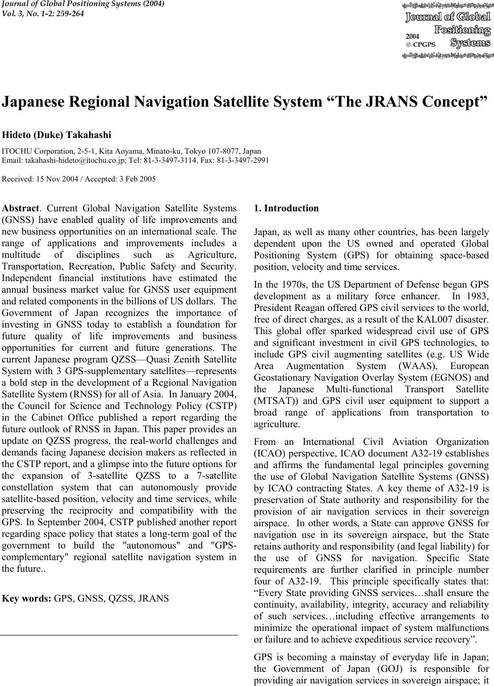 Journal of Global Positioning Systems (2004) Vol. 3, No. 1-2: 259-264 Japanese Regional Navigation Satellite System “The JRANS Concept” Hideto (Duke) Takahashi ITOCHU Corporation, 2-5-1, Kita Aoyama, Minato-ku, Tokyo 107-8077, Japan Email: takahashi-hideto@itochu.co.jp; Tel: 81-3-3497-3114, Fax: 81-3-3497-2991 Received: 15 Nov 2004 / Accepted: 3 Feb 2005 Abstract. Current Global Navigation Satellite Systems (GNSS) have enabled quality of life improvements and new business opportunities on an international scale. The range of applications and improvements includes a multitude of disciplines such as Agriculture, Transportation, Recreation, Public Safety and Security. Independent financial institutions have estimated the annual business market value for GNSS user equipment and related components in the billions of US dollars. The Government of Japan recognizes the importance of investing in GNSS today to establish a foundation for future quality of life improvements and business opportunities for current and future generations. The current Japanese program QZSS—Quasi Zenith Satellite System with 3 GPS-supplementary satellites—represents a bold step in the development of a Regional Navigation Satellite System (RNSS) for all of Asia. In January 2004, the Council for Science and Technology Policy (CSTP) in the Cabinet Office published a report regarding the future outlook of RNSS in Japan. This paper provides an update on QZSS progress, the real-world challenges and demands facing Japanese decision makers as reflected in the CSTP report, and a glimpse into the future options for the expansion of 3-satellite QZSS to a 7-satellite constellation system that can autonomously provide satellite-based position, velocity and time services, while preserving the reciprocity and compatibility with the GPS. In September 2004, CSTP published another report regarding space policy that states a long-term goal of the government to build the "autonomous" and "GPS- complementary" regional satellite navigation system in the future.. Key words: GPS, GNSS, QZSS, JRANS 1. Introduction Japan, as well as many other countries, has been largely dependent upon the US owned and operated Global Positioning System (GPS) for obtaining space-based position, velocity and time services. In the 1970s, the US Department of Defense began GPS development as a military force enhancer. In 1983, President Reagan offered GPS civil services to the world, free of direct charges, as a result of the KAL007 disaster. This global offer sparked widespread civil use of GPS and significant investment in civil GPS technologies, to include GPS civil augmenting satellites (e.g. US Wide Area Augmentation System (WAAS), European Geostationary Navigation Overlay System (EGNOS) and the Japanese Multi-functional Transport Satellite (MTSAT)) and GPS civil user equipment to support a broad range of applications from transportation to agriculture. From an International Civil Aviation Organization (ICAO) perspective, ICAO document A32-19 establishes and affirms the fundamental legal principles governing the use of Global Navigation Satellite Systems (GNSS) by ICAO contracting States. A key theme of A32-19 is preservation of State authority and responsibility for the provision of air navigation services in their sovereign airspace. In other words, a State can approve GNSS for navigation use in its sovereign airspace, but the State retains authority and responsibility (and legal liability) for the use of GNSS for navigation. Specific State requirements are further clarified in principle number four of A32-19. This principle specifically states that: “Every State providing GNSS services…shall ensure the continuity, availability, integrity, accuracy and reliability of such services…including effective arrangements to minimize the operational impact of system malfunctions or failure and to achieve expeditious service recovery”. GPS is becoming a mainstay of everyday life in Japan; the Government of Japan (GOJ) is responsible for providing air navigation services in sovereign airspace; it 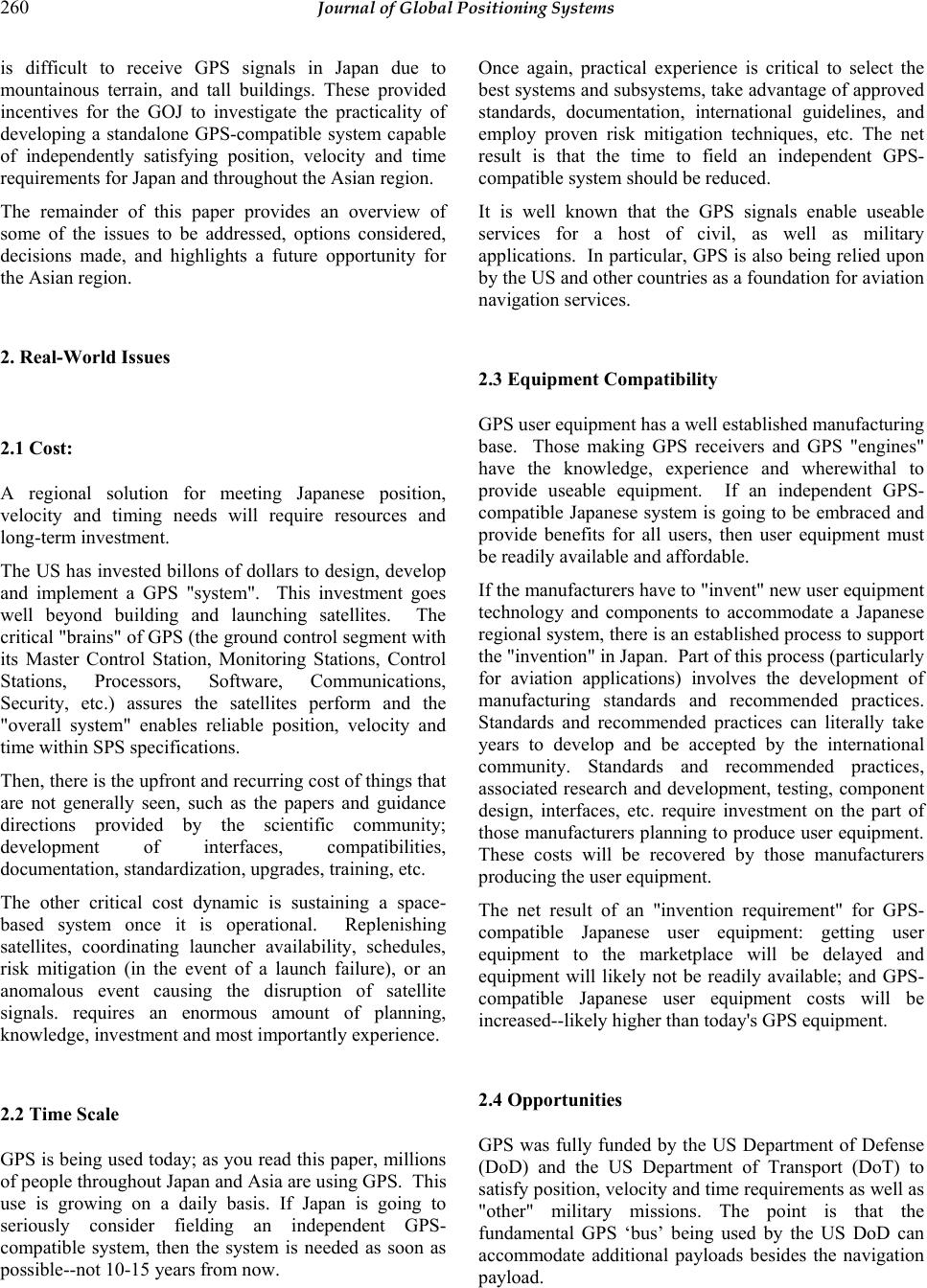 260 Journal of Global Positioning Systems is difficult to receive GPS signals in Japan due to mountainous terrain, and tall buildings. These provided incentives for the GOJ to investigate the practicality of developing a standalone GPS-compatible system capable of independently satisfying position, velocity and time requirements for Japan and throughout the Asian region. The remainder of this paper provides an overview of some of the issues to be addressed, options considered, decisions made, and highlights a future opportunity for the Asian region. 2. Real-World Issues 2.1 Cost: A regional solution for meeting Japanese position, velocity and timing needs will require resources and long-term investment. The US has invested billons of dollars to design, develop and implement a GPS "system". This investment goes well beyond building and launching satellites. The critical "brains" of GPS (the ground control segment with its Master Control Station, Monitoring Stations, Control Stations, Processors, Software, Communications, Security, etc.) assures the satellites perform and the "overall system" enables reliable position, velocity and time within SPS specifications. Then, there is the upfront and recurring cost of things that are not generally seen, such as the papers and guidance directions provided by the scientific community; development of interfaces, compatibilities, documentation, standardization, upgrades, training, etc. The other critical cost dynamic is sustaining a space- based system once it is operational. Replenishing satellites, coordinating launcher availability, schedules, risk mitigation (in the event of a launch failure), or an anomalous event causing the disruption of satellite signals. requires an enormous amount of planning, knowledge, investment and most importantly experience. 2.2 Time Scale GPS is being used today; as you read this paper, millions of people throughout Japan and Asia are using GPS. This use is growing on a daily basis. If Japan is going to seriously consider fielding an independent GPS- compatible system, then the system is needed as soon as possible--not 10-15 years from now. Once again, practical experience is critical to select the best systems and subsystems, take advantage of approved standards, documentation, international guidelines, and employ proven risk mitigation techniques, etc. The net result is that the time to field an independent GPS- compatible system should be reduced. It is well known that the GPS signals enable useable services for a host of civil, as well as military applications. In particular, GPS is also being relied upon by the US and other countries as a foundation for aviation navigation services. 2.3 Equipment Compatibility GPS user equipment has a well established manufacturing base. Those making GPS receivers and GPS "engines" have the knowledge, experience and wherewithal to provide useable equipment. If an independent GPS- compatible Japanese system is going to be embraced and provide benefits for all users, then user equipment must be readily available and affordable. If the manufacturers have to "invent" new user equipment technology and components to accommodate a Japanese regional system, there is an established process to support the "invention" in Japan. Part of this process (particularly for aviation applications) involves the development of manufacturing standards and recommended practices. Standards and recommended practices can literally take years to develop and be accepted by the international community. Standards and recommended practices, associated research and development, testing, component design, interfaces, etc. require investment on the part of those manufacturers planning to produce user equipment. These costs will be recovered by those manufacturers producing the user equipment. The net result of an "invention requirement" for GPS- compatible Japanese user equipment: getting user equipment to the marketplace will be delayed and equipment will likely not be readily available; and GPS- compatible Japanese user equipment costs will be increased--likely higher than today's GPS equipment. 2.4 Opportunities GPS was fully funded by the US Department of Defense (DoD) and the US Department of Transport (DoT) to satisfy position, velocity and time requirements as well as "other" military missions. The point is that the fundamental GPS ‘bus’ being used by the US DoD can accommodate additional payloads besides the navigation payload. 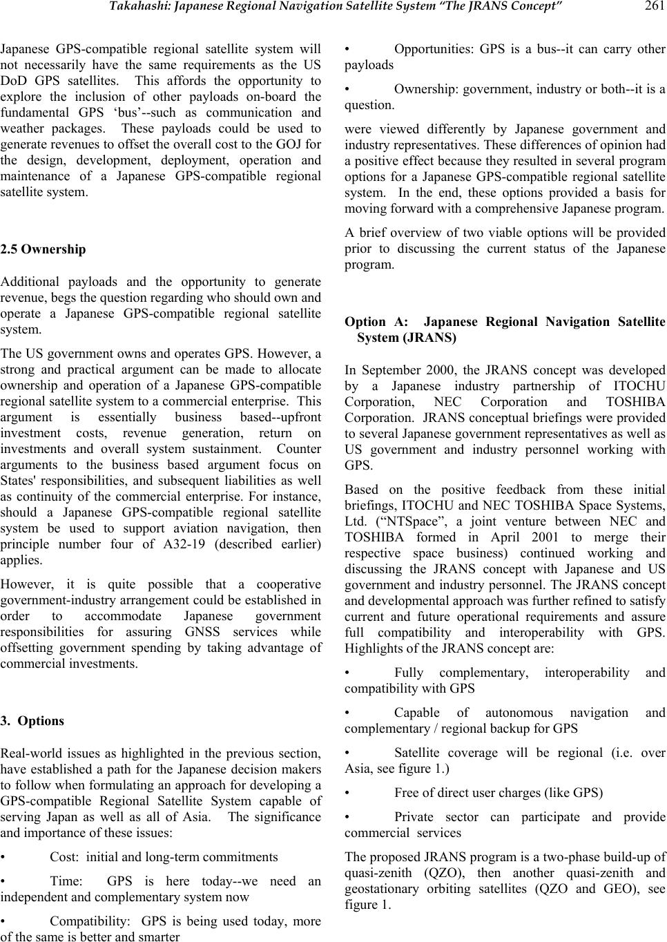 Takahashi: Japanese Regional Navigation Satellite System “The JRANS Concept” 261 Japanese GPS-compatible regional satellite system will not necessarily have the same requirements as the US DoD GPS satellites. This affords the opportunity to explore the inclusion of other payloads on-board the fundamental GPS ‘bus’--such as communication and weather packages. These payloads could be used to generate revenues to offset the overall cost to the GOJ for the design, development, deployment, operation and maintenance of a Japanese GPS-compatible regional satellite system. 2.5 Ownership Additional payloads and the opportunity to generate revenue, begs the question regarding who should own and operate a Japanese GPS-compatible regional satellite system. The US government owns and operates GPS. However, a strong and practical argument can be made to allocate ownership and operation of a Japanese GPS-compatible regional satellite system to a commercial enterprise. This argument is essentially business based--upfront investment costs, revenue generation, return on investments and overall system sustainment. Counter arguments to the business based argument focus on States' responsibilities, and subsequent liabilities as well as continuity of the commercial enterprise. For instance, should a Japanese GPS-compatible regional satellite system be used to support aviation navigation, then principle number four of A32-19 (described earlier) applies. However, it is quite possible that a cooperative government-industry arrangement could be established in order to accommodate Japanese government responsibilities for assuring GNSS services while offsetting government spending by taking advantage of commercial investments. 3. Options Real-world issues as highlighted in the previous section, have established a path for the Japanese decision makers to follow when formulating an approach for developing a GPS-compatible Regional Satellite System capable of serving Japan as well as all of Asia. The significance and importance of these issues: • Cost: initial and long-term commitments • Time: GPS is here today--we need an independent and complementary system now • Compatibility: GPS is being used today, more of the same is better and smarter • Opportunities: GPS is a bus--it can carry other payloads • Ownership: government, industry or both--it is a question. were viewed differently by Japanese government and industry representatives. These differences of opinion had a positive effect because they resulted in several program options for a Japanese GPS-compatible regional satellite system. In the end, these options provided a basis for moving forward with a comprehensive Japanese program. A brief overview of two viable options will be provided prior to discussing the current status of the Japanese program. Option A: Japanese Regional Navigation Satellite System (JRANS) In September 2000, the JRANS concept was developed by a Japanese industry partnership of ITOCHU Corporation, NEC Corporation and TOSHIBA Corporation. JRANS conceptual briefings were provided to several Japanese government representatives as well as US government and industry personnel working with GPS. Based on the positive feedback from these initial briefings, ITOCHU and NEC TOSHIBA Space Systems, Ltd. (“NTSpace”, a joint venture between NEC and TOSHIBA formed in April 2001 to merge their respective space business) continued working and discussing the JRANS concept with Japanese and US government and industry personnel. The JRANS concept and developmental approach was further refined to satisfy current and future operational requirements and assure full compatibility and interoperability with GPS. Highlights of the JRANS concept are: • Fully complementary, interoperability and compatibility with GPS • Capable of autonomous navigation and complementary / regional backup for GPS • Satellite coverage will be regional (i.e. over Asia, see figure 1.) • Free of direct user charges (like GPS) • Private sector can participate and provide commercial services The proposed JRANS program is a two-phase build-up of quasi-zenith (QZO), then another quasi-zenith and geostationary orbiting satellites (QZO and GEO), see figure 1.  262 Journal of Global Positioning Systems Fig. 1a JRANS: PHASE 1--three Satellites Quasi-Zenith Orbit For a satellite navigation receiver to calculate a solution, four satellite signals in view with good geometry must be received to determine latitude, longitude, altitude and time. Satellite signals are “line-of sight” transmissions and can be easily blocked by high terrain, buildings, etc. This blocking of the signals is referred to as masking. Use of GPS in Japan can be difficult because of this masking situation. Natural geographic features, such as mountainous terrain and manmade features, such as tall buildings often render GPS services unavailable in the most critical of situations. The advantage of a fully populated (7 satellite) constellation is having four satellites in view, at high mask angles, broadcasting GPS-type information, being controlled by Japan, and in coordination with the U.S. under the bilateral security treaty. Fig 1b JRANS: PHASE 2—four Satellites QZO and GEO Having four Japanese GPS-compatible satellites in view at higher elevations is particularly beneficial for those operating in mountainous areas and "urban canyons", as illustrated by Figure 2: Fig 2: An example of masking in the urban canyon. For GNSS users in Asia, there will also be a significant improvement in overall end state user performance as a result of better geometric dilution of precision (GDOP). Recall, GDOP is all geometric factors that degrade the accuracy of position fixes derived from externally referenced navigation systems. 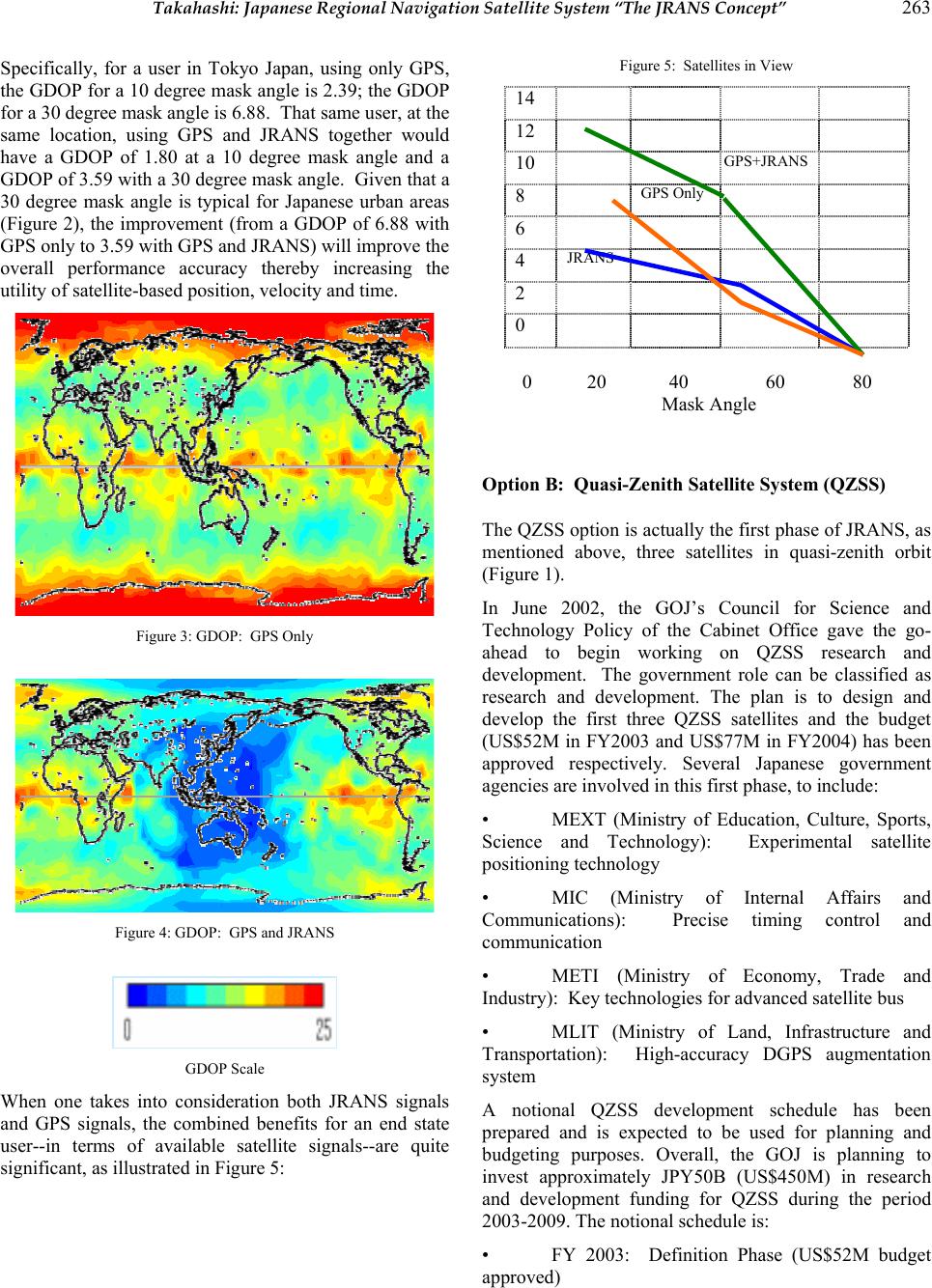 Takahashi: Japanese Regional Navigation Satellite System “The JRANS Concept” 263 Specifically, for a user in Tokyo Japan, using only GPS, the GDOP for a 10 degree mask angle is 2.39; the GDOP for a 30 degree mask angle is 6.88. That same user, at the same location, using GPS and JRANS together would have a GDOP of 1.80 at a 10 degree mask angle and a GDOP of 3.59 with a 30 degree mask angle. Given that a 30 degree mask angle is typical for Japanese urban areas (Figure 2), the improvement (from a GDOP of 6.88 with GPS only to 3.59 with GPS and JRANS) will improve the overall performance accuracy thereby increasing the utility of satellite-based position, velocity and time. Figure 3: GDOP: GPS Only Figure 4: GDOP: GPS and JRANS GDOP Scale When one takes into consideration both JRANS signals and GPS signals, the combined benefits for an end state user--in terms of available satellite signals--are quite significant, as illustrated in Figure 5: Figure 5: Satellites in View 14 12 10 GPS+JRANS 8 GPS Only 6 4 JRANS 2 0 0 20 40 60 80 Mask Angle Option B: Quasi-Zenith Satellite System (QZSS) The QZSS option is actually the first phase of JRANS, as mentioned above, three satellites in quasi-zenith orbit (Figure 1). In June 2002, the GOJ’s Council for Science and Technology Policy of the Cabinet Office gave the go- ahead to begin working on QZSS research and development. The government role can be classified as research and development. The plan is to design and develop the first three QZSS satellites and the budget (US$52M in FY2003 and US$77M in FY2004) has been approved respectively. Several Japanese government agencies are involved in this first phase, to include: • MEXT (Ministry of Education, Culture, Sports, Science and Technology): Experimental satellite positioning technology • MIC (Ministry of Internal Affairs and Communications): Precise timing control and communication • METI (Ministry of Economy, Trade and Industry): Key technologies for advanced satellite bus • MLIT (Ministry of Land, Infrastructure and Transportation): High-accuracy DGPS augmentation system A notional QZSS development schedule has been prepared and is expected to be used for planning and budgeting purposes. Overall, the GOJ is planning to invest approximately JPY50B (US$450M) in research and development funding for QZSS during the period 2003-2009. The notional schedule is: • FY 2003: Definition Phase (US$52M budget approved)  264 Journal of Global Positioning Systems • FY 2004: Research & Development Phase (US$77M budget approved) • FY 2005-2008: Engineering & Manufacturing Phase • FY 2009: 1st Satellite Launch From a commercial perspective, and in addition to the basic navigation functions that will be fully compatible with GPS, QZSS can provide communication services, broadcasting services and differential GPS services. In November 2002, in response to these commercial opportunities, Japanese industry jointly formed the Advanced Satellite Business Corporation (ASBC) to conduct the feasibility study for determining the opportunities of using QZSS to provide commercial services, such as S-band communications and broadcasting for mobile users. 4. Current Status As indicated in the previous section, the GOJ has committed resources to begin the design and development of a GPS-compatible Regional Satellite System capable of serving Japan as well as all of Asia. It is also evident that the design and development road will be lengthy without support from the US. Both Japanese government and industry recognize the importance of working cooperatively with US government and industry. As early as April 2002, ITOCHU and NTSpace have been making public presentations in the US regarding Japanese planning efforts and opportunities for US-Japanese government and commercial cooperation. From a government-to-government perspective, on 22 September, 1998 a US-Japan GPS partnership was forged when President William Clinton and Prime Minister Keizou Obuchi issued a joint statement regarding cooperation in the use of the GPS standard positioning service. Taking the statement, US-Japan GPS Plenary Meetings have been held to further harmonize joint activities. In addition, the Plenary agreed to form a Joint Technical Working Group to further the close cooperation between the US and Japan The Working Group goals are essentially to: • Assure maximum QZSS interoperability with GPS • Optimize the QZSS design to maximize GPS- QZSS performance in Asia • Increase commercial opportunities for GPS- QZSS applications 5. Future Outlook for Asia GPS reliance cannot be denied; neither can the significance of GPS for a broad spectrum of Asian users. In general, the aviation community appears to have a well established set of performance requirements for satellite- based navigation and are actively pursuing the development and implementation of civil augmentation systems. However, these "wide area coverage" augmentation systems: • US: Wide Area Augmentation Systems (WAAS) • Europe: European Geostationary Navigation Overlay System (EGNOS) • Japan: MTSAT Satellite-base Augmentation System (MSAS) • India: GPS/GLONASS and Geostationary Augmented Navigation (GAGAN) • Australia: Ground-based Regional Augmentation System (GRAS) All have one thing in common: the US GPS. If GPS signals "go away" then the utility of these augmentation systems will be close to zero. The Japanese government and industry personnel have carefully studied the significance of GPS on our daily lives, considered critical enabling issues, such as cost, time, GPS compatibility, additional business opportunities, and public / private ownership. A decision was made to move forward with a GPS- compatible regional system capable of providing independent, satellite-based position, velocity and time services while taking advantage of the broad range of benefits available from GPS signals and the current GPS industry.. For all of Asia, it is the most important fact that (in the near future) a combined US GPS and a standalone Japanese Regional Navigation Satellite System (RNSS) will provide a robust foundation for current and future generations of GPS users! |