Paper Menu >>
Journal Menu >>
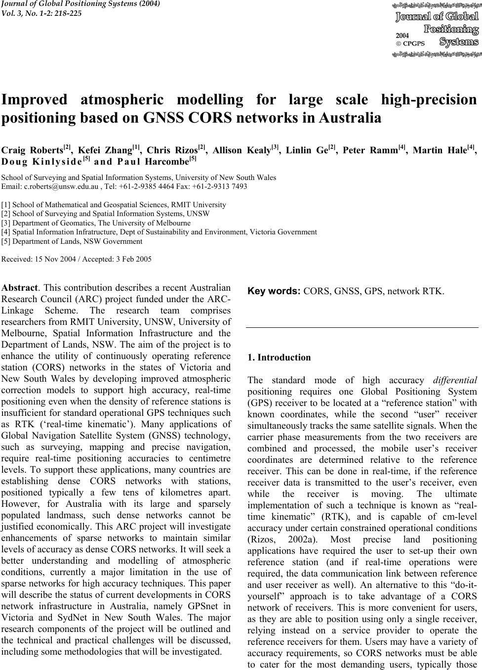 Journal of Global Positioning Systems (2004) Vol. 3, No. 1-2: 218-225 Improved atmospheric modelling for large scale high-precision positioning based on GNSS CORS networks in Australia Craig Roberts[2], Kefei Zhang[1], Chris Rizos[2], Allison Kealy[3], Linlin Ge[2], Peter Ramm[4], Martin Hale[4], Doug Kinlyside[5] and Paul Harcombe [5] School of Surveying and Spatial Information Systems, University of New South Wales Email: c.roberts@unsw.edu.au , Tel: +61-2-9385 4464 Fax: +61-2-9313 7493 [1] School of Mathematical and Geospatial Sciences, RMIT University [2] School of Surveying and Spatial Information Systems, UNSW [3] Department of Geomatics, The University of Melbourne [4] Spatial Information Infratructure, Dept of Sustainability and Environment, Victoria Government [5] Department of Lands, NSW Government Received: 15 Nov 2004 / Accepted: 3 Feb 2005 Abstract. This contribution describes a recent Australian Research Council (ARC) project funded under the ARC- Linkage Scheme. The research team comprises researchers from RMIT University, UNSW, University of Melbourne, Spatial Information Infrastructure and the Department of Lands, NSW. The aim of the project is to enhance the utility of continuously operating reference station (CORS) networks in the states of Victoria and New South Wales by developing improved atmospheric correction models to support high accuracy, real-time positioning even when the density of reference stations is insufficient for standard operational GPS techniques such as RTK (‘real-time kinematic’). Many applications of Global Navigation Satellite System (GNSS) technology, such as surveying, mapping and precise navigation, require real-time positioning accuracies to centimetre levels. To support these applications, many countries are establishing dense CORS networks with stations, positioned typically a few tens of kilometres apart. However, for Australia with its large and sparsely populated landmass, such dense networks cannot be justified economically. This ARC project will investigate enhancements of sparse networks to maintain similar levels of accuracy as dense CORS networks. It will seek a better understanding and modelling of atmospheric conditions, currently a major limitation in the use of sparse networks for high accuracy techniques. This paper will describe the status of current developments in CORS network infrastructure in Australia, namely GPSnet in Victoria and SydNet in New South Wales. The major research components of the project will be outlined and the technical and practical challenges will be discussed, including some methodologies that will be investigated. Key words: CORS, GNSS, GPS, network RTK. 1. Introduction The standard mode of high accuracy differential positioning requires one Global Positioning System (GPS) receiver to be located at a “reference station” with known coordinates, while the second “user” receiver simultaneously tracks the same satellite signals. When the carrier phase measurements from the two receivers are combined and processed, the mobile user’s receiver coordinates are determined relative to the reference receiver. This can be done in real-time, if the reference receiver data is transmitted to the user’s receiver, even while the receiver is moving. The ultimate implementation of such a technique is known as “real- time kinematic” (RTK), and is capable of cm-level accuracy under certain constrained operational conditions (Rizos, 2002a). Most precise land positioning applications have required the user to set-up their own reference station (and if real-time operations were required, the data communication link between reference and user receiver as well). An alternative to this “do-it- yourself” approach is to take advantage of a CORS network of receivers. This is more convenient for users, as they are able to position using only a single receiver, relying instead on a service provider to operate the reference receivers for them. Users may have a variety of accuracy requirements, so CORS networks must be able to cater for the most demanding users, typically those  Roberts et al: Improved atmospheric modelling for large scale high-precision positioning 219 seeking cm-level accuracy. However, CORS networks also permit innovative network-based techniques to be used, and this is discussed later in this section. High quality GPS reference stations have been established, in a sparse global network, since the late 1980s to support scientific applications such as tectonic/earthquake hazard research, geodetic reference system definition and maintenance, and atmospheric studies. These stations are typically located hundreds, or even thousands, of kilometres apart. Recently, networks of CORS are being established to support demanding navigation/positioning applications such as surveying and mapping, engineering machinery guidance, precision farming, harbour fleet management, rescue and emergency services, and structural monitoring. By improving the availability of reference station data for users that demand high positioning accuracy (and integrity), in real-time, the number and variety of applications can grow rapidly. CORS networks are therefore critical infrastructure enabling the basic utility of high precision positioning to a diverse range of users. Regional CORS networks are currently being established in many countries as a foundation for the establishment of a Spatial Data Infrastructure (Brown et al, 2002; Zhang et al, 2001; Rizos & Han, 2003). The distribution and density of a CORS network is constrained by the establishment costs per reference station, the areal extent to be serviced and the positioning accuracy requirements of the most demanding users (it is assumed that if the highest accuracy requirements are satisfied, all less demanding requirements can be easily met). Ideally, a dense network of reference receivers would be established and able to satisfy cm-level user accuracy requirements. Existing CORS networks in, for example, Germany, UK and Japan are sufficiently dense to restrict the maximum baseline length between a user and nearby reference station to well under 40km, which is often sufficient for cm-level accuracy techniques based on a single reference station, using high quality (dual- frequency) receivers that permit rapid “ambiguity resolution” (AR). However, as the inter-receiver distance increases, the residual atmospheric biases (due to differential ionospheric and tropospheric delay of the GPS satellite signals) in the double-differenced GPS observables (the standard observation model used for carrier phase-based positioning – Dedes & Rizos, 2002) increases, making AR more difficult (and even impossible using current rapid positioning techniques). Hence this distance constraint for rapid AR makes accurate positioning with respect to sparse CORS networks problematic. This has profound ramifications in Australia due to its large areal extent and relatively sparse population. The aim of this project is to enhance the utility of CORS networks in Australia, by developing new GPS atmospheric correction models to support cm-level, real- time positioning even when the density of reference stations is insufficient for standard operational techniques. 2. Status of CORS networks in Australia In the early 1990s, the Australian Regional GPS Network was established to support geodetic applications, and now consists of 16 reference stations on mainland Australia (with an average spacing of one thousand kilometres). A CORS network to support surveying, mapping and high-end navigation users was first established in 1994 when Victoria’s GPSnet was deployed (Hale, 2000). It has since grown to 19 reference stations with a regional and rural network coverage and a denser Melbourne and Environs network providing online GPS data access (www.land.vic.gov.au/GPSnet). Users can combine these files with GPS data collected across Victoria, for post-processing to obtain cm-level accuracy position results (see Figure 1). To date, this is the only state-wide CORS network in Australia. Figure 1 Current Status of Victoria’s Rural and Regional GPSnet network infrastructure CORS networks around the world will be progressively upgraded to provide a real-time capability for high-end users (Rizos, 2002b). This is also true of Victoria’s GPSnet, with eight stations currently broadcasting (single-reference) RTK corrections to local users. However, the distance-dependent atmospheric biases referred to earlier, restrict the length of GPS baselines, thereby limiting the applications of RTK techniques to within 10-15km of a broadcasting reference station. As the average reference station spacing in GPSnet is of the order of 100km (except in the Melbourne area where the spacing decreases to about 50km), there remain large areas of Victoria where RTK cannot be used (Roberts et al, 2003). 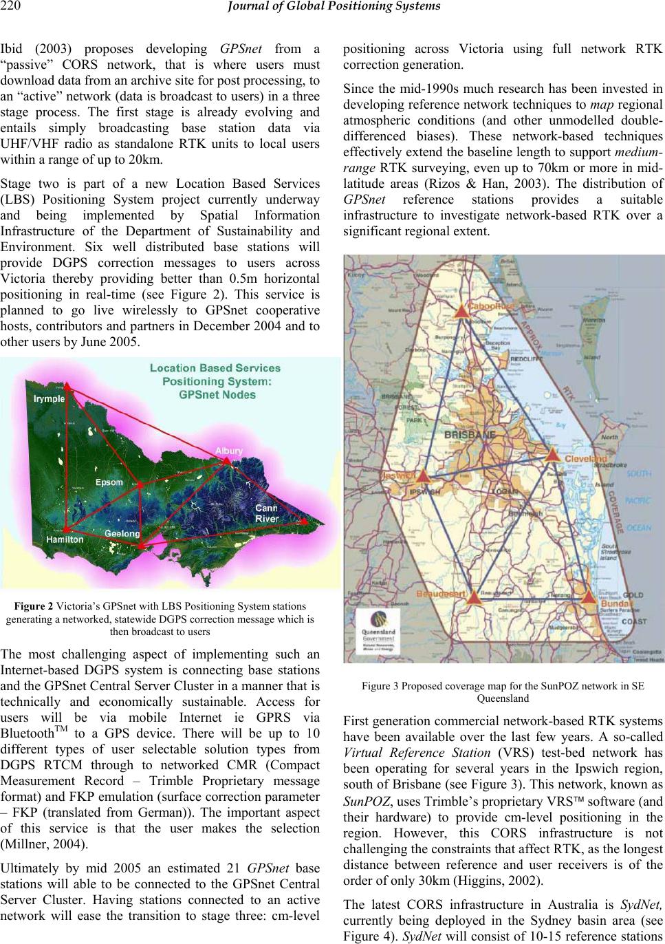 220 Journal of Global Positioning Systems Ibid (2003) proposes developing GPSnet from a “passive” CORS network, that is where users must download data from an archive site for post processing, to an “active” network (data is broadcast to users) in a three stage process. The first stage is already evolving and entails simply broadcasting base station data via UHF/VHF radio as standalone RTK units to local users within a range of up to 20km. Stage two is part of a new Location Based Services (LBS) Positioning System project currently underway and being implemented by Spatial Information Infrastructure of the Department of Sustainability and Environment. Six well distributed base stations will provide DGPS correction messages to users across Victoria thereby providing better than 0.5m horizontal positioning in real-time (see Figure 2). This service is planned to go live wirelessly to GPSnet cooperative hosts, contributors and partners in December 2004 and to other users by June 2005. Figure 2 Victoria’s GPSnet with LBS Positioning System stations generating a networked, statewide DGPS correction message which is then broadcast to users The most challenging aspect of implementing such an Internet-based DGPS system is connecting base stations and the GPSnet Central Server Cluster in a manner that is technically and economically sustainable. Access for users will be via mobile Internet ie GPRS via BluetoothTM to a GPS device. There will be up to 10 different types of user selectable solution types from DGPS RTCM through to networked CMR (Compact Measurement Record – Trimble Proprietary message format) and FKP emulation (surface correction parameter – FKP (translated from German)). The important aspect of this service is that the user makes the selection (Millner, 2004). Ultimately by mid 2005 an estimated 21 GPSnet base stations will able to be connected to the GPSnet Central Server Cluster. Having stations connected to an active network will ease the transition to stage three: cm-level positioning across Victoria using full network RTK correction generation. Since the mid-1990s much research has been invested in developing reference network techniques to map regional atmospheric conditions (and other unmodelled double- differenced biases). These network-based techniques effectively extend the baseline length to support medium- range RTK surveying, even up to 70km or more in mid- latitude areas (Rizos & Han, 2003). The distribution of GPSnet reference stations provides a suitable infrastructure to investigate network-based RTK over a significant regional extent. Figure 3 Proposed coverage map for the SunPOZ network in SE Queensland First generation commercial network-based RTK systems have been available over the last few years. A so-called Virtual Reference Station (VRS) test-bed network has been operating for several years in the Ipswich region, south of Brisbane (see Figure 3). This network, known as SunPOZ, uses Trimble’s proprietary VRS software (and their hardware) to provide cm-level positioning in the region. However, this CORS infrastructure is not challenging the constraints that affect RTK, as the longest distance between reference and user receivers is of the order of only 30km (Higgins, 2002). The latest CORS infrastructure in Australia is SydNet, currently being deployed in the Sydney basin area (see Figure 4). SydNet will consist of 10-15 reference stations  Roberts et al: Improved atmospheric modelling for large scale high-precision positioning 221 and will service the eastern seaboard from Wollongong to Newcastle (Rizos et al, 2003). Like the SunPOZ VRS network, SydNet will be a CORS network designed from the very beginning to support real-time operations, in contrast to GPSnet, which, due to its initial development from 1994, is evolving toward real-time operations. However, the high density of SydNet stations is only intended to support research into new network-based GPS positioning techniques. This is possible because of the ability to “thin” the CORS network, and to use some SydNet stations as simulated user receivers for check purposes. Hence, although SydNet is an ideal test network for the proposed research, it is not a blueprint for a state- wide CORS network. The extension of the GPS network across the state of New South Wales would be based on receiver spacings similar to those of Victoria’s GPSnet (or even greater). Figure 4 Current SydNet configuration SydNet will provide network generated RTK corrections using the in-house software developed in cooperation with Nanyang Technical University (NTU), Singapore and currently in operation on the Singapore Integrated Multiple Reference Station Network (SIMRSN) (Goh, 2002). Corrections will be archived on an Internet server housed at the Network Control Centre (NCC) hosted by ac3 (host company) at the Australian Technology Park, Redfern. This is a secure site guaranteeing reliable operations for users. The base stations are located at the state government Rail Corporation owned train stations and linked to the NCC via the existing optical fibre network owned by the telecommunications provider Argus. In the first instance, users will access the correction messages from the Internet via a GPRS connection using CDMA, 3G or W-LAN. Other methods of broadcasting correction messages to users will be investigated as SydNet evolves. An initial seven station subset of SydNet will be launched at the GNSS2004 conference in Sydney. GPSnet, SunPOZ and SydNet all provide a public utility function supported by their respective state government departments (Department of Sustainability and Environment, Dept of Natural Resources, Mines & Energy, Qld and Dept of Lands, NSW respectively). However only SydNet (and to a lesser extent GPSnet) will perform a dual function as a research test-bed and public utility. SunPOZ is a proprietary system and relies on the manufacturer (Trimble) for further advances and enhancements. 3. Motivation and Aims for Research Project CORS networks have already been established in many countries, and these are likely to be upgraded to provide cm-level positioning accuracy to high-end users, even in real-time. One challenge is to make the spacing of reference receivers as great as possible, without sacrificing user accuracy and reliability. Most CORS networks currently offering network-RTK services have reference station spacings of a few tens of kilometres at most. Internationally, research is being undertaken to extend the station spacing, primarily through improved atmospheric (ionospheric and tropospheric) bias modelling. Achieving cm-level positioning accuracy over distances of 70km or more has not yet been verified on an operational basis (though university studies have demonstrated promising results for short trials with optimised research software). Using the commercially available Trimble VRS system, Higgins (2002) and Retscher (2002) have reported horizontal positioning accuracy of the order of ±5cm, for baselines up to 35km in length. Other challenges include improving the stochastic models for network-based positioning, extending the data modelling algorithms to new satellite signals [i.e. “GPS modernization” (McDonald, 2002); and GALILEO (Galileo, 2003)], determining which is the “best” correction message formats, and outputting the bias modelling results in appropriate forms for non- positioning users. Australia has already made significant contributions to CORS research since the late-1990s (see Rizos & Han, 2003, for an overview), and with access to Victoria’s GPSnet and NSW’s SydNet further improvements to real-time network positioning techniques can be expected. The fundamental research facilities to be used in this project represent a significant infrastructure investment by the two government partners, Department of Sustainability and Environment and Dept of Lands, NSW. The research team has identified several research areas, primarily concerned with improving or extending current GPS atmospheric bias models to; 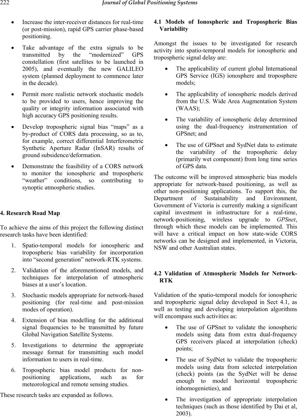 222 Journal of Global Positioning Systems • Increase the inter-receiver distances for real-time (or post-mission), rapid GPS carrier phase-based positioning. • Take advantage of the extra signals to be transmitted by the “modernized” GPS constellation (first satellites to be launched in 2005), and eventually the new GALILEO system (planned deployment to commence later in the decade). • Permit more realistic network stochastic models to be provided to users, hence improving the quality or integrity information associated with high accuracy GPS positioning results. • Develop tropospheric signal bias “maps” as a by-product of CORS data processing, so as to, for example, correct differential Interferometric Synthetic Aperture Radar (InSAR) results of ground subsidence/deformation. • Demonstrate the feasibility of a CORS network to monitor the ionospheric and tropospheric “weather” conditions, so contributing to synoptic atmospheric studies. 4. Research Road Map To achieve the aims of this project the following distinct research tasks have been identified: 1. Spatio-temporal models for ionospheric and tropospheric bias variability for incorporation into “second generation” network-RTK systems. 2. Validation of the aforementioned models, and techniques for interpolation of atmospheric biases at a user’s location. 3. Stochastic models appropriate for network-based positioning (for real-time and post-mission modes of operation). 4. Extension of bias modelling for the additional signal frequencies to be transmitted by future Global Navigation Satellite Systems. 5. Investigations to determine the appropriate message format for transmitting such model information to users in real-time. 6. Tropospheric bias model products for non- positioning applications, such as for meteorological and remote sensing studies. These research tasks are expanded as follows. 4.1 Models of Ionospheric and Tropospheric Bias Variability Amongst the issues to be investigated for research activity into spatio-temporal models for ionospheric and tropospheric signal delay are: • The applicability of current global International GPS Service (IGS) ionosphere and troposphere models; • The applicability of ionospheric models derived from the U.S. Wide Area Augmentation System (WAAS); • The variability of ionospheric delay determined using the dual-frequency instrumentation of GPSnet; and • The use of GPSnet and SydNet data to estimate the variability of the tropospheric delay (primarily wet component) from long time series of GPS data. The outcome will be improved atmospheric bias models appropriate for network-based positioning, as well as other non-positioning applications. To support this, the Department of Sustainability and Environment, Government of Victoria is currently making a significant capital investment in infrastructure for a real-time, network-positioning, wireless upgrade to GPSnet, through which these models can be implemented. This will have a critical impact on how state-wide CORS networks can be designed and implemented, in Victoria, NSW and other Australian states. 4.2 Validation of Atmospheric Models for Network- RTK Validation of the spatio-temporal models for ionospheric and tropospheric signal delay developed in Sect 4.1, as well as testing and developing interpolation algorithms will encompass such activities as: • The use of GPSnet to validate the ionospheric models using data from extra dual-frequency GPS receivers placed at interpolation (check) points; • The use of SydNet to validate the tropospheric models using data from selected interpolation (check) points (as the SydNet will be dense enough to model horizontal tropospheric inhomogenieties), and • The investigation of appropriate interpolation techniques (such as those identified by Dai et al, 2003). 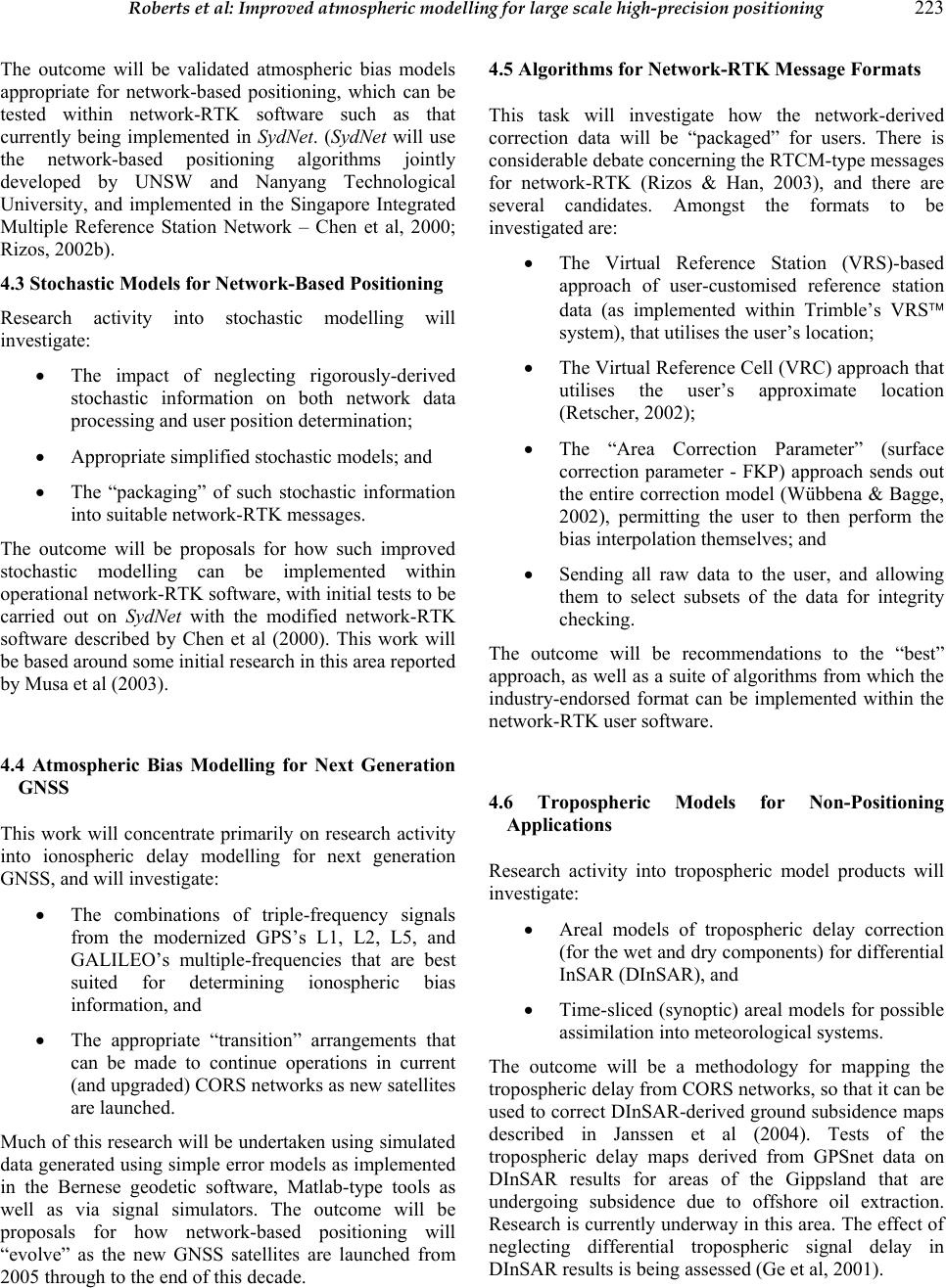 Roberts et al: Improved atmospheric modelling for large scale high-precision positioning 223 The outcome will be validated atmospheric bias models appropriate for network-based positioning, which can be tested within network-RTK software such as that currently being implemented in SydNet. (SydNet will use the network-based positioning algorithms jointly developed by UNSW and Nanyang Technological University, and implemented in the Singapore Integrated Multiple Reference Station Network – Chen et al, 2000; Rizos, 2002b). 4.3 Stochastic Models for Network-Based Positioning Research activity into stochastic modelling will investigate: • The impact of neglecting rigorously-derived stochastic information on both network data processing and user position determination; • Appropriate simplified stochastic models; and • The “packaging” of such stochastic information into suitable network-RTK messages. The outcome will be proposals for how such improved stochastic modelling can be implemented within operational network-RTK software, with initial tests to be carried out on SydNet with the modified network-RTK software described by Chen et al (2000). This work will be based around some initial research in this area reported by Musa et al (2003). 4.4 Atmospheric Bias Modelling for Next Generation GNSS This work will concentrate primarily on research activity into ionospheric delay modelling for next generation GNSS, and will investigate: • The combinations of triple-frequency signals from the modernized GPS’s L1, L2, L5, and GALILEO’s multiple-frequencies that are best suited for determining ionospheric bias information, and • The appropriate “transition” arrangements that can be made to continue operations in current (and upgraded) CORS networks as new satellites are launched. Much of this research will be undertaken using simulated data generated using simple error models as implemented in the Bernese geodetic software, Matlab-type tools as well as via signal simulators. The outcome will be proposals for how network-based positioning will “evolve” as the new GNSS satellites are launched from 2005 through to the end of this decade. 4.5 Algorithms for Network-RTK Message Formats This task will investigate how the network-derived correction data will be “packaged” for users. There is considerable debate concerning the RTCM-type messages for network-RTK (Rizos & Han, 2003), and there are several candidates. Amongst the formats to be investigated are: • The Virtual Reference Station (VRS)-based approach of user-customised reference station data (as implemented within Trimble’s VRS system), that utilises the user’s location; • The Virtual Reference Cell (VRC) approach that utilises the user’s approximate location (Retscher, 2002); • The “Area Correction Parameter” (surface correction parameter - FKP) approach sends out the entire correction model (Wübbena & Bagge, 2002), permitting the user to then perform the bias interpolation themselves; and • Sending all raw data to the user, and allowing them to select subsets of the data for integrity checking. The outcome will be recommendations to the “best” approach, as well as a suite of algorithms from which the industry-endorsed format can be implemented within the network-RTK user software. 4.6 Tropospheric Models for Non-Positioning Applications Research activity into tropospheric model products will investigate: • Areal models of tropospheric delay correction (for the wet and dry components) for differential InSAR (DInSAR), and • Time-sliced (synoptic) areal models for possible assimilation into meteorological systems. The outcome will be a methodology for mapping the tropospheric delay from CORS networks, so that it can be used to correct DInSAR-derived ground subsidence maps described in Janssen et al (2004). Tests of the tropospheric delay maps derived from GPSnet data on DInSAR results for areas of the Gippsland that are undergoing subsidence due to offshore oil extraction. Research is currently underway in this area. The effect of neglecting differential tropospheric signal delay in DInSAR results is being assessed (Ge et al, 2001).  224 Journal of Global Positioning Systems 3. Concluding Remarks CORS networks in other countries are sufficiently dense to restrict the maximum baseline length between a user and nearby reference station to well under 40km. Under typical operational conditions this is usually adequate for cm-level positioning accuracy. Due to Australia’s large areal extent and relatively sparse population, the number of reference stations required for a state-wide network using existing techniques would therefore be uneconomical. One option would be to, rather than offer a state-wide service, provide the necessary station density within regions with high population densities. However, in Australia some of the most important users of satellite positioning technology are in precision agriculture and mining applications, and require infrastructure across large rural areas. This research is therefore of national significance as it will provide an infrastructure that benefits activities for rural and regional communities. To service these users adequately the state governments need to implement the outcomes proposed in this research project in order to capitalise on sparse CORS infrastructure. The primary outcome of the proposed research will be enhanced CORS operational algorithms and procedures, extending the capabilities of current commercially available network-based positioning systems such as VRS. Such a refinement will lead to “second generation” CORS networks, with sparser spacing of reference stations than current “first generation” VRS systems, without sacrificing performance (accuracy, time-to-AR, reliability, availability and integrity). Acknowledgements: The authors would like to gratefully acknowledge the research funds granted for this project through the Australian Research Council Linkage project LP0455170. References Brown, N., Kealy, A. & Williamson, I. (2002) Issues related to GPS phase observations for improved quality estimation, The Journal of Cartography, Australia, 31(2), 143-151. Chen, X., Han, S., Rizos, C. & Goh, P.C. (2000) Improving real-time positioning efficiency using the Singapore Integrated Multiple Reference Station Network (SIMRSN), 13th Int. Tech. Meeting of the Satellite Division of the U.S. Inst. of Navigation, Salt Lake City, Utah, 19-22 September, 9-18. Dai, L., Han, S., Wang, J., Rizos, C. (2002) Comparison of interpolation algorithms in network-based GPS techniques, Journal of Navigation, 50(4), pp 277 – 293. Dedes, G. & Rizos, C. (2002) GPS positioning models for single point and baseline solutions, Chapter 9 in Manual of Geospatial Science and Technology, J. Bossler, J. Jenson, R. McMaster & C. Rizos (eds.), Taylor & Francis Inc., ISBN 0-7484-0924-6, 114-126. Galileo (2003) http://europa.eu.int/comm/dgs/energy_transport/galileo/ind ex_en.htm Ge, L., Chen, H.Y., Han, S. & Rizos, C. (2001) Integrated GPS and Interferometric SAR techniques for highly dense crustal deformation monitoring, 14th Int. Tech. Meeting of the Satellite Division of the U.S. Inst. of Navigation, Salt Lake City, Utah, 11-14 September, 2552-2563. Goh, P.C. (2002) Development of an Integrated Multiple Base Station Infrastructure to support Concurrent High Precision Differential Positioning Applications, Nanyang Technical University, Internal Report. GPSnet (2004) http://land.vic.gov.au/GPSnet Hale, M. (2000) GPSnet: The next decade, paper presented at the Survey Conference of the Institution of Surveyors Victoria and the Institution of Engineering Surveyors Australia, Victoria Division, 27 May. Higgins, M. (2002) Australia’s changing surveying infrastructure from marks in the ground to virtual reference stations, FIG XXII International Congress, Washington, 19-26 April, TS5.6. Janssen, V., Ge, L. & Rizos, C. (2004) Tropospheric corrections to SAR interferometry from GPS observations, GPS Solutions, 8(3), 140 – 151. McDonald, K. (2002) The Modernization of GPS: Plans, new capabilities and the future relationship to Galileo, Journal of Global Positioning Systems, 1(1), 1-17. Millner, J. (2004) GPSnet Location Based Services Positioning System Project Manager, Personal communication Musa, T.A., Wang, J., Rizos, C. & Satirapod, C. (2003) Stochastic modelling for network-based GPS positioning, 6th Int. Symp. on Satellite Navigation Technology Including Mobile Positioning & Location Services, Melbourne, Australia, 22-25 July, CD-ROM proc., paper 41. Retscher, G. (2002) Accuracy performance of virtual reference station (VRS) networks, Journal of Global Positioning Systems, 1(1), 40-47. Rizos, C. (2002a) Making sense of the GPS techniques, Chapter 11 in Manual of Geospatial Science and Technology, J. Bossler, J. Jenson, R. McMaster & C. Rizos (eds.), Taylor & Francis Inc., ISBN 0-7484-0924-6, 146-161. Rizos, C. (2002b) Network RTK research and implementation: A geodetic perspective, Journal of Global Positioning Systems, 1(2), 144-150. Rizos, C., Kinlyside, D., Yan, T., Omar, S. & Musa, T.A. (2003) Implementing network RTK: The SydNet CORS infrastructure, 6th Int. Symp. on Satellite Navigation Technology Including Mobile Positioning & Location Services, Melbourne, Australia, 22-25 July, CD-ROM proc., paper 50.  Roberts et al: Improved atmospheric modelling for large scale high-precision positioning 225 Rizos, C. & Han, S. (2003) Reference station network based RTK systems - Concepts & progress, Wuhan University Journal of Nature Sciences, 8(2B), 566-574. Roberts, C., Zhang, K., Hale, M. & Millner, J. (2003) Towards real-time network-based RTK corrections for Victoria’s GPSnet, 6th Int. Symp. on Satellite Navigation Technology Including Mobile Positioning & Location Services, Melbourne, Australia, 22-25 July. Wübbena, G. & Bagge, A. (2002) RTCM Message Type 59– FKP for transmission of FKP, Version 1.0, Geo++ White Paper Nr. 2002.01, www.geopp.de/download/geopp-rtcm- fkp59.pdf Zhang, K., Talbot, N., Hale, M. & Millner, J. (2001) Victorian high precision permanent GPS tracking network system, 14th Int. Tech. Meeting of the Satellite Division of the U.S. Inst. of Navigation, Salt Lake City, Utah, 11-14 September, 3077-3085. |