Paper Menu >>
Journal Menu >>
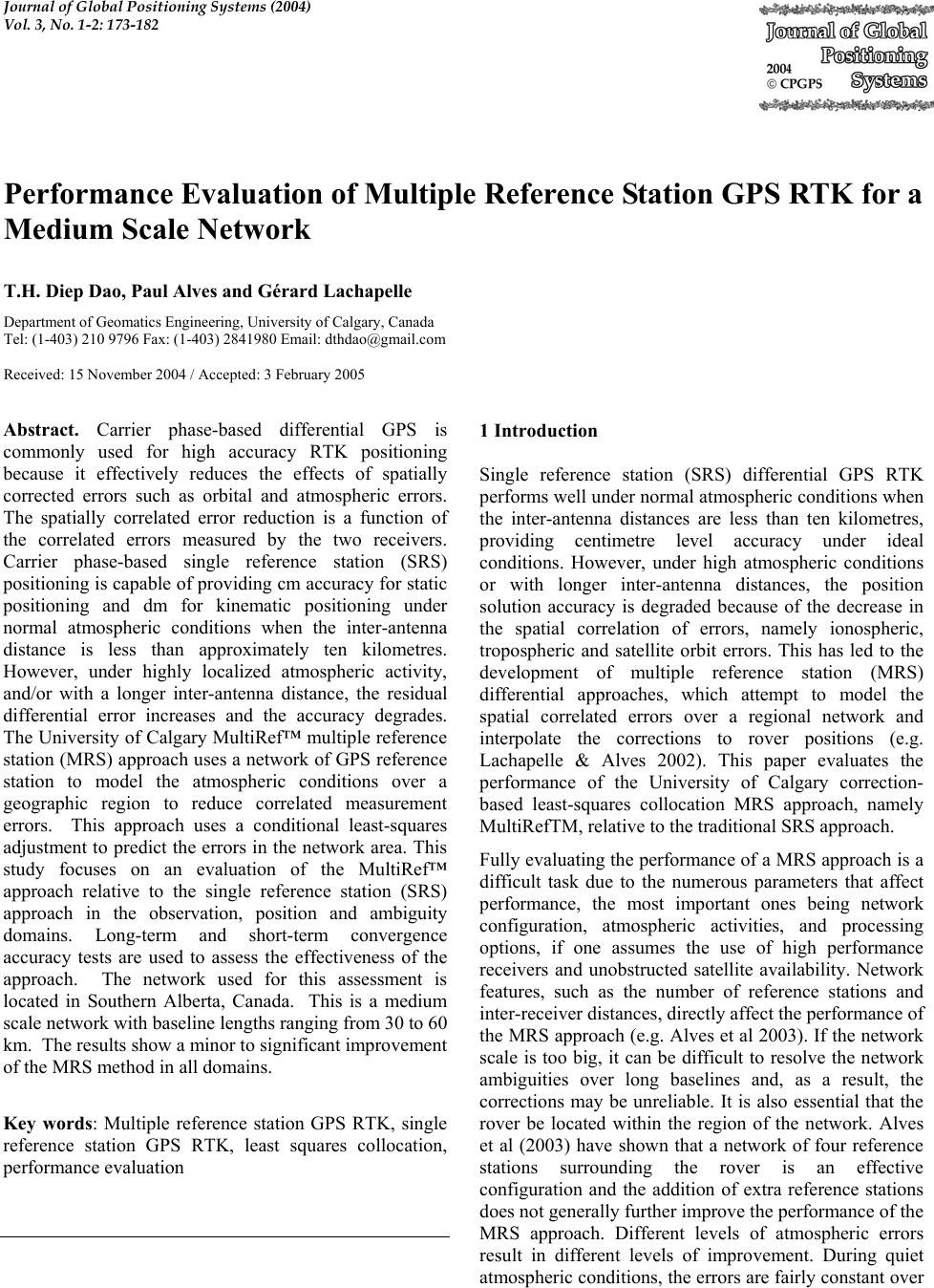 Journal of Global Positioning Systems (2004) Vol. 3, No. 1-2: 173-182 Performance Evaluation of Multiple Reference Station GPS RTK for a Medium Scale Network T.H. Diep Dao, Paul Alves and Gérard Lachapelle Department of Geomatics Engineering, University of Calgary, Canada Tel: (1-403) 210 9796 Fax: (1-403) 2841980 Email: dthdao@gmail.com Received: 15 November 2004 / Accepted: 3 February 2005 Abstract. Carrier phase-based differential GPS is commonly used for high accuracy RTK positioning because it effectively reduces the effects of spatially corrected errors such as orbital and atmospheric errors. The spatially correlated error reduction is a function of the correlated errors measured by the two receivers. Carrier phase-based single reference station (SRS) positioning is capable of providing cm accuracy for static positioning and dm for kinematic positioning under normal atmospheric conditions when the inter-antenna distance is less than approximately ten kilometres. However, under highly localized atmospheric activity, and/or with a longer inter-antenna distance, the residual differential error increases and the accuracy degrades. The University of Calgary MultiRef™ multiple reference station (MRS) approach uses a network of GPS reference station to model the atmospheric conditions over a geographic region to reduce correlated measurement errors. This approach uses a conditional least-squares adjustment to predict the errors in the network area. This study focuses on an evaluation of the MultiRef™ approach relative to the single reference station (SRS) approach in the observation, position and ambiguity domains. Long-term and short-term convergence accuracy tests are used to assess the effectiveness of the approach. The network used for this assessment is located in Southern Alberta, Canada. This is a medium scale network with baseline lengths ranging from 30 to 60 km. The results show a minor to significant improvement of the MRS method in all domains. Key words: Multiple reference station GPS RTK, single reference station GPS RTK, least squares collocation, performance evaluation 1 Introduction Single reference station (SRS) differential GPS RTK performs well under normal atmospheric conditions when the inter-antenna distances are less than ten kilometres, providing centimetre level accuracy under ideal conditions. However, under high atmospheric conditions or with longer inter-antenna distances, the position solution accuracy is degraded because of the decrease in the spatial correlation of errors, namely ionospheric, tropospheric and satellite orbit errors. This has led to the development of multiple reference station (MRS) differential approaches, which attempt to model the spatial correlated errors over a regional network and interpolate the corrections to rover positions (e.g. Lachapelle & Alves 2002). This paper evaluates the performance of the University of Calgary correction- based least-squares collocation MRS approach, namely MultiRefTM, relative to the traditional SRS approach. Fully evaluating the performance of a MRS approach is a difficult task due to the numerous parameters that affect performance, the most important ones being network configuration, atmospheric activities, and processing options, if one assumes the use of high performance receivers and unobstructed satellite availability. Network features, such as the number of reference stations and inter-receiver distances, directly affect the performance of the MRS approach (e.g. Alves et al 2003). If the network scale is too big, it can be difficult to resolve the network ambiguities over long baselines and, as a result, the corrections may be unreliable. It is also essential that the rover be located within the region of the network. Alves et al (2003) have shown that a network of four reference stations surrounding the rover is an effective configuration and the addition of extra reference stations does not generally further improve the performance of the MRS approach. Different levels of atmospheric errors result in different levels of improvement. During quiet atmospheric conditions, the errors are fairly constant over 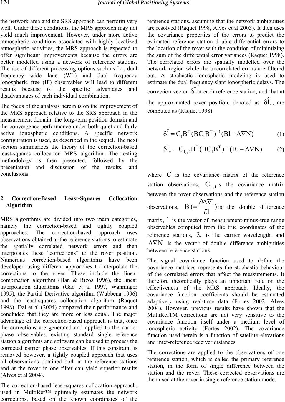 174 Journal of Global Positioning Systems the network area and the SRS approach can perform very well. Under these conditions, the MRS approach may not yield much improvement. However, under more active atmospheric conditions associated with highly localized atmospheric activities, the MRS approach is expected to offer significant improvements because the errors are better modelled using a network of reference stations. The use of different processing options such as L1, dual frequency wide lane (WL) and dual frequency ionospheric free (IF) observables will lead to different results because of the specific advantages and disadvantages of each individual combination. The focus of the analysis herein is on the improvement of the MRS approach relative to the SRS approach in the measurement domain, the long-term position domain and the convergence performance under both quiet and fairly active ionospheric conditions. A specific network configuration is used, as described in the sequel. The next section summarizes the theory of the correction-based least-squares collocation MRS algorithm. The testing methodology is then presented, followed by the presentation and discussion of the results, and conclusions. 2 Correction-Based Least-Squares Collocation Algorithm MRS algorithms are divided into two main categories, namely the correction-based and tightly coupled approaches. The correction-based approach uses observations obtained at the reference stations to estimate the spatially correlated network errors and then interpolates these “corrections” to the rover position. Numerous correction-based algorithms have been developed using different approaches to interpolate the corrections to the rover. These include the linear combination algorithm (Han & Rizos 1996), the linear interpolation algorithms (Gao et al 1997, Wanninger 1995), the Partial Derivative algorithm (Wübbena 1996) and the least-squares collocation algorithm (Raquet 1998). Dai et al (2004) compared their performance and concluded that they are more or less equal. The major advantage of the correction-based approach is that, once the corrections are generated and applied to the carrier phase observables, existing standard single reference station algorithms and software can be used to process the corrected carrier phase observables. If this constraint is removed however, a tightly coupled approach that uses all observations obtained both at the reference stations and at the rover in one filter can yield superior results (Alves et al 2004). The correction-based least-squares collocation approach, used in MultiRef™ optimally estimates the network corrections, based on the known coordinates of the reference stations, assuming that the network ambiguities are resolved (Raquet 1998, Alves et al 2003). It then uses the covariance properties of the errors to predict the estimated reference station double differential errors to the location of the rover with the condition of minimizing the sum of the differential error variances (Raquet 1998). The correlated errors are spatially modelled over the network region while the uncorrelated errors are filtered out. A stochastic ionospheric modeling is used to estimate the dual frequency slant ionospheric delays. The correction vector l ˆ δat each reference station, and that at the approximated rover position, denoted as r l ˆ δ, are computed as (Raquet 1998) )NBl()BBC(BCl ˆ1T l T l∇∆−=δ − (1) )NBl()BBC(BCl ˆ1T l T l,lr r ∇∆−=δ − (2) where l C is the covariance matrix of the reference station observations, l,lr Cis the covariance matrix between the rover observations and the reference station observations, ) l l (B ∂ ∇ ∆ ∂ =is the double difference matrix, l is the vector of measurement-minus-true range observables computed from the true coordinates of the reference stations, λ is the carrier wavelength, and N ∇ ∆ is the vector of double difference ambiguities between reference stations. The signal covariance function used to define the covariance matrices represents the stochastic behaviour of the correlated errors that affect the measurements. It therefore theoretically plays an important role on the effectiveness of the MRS approach. Ideally, the covariance function coefficients should be estimated adaptively using real-time data (Fortes 2002, Alves 2004). However, previous results have shown that the MultiRefTM corrections are not very sensitive to the covariance function itself under a medium level of ionospheric activity (Fortes 2002). The covariance function used herein is a function of satellite elevations and inter-reference receiver distances. The corrections are applied to the observations of one reference station, which is called the primary reference station, in the form of single difference between the station and the rover. These corrected observations are then used at the rover in single reference station mode. 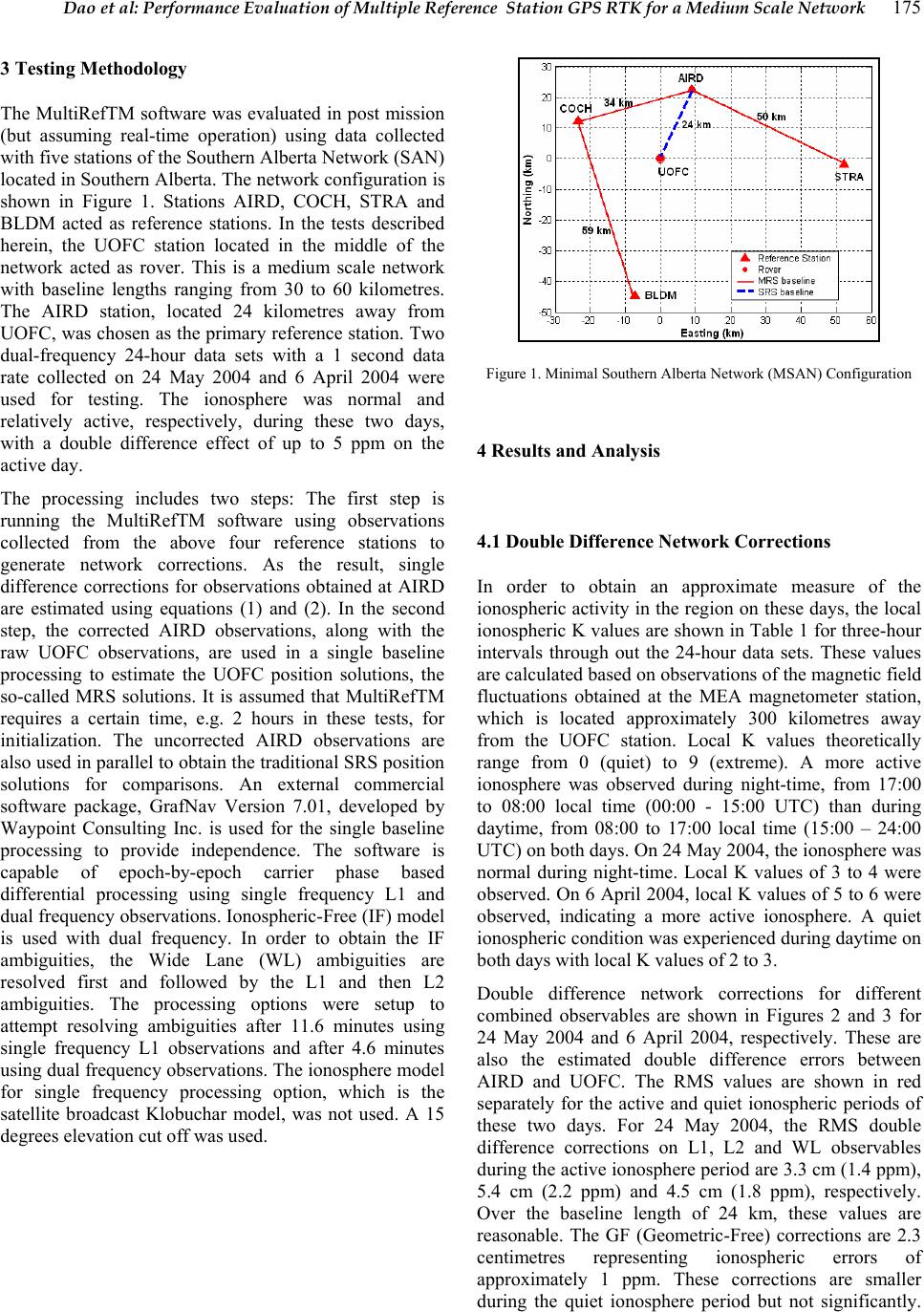 Dao et al: Performance Evaluation of Multiple Reference Station GPS RTK for a Medium Scale Network 175 3 Testing Methodology The MultiRefTM software was evaluated in post mission (but assuming real-time operation) using data collected with five stations of the Southern Alberta Network (SAN) located in Southern Alberta. The network configuration is shown in Figure 1. Stations AIRD, COCH, STRA and BLDM acted as reference stations. In the tests described herein, the UOFC station located in the middle of the network acted as rover. This is a medium scale network with baseline lengths ranging from 30 to 60 kilometres. The AIRD station, located 24 kilometres away from UOFC, was chosen as the primary reference station. Two dual-frequency 24-hour data sets with a 1 second data rate collected on 24 May 2004 and 6 April 2004 were used for testing. The ionosphere was normal and relatively active, respectively, during these two days, with a double difference effect of up to 5 ppm on the active day. The processing includes two steps: The first step is running the MultiRefTM software using observations collected from the above four reference stations to generate network corrections. As the result, single difference corrections for observations obtained at AIRD are estimated using equations (1) and (2). In the second step, the corrected AIRD observations, along with the raw UOFC observations, are used in a single baseline processing to estimate the UOFC position solutions, the so-called MRS solutions. It is assumed that MultiRefTM requires a certain time, e.g. 2 hours in these tests, for initialization. The uncorrected AIRD observations are also used in parallel to obtain the traditional SRS position solutions for comparisons. An external commercial software package, GrafNav Version 7.01, developed by Waypoint Consulting Inc. is used for the single baseline processing to provide independence. The software is capable of epoch-by-epoch carrier phase based differential processing using single frequency L1 and dual frequency observations. Ionospheric-Free (IF) model is used with dual frequency. In order to obtain the IF ambiguities, the Wide Lane (WL) ambiguities are resolved first and followed by the L1 and then L2 ambiguities. The processing options were setup to attempt resolving ambiguities after 11.6 minutes using single frequency L1 observations and after 4.6 minutes using dual frequency observations. The ionosphere model for single frequency processing option, which is the satellite broadcast Klobuchar model, was not used. A 15 degrees elevation cut off was used. Figure 1. Minimal Southern Alberta Network (MSAN) Configuration 4 Results and Analysis 4.1 Double Difference Network Corrections In order to obtain an approximate measure of the ionospheric activity in the region on these days, the local ionospheric K values are shown in Table 1 for three-hour intervals through out the 24-hour data sets. These values are calculated based on observations of the magnetic field fluctuations obtained at the MEA magnetometer station, which is located approximately 300 kilometres away from the UOFC station. Local K values theoretically range from 0 (quiet) to 9 (extreme). A more active ionosphere was observed during night-time, from 17:00 to 08:00 local time (00:00 - 15:00 UTC) than during daytime, from 08:00 to 17:00 local time (15:00 – 24:00 UTC) on both days. On 24 May 2004, the ionosphere was normal during night-time. Local K values of 3 to 4 were observed. On 6 April 2004, local K values of 5 to 6 were observed, indicating a more active ionosphere. A quiet ionospheric condition was experienced during daytime on both days with local K values of 2 to 3. Double difference network corrections for different combined observables are shown in Figures 2 and 3 for 24 May 2004 and 6 April 2004, respectively. These are also the estimated double difference errors between AIRD and UOFC. The RMS values are shown in red separately for the active and quiet ionospheric periods of these two days. For 24 May 2004, the RMS double difference corrections on L1, L2 and WL observables during the active ionosphere period are 3.3 cm (1.4 ppm), 5.4 cm (2.2 ppm) and 4.5 cm (1.8 ppm), respectively. Over the baseline length of 24 km, these values are reasonable. The GF (Geometric-Free) corrections are 2.3 centimetres representing ionospheric errors of approximately 1 ppm. These corrections are smaller during the quiet ionosphere period but not significantly.  176 Journal of Global Positioning Systems The IF (Ionospheric-Free) corrections are small and constant throughout the day, with a magnitude of 1 cm. These corrections are mainly due to the tropospheric residuals and noise. Table 1: The local K values obtained at MEA geomagnetic station located in Edmonton (approximately 300 km away from UOFC station) Hour of day (UTC time) 0 - 3 3 - 6 6 - 9 9 - 12 12 - 15 15 - 18 18 - 21 21 - 24 May 24, 2004 3 1 4 3 4 2 2 2 April 6, 2004 6 4 5 5 5 2 2 3 The network corrections are larger on 6 April 2004. This is expected due to the more active ionosphere as discussed. The estimated RMS value, for all errors on L1 observations, is 9.8 cm or 4 ppm over the 24 km baseline. The GF corrections are 6.6 cm, equivalent to 3 ppm over 24 km baseline. These are mainly caused by the ionosphere, which is fairly active. During daytime (quiet ionosphere), the corrections are again smaller than the ones obtained during night-time (more active ionosphere) but are larger than the ones obtained during daytime on 24 May 2004. The correction variation correlates well with the variation in the local K indices. The IF corrections, with a magnitude of approximately 1.1 cm for the entire day, show that the tropospheric residuals were consistent. Figure 2. Double difference network corrections for all satellites pairs for 24 May 2004 Figure 3. Double difference network corrections for all satellites pairs for 6 April 2004 The network ambiguities were resolved approximately 90 % of the time on both days. This suggests that the ionospheric model was effective in estimating the double difference slant ionospheric effects even under fairly active conditions. The network corrections can be considered reliable with such high percentage of fixed ambiguities. 4.2 MRS Improvement in Observation Domain Figures 4 and 5 show the AIRD-UOCF double difference observable misclosures for 24 May 2004 and 6 April 2004, respectively. Both AIRD station and UOFC station were fixed to their true coordinates for this analysis. The misclosures calculated using the raw uncorrected AIRD observations (SRS) are shown in red while the ones using the corrected AIRD observations (MRS) are shown in blue. A table at the bottom of each figure gives a summary of the statistics. The misclosures are generally larger for 4 April 2004. This is due to the higher ionospheric error experienced on that day. The MRS approach yields improvement relative to SRS approach with the use of L1, L2, WL and GF observables for both data sets. Higher level of improvement is observed under higher ionospheric condition. For example, MRS approach reduced the RMS of the misclosures by 45 % for 6 April (high ionosphere) compared to 35 % for 24 May 2004 (normal ionosphere). However, MRS does not yield any improvement for IF observables under either condition. This is because the largest error, ionosphere, is eliminated in this case while the double difference troposphere residuals and satellite orbit error are small over the distance of 24 km. 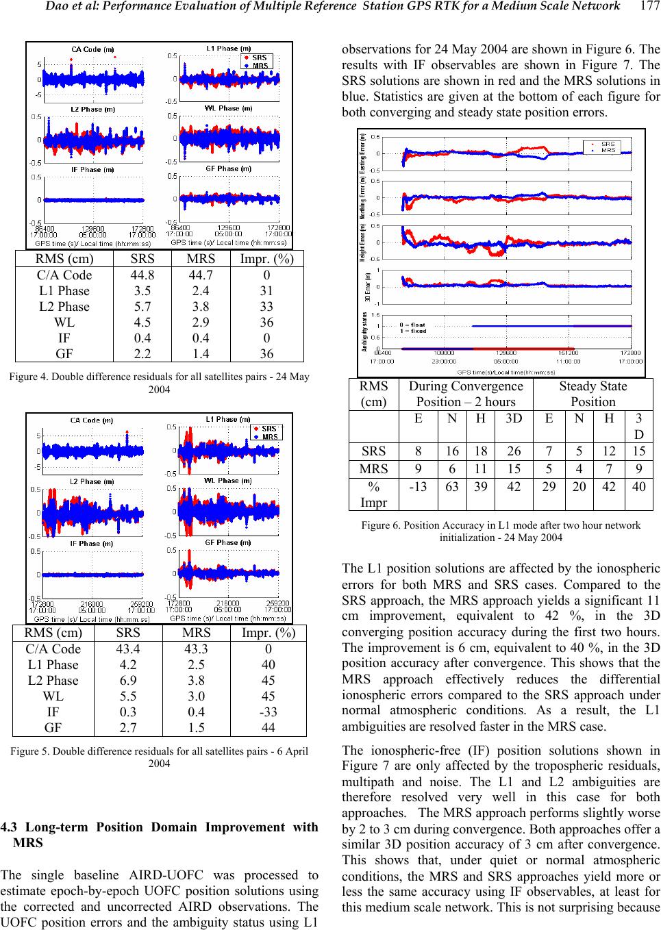 Dao et al: Performance Evaluation of Multiple Reference Station GPS RTK for a Medium Scale Network 177 RMS (cm) SRS MRS Impr. (%) C/A Code L1 Phase L2 Phase WL IF GF 44.8 3.5 5.7 4.5 0.4 2.2 44.7 2.4 3.8 2.9 0.4 1.4 0 31 33 36 0 36 Figure 4. Double difference residuals for all satellites pairs - 24 May 2004 RMS (cm) SRS MRS Impr. (%) C/A Code L1 Phase L2 Phase WL IF GF 43.4 4.2 6.9 5.5 0.3 2.7 43.3 2.5 3.8 3.0 0.4 1.5 0 40 45 45 -33 44 Figure 5. Double difference residuals for all satellites pairs - 6 April 2004 4.3 Long-term Position Domain Improvement with MRS The single baseline AIRD-UOFC was processed to estimate epoch-by-epoch UOFC position solutions using the corrected and uncorrected AIRD observations. The UOFC position errors and the ambiguity status using L1 observations for 24 May 2004 are shown in Figure 6. The results with IF observables are shown in Figure 7. The SRS solutions are shown in red and the MRS solutions in blue. Statistics are given at the bottom of each figure for both converging and steady state position errors. RMS (cm) During Convergence Position – 2 hours Steady State Position E N H 3D E N H 3 D SRS 8 16 18 26 7 5 12 15 MRS 9 6 11 15 5 4 7 9 % Impr -13 63 39 42 29 20 42 40 Figure 6. Position Accuracy in L1 mode after two hour network initialization - 24 May 2004 The L1 position solutions are affected by the ionospheric errors for both MRS and SRS cases. Compared to the SRS approach, the MRS approach yields a significant 11 cm improvement, equivalent to 42 %, in the 3D converging position accuracy during the first two hours. The improvement is 6 cm, equivalent to 40 %, in the 3D position accuracy after convergence. This shows that the MRS approach effectively reduces the differential ionospheric errors compared to the SRS approach under normal atmospheric conditions. As a result, the L1 ambiguities are resolved faster in the MRS case. The ionospheric-free (IF) position solutions shown in Figure 7 are only affected by the tropospheric residuals, multipath and noise. The L1 and L2 ambiguities are therefore resolved very well in this case for both approaches. The MRS approach performs slightly worse by 2 to 3 cm during convergence. Both approaches offer a similar 3D position accuracy of 3 cm after convergence. This shows that, under quiet or normal atmospheric conditions, the MRS and SRS approaches yield more or less the same accuracy using IF observables, at least for this medium scale network. This is not surprising because 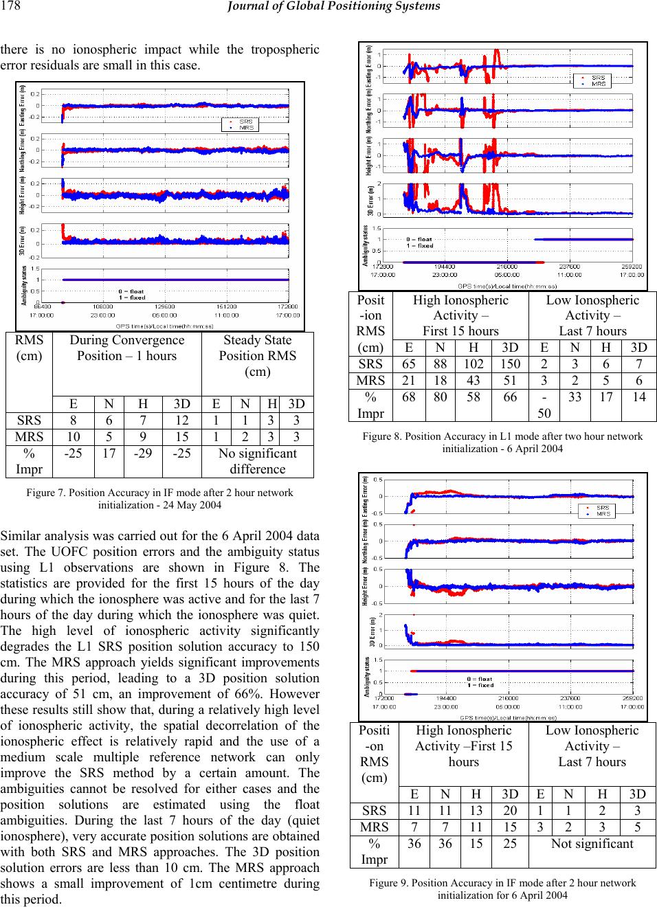 178 Journal of Global Positioning Systems there is no ionospheric impact while the tropospheric error residuals are small in this case. During Convergence Position – 1 hours Steady State Position RMS (cm) RMS (cm) E N H 3D E N H3D SRS 8 6 7 12 1 1 33 MRS 10 5 9 15 1 2 33 % Impr -25 17 -29 -25 No significant difference Figure 7. Position Accuracy in IF mode after 2 hour network initialization - 24 May 2004 Similar analysis was carried out for the 6 April 2004 data set. The UOFC position errors and the ambiguity status using L1 observations are shown in Figure 8. The statistics are provided for the first 15 hours of the day during which the ionosphere was active and for the last 7 hours of the day during which the ionosphere was quiet. The high level of ionospheric activity significantly degrades the L1 SRS position solution accuracy to 150 cm. The MRS approach yields significant improvements during this period, leading to a 3D position solution accuracy of 51 cm, an improvement of 66%. However these results still show that, during a relatively high level of ionospheric activity, the spatial decorrelation of the ionospheric effect is relatively rapid and the use of a medium scale multiple reference network can only improve the SRS method by a certain amount. The ambiguities cannot be resolved for either cases and the position solutions are estimated using the float ambiguities. During the last 7 hours of the day (quiet ionosphere), very accurate position solutions are obtained with both SRS and MRS approaches. The 3D position solution errors are less than 10 cm. The MRS approach shows a small improvement of 1cm centimetre during this period. High Ionospheric Activity – First 15 hours Low Ionospheric Activity – Last 7 hours Posit -ion RMS (cm) E N H 3D E N H 3D SRS 65 88 102 150 2 3 6 7 MRS 21 18 43 51 3 2 5 6 % Impr 68 80 58 66 - 50 33 17 14 Figure 8. Position Accuracy in L1 mode after two hour network initialization - 6 April 2004 High Ionospheric Activity –First 15 hours Low Ionospheric Activity – Last 7 hours Positi -on RMS (cm) E N H 3D E N H 3D SRS 11 11 13 20 1 1 2 3 MRS 7 7 11 15 3 2 3 5 % Impr 36 36 15 25 Not significant Figure 9. Position Accuracy in IF mode after 2 hour network initialization for 6 April 2004 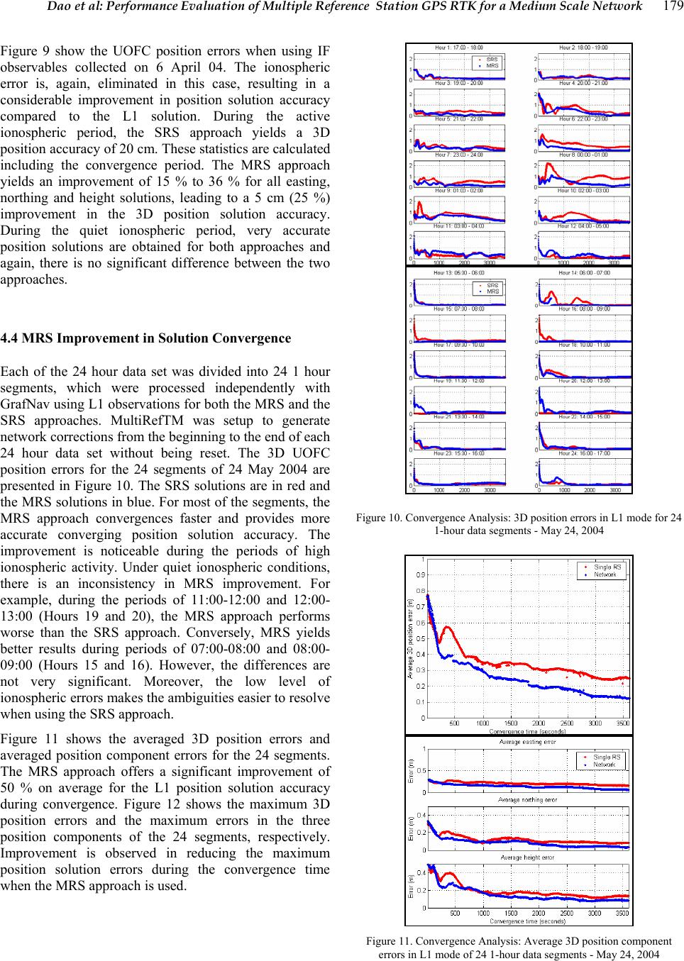 Dao et al: Performance Evaluation of Multiple Reference Station GPS RTK for a Medium Scale Network 179 Figure 9 show the UOFC position errors when using IF observables collected on 6 April 04. The ionospheric error is, again, eliminated in this case, resulting in a considerable improvement in position solution accuracy compared to the L1 solution. During the active ionospheric period, the SRS approach yields a 3D position accuracy of 20 cm. These statistics are calculated including the convergence period. The MRS approach yields an improvement of 15 % to 36 % for all easting, northing and height solutions, leading to a 5 cm (25 %) improvement in the 3D position solution accuracy. During the quiet ionospheric period, very accurate position solutions are obtained for both approaches and again, there is no significant difference between the two approaches. 4.4 MRS Improvement in Solution Convergence Each of the 24 hour data set was divided into 24 1 hour segments, which were processed independently with GrafNav using L1 observations for both the MRS and the SRS approaches. MultiRefTM was setup to generate network corrections from the beginning to the end of each 24 hour data set without being reset. The 3D UOFC position errors for the 24 segments of 24 May 2004 are presented in Figure 10. The SRS solutions are in red and the MRS solutions in blue. For most of the segments, the MRS approach convergences faster and provides more accurate converging position solution accuracy. The improvement is noticeable during the periods of high ionospheric activity. Under quiet ionospheric conditions, there is an inconsistency in MRS improvement. For example, during the periods of 11:00-12:00 and 12:00- 13:00 (Hours 19 and 20), the MRS approach performs worse than the SRS approach. Conversely, MRS yields better results during periods of 07:00-08:00 and 08:00- 09:00 (Hours 15 and 16). However, the differences are not very significant. Moreover, the low level of ionospheric errors makes the ambiguities easier to resolve when using the SRS approach. Figure 11 shows the averaged 3D position errors and averaged position component errors for the 24 segments. The MRS approach offers a significant improvement of 50 % on average for the L1 position solution accuracy during convergence. Figure 12 shows the maximum 3D position errors and the maximum errors in the three position components of the 24 segments, respectively. Improvement is observed in reducing the maximum position solution errors during the convergence time when the MRS approach is used. Figure 10. Convergence Analysis: 3D position errors in L1 mode for 24 1-hour data segments - May 24, 2004 Figure 11. Convergence Analysis: Average 3D position component errors in L1 mode of 24 1-hour data segments - May 24, 2004 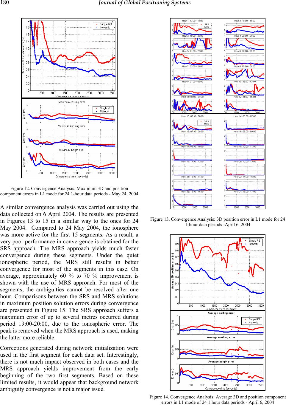 180 Journal of Global Positioning Systems Figure 12. Convergence Analysis: Maximum 3D and position component errors in L1 mode for 24 1-hour data periods - May 24, 2004 A similar convergence analysis was carried out using the data collected on 6 April 2004. The results are presented in Figures 13 to 15 in a similar way to the ones for 24 May 2004. Compared to 24 May 2004, the ionosphere was more active for the first 15 segments. As a result, a very poor performance in convergence is obtained for the SRS approach. The MRS approach yields much faster convergence during these segments. Under the quiet ionospheric period, the MRS still results in better convergence for most of the segments in this case. On average, approximately 60 % to 70 % improvement is shown with the use of MRS approach. For most of the segments, the ambiguities cannot be resolved after one hour. Comparisons between the SRS and MRS solutions in maximum position solution errors during convergence are presented in Figure 15. The SRS approach suffers a maximum error of up to several metres occurred during period 19:00-20:00, due to the ionospheric error. The peak is removed when the MRS approach is used, making the latter more reliable. Corrections generated during network initialization were used in the first segment for each data set. Interestingly, there is not much impact observed in both cases and the MRS approach yields improvement from the early beginning of the two first segments. Based on these limited results, it would appear that background network ambiguity convergence is not a major issue. Figure 13. Convergence Analysis: 3D position error in L1 mode for 24 1-hour data periods -April 6, 2004 Figure 14. Convergence Analysis: Average 3D and position component errors in L1 mode of 24 1 hour data periods - April 6, 2004 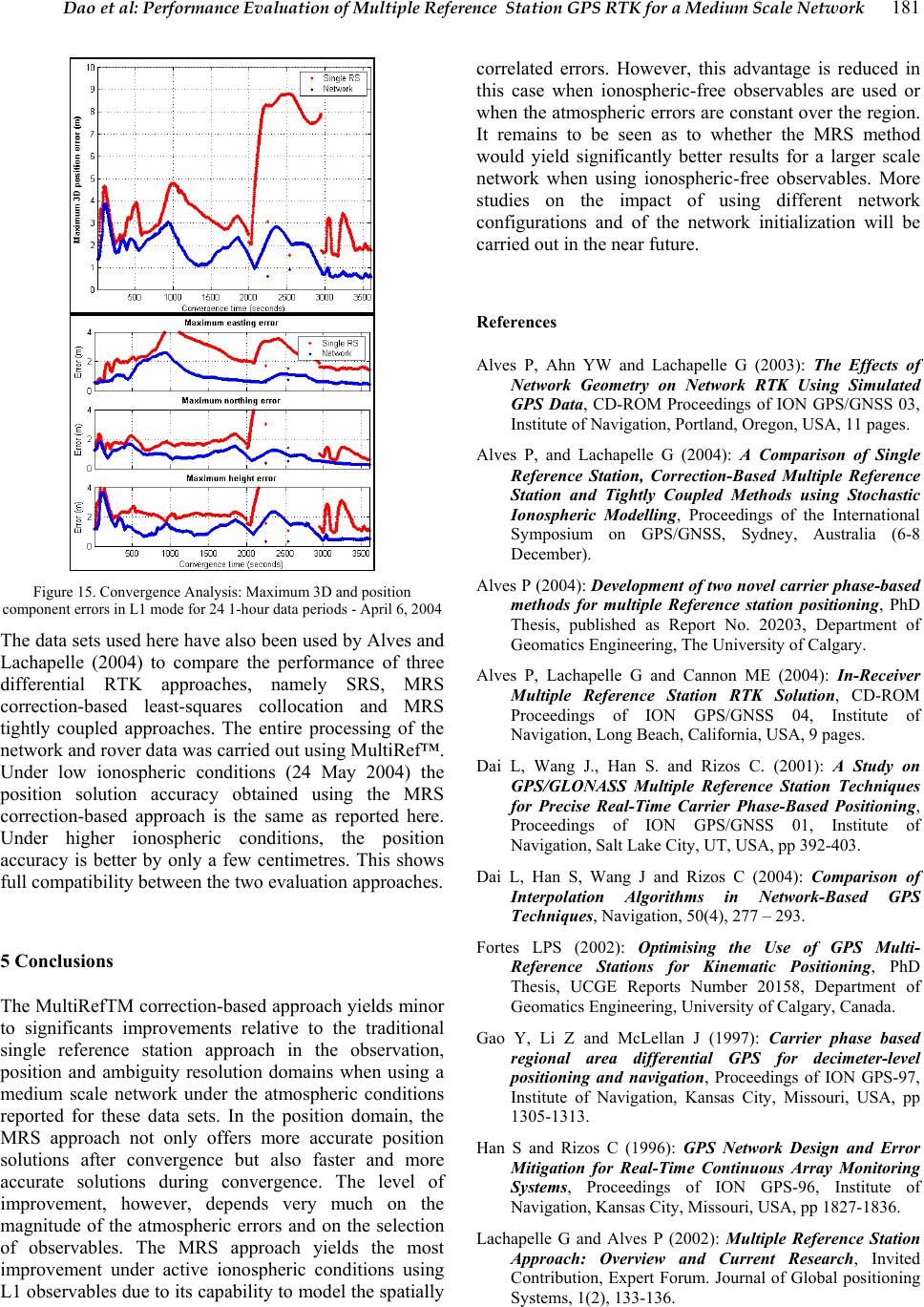 Dao et al: Performance Evaluation of Multiple Reference Station GPS RTK for a Medium Scale Network 181 Figure 15. Convergence Analysis: Maximum 3D and position component errors in L1 mode for 24 1-hour data periods - April 6, 2004 The data sets used here have also been used by Alves and Lachapelle (2004) to compare the performance of three differential RTK approaches, namely SRS, MRS correction-based least-squares collocation and MRS tightly coupled approaches. The entire processing of the network and rover data was carried out using MultiRef™. Under low ionospheric conditions (24 May 2004) the position solution accuracy obtained using the MRS correction-based approach is the same as reported here. Under higher ionospheric conditions, the position accuracy is better by only a few centimetres. This shows full compatibility between the two evaluation approaches. 5 Conclusions The MultiRefTM correction-based approach yields minor to significants improvements relative to the traditional single reference station approach in the observation, position and ambiguity resolution domains when using a medium scale network under the atmospheric conditions reported for these data sets. In the position domain, the MRS approach not only offers more accurate position solutions after convergence but also faster and more accurate solutions during convergence. The level of improvement, however, depends very much on the magnitude of the atmospheric errors and on the selection of observables. The MRS approach yields the most improvement under active ionospheric conditions using L1 observables due to its capability to model the spatially correlated errors. However, this advantage is reduced in this case when ionospheric-free observables are used or when the atmospheric errors are constant over the region. It remains to be seen as to whether the MRS method would yield significantly better results for a larger scale network when using ionospheric-free observables. More studies on the impact of using different network configurations and of the network initialization will be carried out in the near future. References Alves P, Ahn YW and Lachapelle G (2003): The Effects of Network Geometry on Network RTK Using Simulated GPS Data, CD-ROM Proceedings of ION GPS/GNSS 03, Institute of Navigation, Portland, Oregon, USA, 11 pages. Alves P, and Lachapelle G (2004): A Comparison of Single Reference Station, Correction-Based Multiple Reference Station and Tightly Coupled Methods using Stochastic Ionospheric Modelling, Proceedings of the International Symposium on GPS/GNSS, Sydney, Australia (6-8 December). Alves P (2004): Development of two novel carrier phase-based methods for multiple Reference station positioning, PhD Thesis, published as Report No. 20203, Department of Geomatics Engineering, The University of Calgary. Alves P, Lachapelle G and Cannon ME (2004): In-Receiver Multiple Reference Station RTK Solution, CD-ROM Proceedings of ION GPS/GNSS 04, Institute of Navigation, Long Beach, California, USA, 9 pages. Dai L, Wang J., Han S. and Rizos C. (2001): A Study on GPS/GLONASS Multiple Reference Station Techniques for Precise Real-Time Carrier Phase-Based Positioning, Proceedings of ION GPS/GNSS 01, Institute of Navigation, Salt Lake City, UT, USA, pp 392-403. Dai L, Han S, Wang J and Rizos C (2004): Comparison of Interpolation Algorithms in Network-Based GPS Techniques, Navigation, 50(4), 277 – 293. Fortes LPS (2002): Optimising the Use of GPS Multi- Reference Stations for Kinematic Positioning, PhD Thesis, UCGE Reports Number 20158, Department of Geomatics Engineering, University of Calgary, Canada. Gao Y, Li Z and McLellan J (1997): Carrier phase based regional area differential GPS for decimeter-level positioning and navigation, Proceedings of ION GPS-97, Institute of Navigation, Kansas City, Missouri, USA, pp 1305-1313. Han S and Rizos C (1996): GPS Network Design and Error Mitigation for Real-Time Continuous Array Monitoring Systems, Proceedings of ION GPS-96, Institute of Navigation, Kansas City, Missouri, USA, pp 1827-1836. Lachapelle G and Alves P (2002): Multiple Reference Station Approach: Overview and Current Research, Invited Contribution, Expert Forum. Journal of Global positioning Systems, 1(2), 133-136.  182 Journal of Global Positioning Systems Raquet J (1998: Development of a Method for Kinematic GPS Carrier-Phase Ambiguity Resolution Using Multiple Reference Receivers, PhD Thesis, UCGE Report Number 20116, Department of Geomatics Engineering, University of Calgary, Canada. Waypoint Consulting Inc. (2004): GrafNav/GrafNet, GrafNav Lite, GrafMov, Inertial Explorer for Window 95TM, 98TM, 2000TM, XPTM & NTTM Operating Manual,Version 7.0. Canada Wanninger L (1995): Improved Ambiguity Resolution by Regional Di®erential Modeling of the Ionosphere, Proceedings of ION GPS-95, Institute of Navigation, Palm Springs, CA, USA, pp 55-62. Wübbena C, Bagge A, Seeber G, Volker B, and Hankemmeier P, (1996): Reducing Distance Dependent Errors for Real -time Precise DGPS Applications by Establishing Reference Station Netwroks, Proceedings of ION GPS-96, Institute of Navigation, Kansas City, Missouri, USA, pp 1845-1852. |