Paper Menu >>
Journal Menu >>
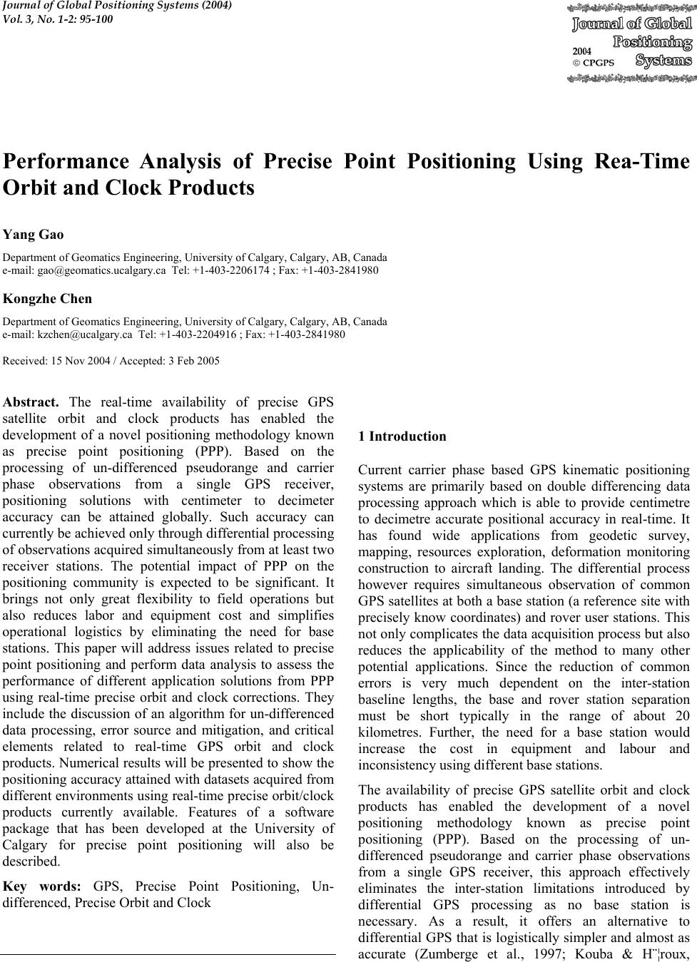 Journal of Global Positioning Systems (2004) Vol. 3, No. 1-2: 95-100 Performance Analysis of Precise Point Positioning Using Rea-Time Orbit and Clock Products Yang Gao Department of Geomatics Engineering, University of Calgary, Calgary, AB, Canada e-mail: gao@geomatics.ucalgary.ca Tel: +1-403-2206174 ; Fax: +1-403-2841980 Kongzhe Chen Department of Geomatics Engineering, University of Calgary, Calgary, AB, Canada e-mail: kzchen@ucalgary.ca Tel: +1-403-2204916 ; Fax: +1-403-2841980 Received: 15 Nov 2004 / Accepted: 3 Feb 2005 Abstract. The real-time availability of precise GPS satellite orbit and clock products has enabled the development of a novel positioning methodology known as precise point positioning (PPP). Based on the processing of un-differenced pseudorange and carrier phase observations from a single GPS receiver, positioning solutions with centimeter to decimeter accuracy can be attained globally. Such accuracy can currently be achieved only through differential processing of observations acquired simultaneously from at least two receiver stations. The potential impact of PPP on the positioning community is expected to be significant. It brings not only great flexibility to field operations but also reduces labor and equipment cost and simplifies operational logistics by eliminating the need for base stations. This paper will address issues related to precise point positioning and perform data analysis to assess the performance of different application solutions from PPP using real-time precise orbit and clock corrections. They include the discussion of an algorithm for un-differenced data processing, error source and mitigation, and critical elements related to real-time GPS orbit and clock products. Numerical results will be presented to show the positioning accuracy attained with datasets acquired from different environments using real-time precise orbit/clock products currently available. Features of a software package that has been developed at the University of Calgary for precise point positioning will also be described. Key words: GPS, Precise Point Positioning, Un- differenced, Precise Orbit and Clock 1 Introduction Current carrier phase based GPS kinematic positioning systems are primarily based on double differencing data processing approach which is able to provide centimetre to decimetre accurate positional accuracy in real-time. It has found wide applications from geodetic survey, mapping, resources exploration, deformation monitoring construction to aircraft landing. The differential process however requires simultaneous observation of common GPS satellites at both a base station (a reference site with precisely know coordinates) and rover user stations. This not only complicates the data acquisition process but also reduces the applicability of the method to many other potential applications. Since the reduction of common errors is very much dependent on the inter-station baseline lengths, the base and rover station separation must be short typically in the range of about 20 kilometres. Further, the need for a base station would increase the cost in equipment and labour and inconsistency using different base stations. The availability of precise GPS satellite orbit and clock products has enabled the development of a novel positioning methodology known as precise point positioning (PPP). Based on the processing of un- differenced pseudorange and carrier phase observations from a single GPS receiver, this approach effectively eliminates the inter-station limitations introduced by differential GPS processing as no base station is necessary. As a result, it offers an alternative to differential GPS that is logistically simpler and almost as accurate (Zumberge et al., 1997; Kouba & H¨¦roux, 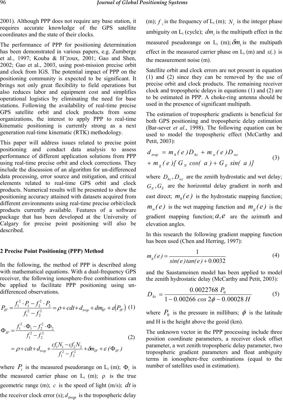 96 Journal of Global Positioning Systems 2001). Although PPP does not require any base station, it requires accurate knowledge of the GPS satellite coordinates and the state of their clocks. The performance of PPP for positioning determination has been demonstrated in various papers, e.g. Zumberge et al., 1997; Kouba & H¨¦roux, 2001; Gao and Shen, 2002; Gao et al., 2003, using post-mission precise orbit and clock from IGS. The potential impact of PPP on the positioning community is expected to be significant. It brings not only great flexibility to field operations but also reduces labor and equipment cost and simplifies operational logistics by eliminating the need for base stations. Following the availability of real-time precise GPS satellite orbit and clock products from some organizations, the interest to apply PPP to real-time kinematic positioning is currently strong as a next generation real-time kinematic (RTK) methodology. This paper will address issues related to precise point positioning and conduct data analysis to assess performance of different application solutions from PPP using real-time precise orbit and clock corrections. They include the discussion of an algorithm for un-differenced data processing, error source and mitigation, and critical elements related to real-time GPS orbit and clock products. Numerical results will be presented to show the positioning accuracy attained with datasets acquired from different environments using real-time precise orbit/clock products currently available. Features of a software package that has been developed at the University of Calgary for precise point positioning will also be described. 2 Precise Point Positioning (PPP) Method In the following, the method of PPP is described along with mathematical equations. With a dual-frequency GPS receiver, the following ionosphere-free combinations can be applied to facilitate PPP positioning using un- differenced observations. () IFIFtropIF Pdmdcdt ff PfPf P ερ ++++= − ⋅−⋅ =2 2 2 1 2 2 21 2 1 (1) )( m ff NcfNcf dcdt ff ff IFIFtrop IF Φ++ − − +++= − Φ⋅−Φ⋅ =Φ εδρ 2 2 2 1 2211 2 2 2 1 2 2 21 2 1 (2) where i P is the measured pseudorange on Li (m); i Φ is the measured carrier phase on Li (m); ρ is the true geometric range (m); c is the speed of light (m/s); dt is the receiver clock error (s);trop d is the tropospheric delay (m); i fis the frequency of Li (m); i N is the integer phase ambiguity on Li (cycle); i dm is the multipath effect in the measured pseudorange on Li (m);i m δ is the multipath effect in the measured carrier phase on Li (m) and (.) ε is the measurement noise (m). Satellite orbit and clock errors are not present in equation (1) and (2) since they can be removed by the use of precise orbit and clock products. The remaining receiver clock and tropospheric delays in equations (1) and (2) are to be estimated in PPP. A choke-ring antenna should be used in the presence of significant multipath. The estimation of tropospheric gradients is beneficial for both GPS positioning and tropospheric delay estimation (Bar-sever et al., 1998). The following equation can be used to model the tropospheric effect (McCarthy and Petit, 2003): )]asin(G)acos(G)[e(m D)e(mD)e(md ENg wzwhzhtrop ++ + = (3) where hz D,wz D are the zenith hydrostatic and wet delay; N G,E G are the horizontal delay gradient in north and east direct; )e(mh is the hydrostatic mapping function; )e(mw is the wet mapping function and )e(mg is the gradient mapping function;e , a are the azimuth and elevation angles. In this research the following gradient mapping function has been used (Chen and Herring, 1997): 00320 1 .)etan()esin( )e(mg+ = (4) and the Saastamoinen model has been applied to model the zenith hydrostatic delay (McCarthy and Petit, 2003): H.cos. P. Dhz 00028020026601 00227680 0 −− = φ (5) where 0 P is the pressure in millibars; φ is the latitude and H is the height above the geoid (km). The unknown vector in the PPP processing include three position coordinate parameters, a receiver clock offset parameter, a wet zenith tropospheric delay parameter, two tropospheric gradient parameters and float ambiguity terms in ionosphere-free combinations (equal to the number of satellites used in estimation). 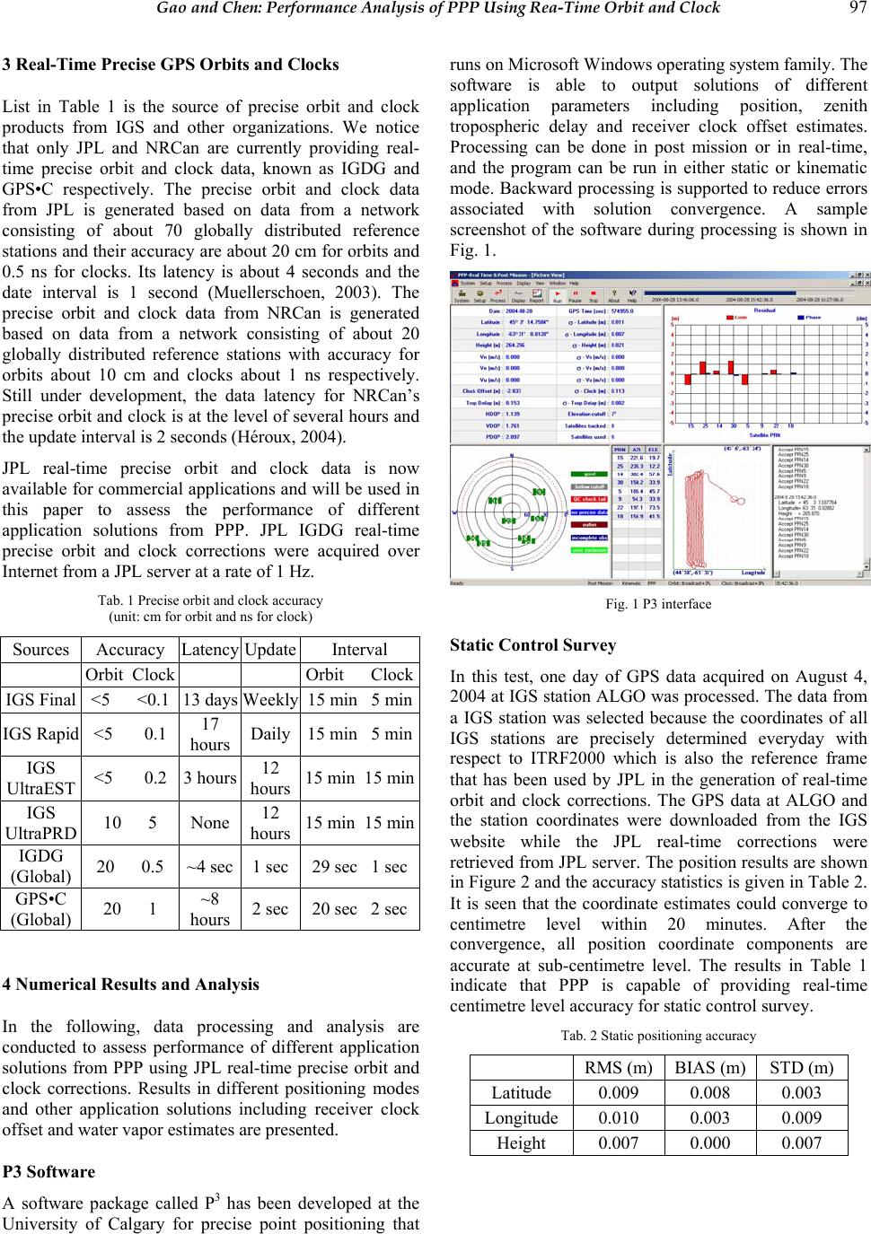 Gao and Chen: Performance Analysis of PPP Using Rea-Time Orbit and Clock 97 3 Real-Time Precise GPS Orbits and Clocks List in Table 1 is the source of precise orbit and clock products from IGS and other organizations. We notice that only JPL and NRCan are currently providing real- time precise orbit and clock data, known as IGDG and GPS•C respectively. The precise orbit and clock data from JPL is generated based on data from a network consisting of about 70 globally distributed reference stations and their accuracy are about 20 cm for orbits and 0.5 ns for clocks. Its latency is about 4 seconds and the date interval is 1 second (Muellerschoen, 2003). The precise orbit and clock data from NRCan is generated based on data from a network consisting of about 20 globally distributed reference stations with accuracy for orbits about 10 cm and clocks about 1 ns respectively. Still under development, the data latency for NRCan’s precise orbit and clock is at the level of several hours and the update interval is 2 seconds (Héroux, 2004). JPL real-time precise orbit and clock data is now available for commercial applications and will be used in this paper to assess the performance of different application solutions from PPP. JPL IGDG real-time precise orbit and clock corrections were acquired over Internet from a JPL server at a rate of 1 Hz. Tab. 1 Precise orbit and clock accuracy (unit: cm for orbit and ns for clock) Sources Accuracy Latency Update Interval Orbit Clock Orbit Clock IGS Final <5 <0.1 13 days Weekly 15 min 5 min IGS Rapid <5 0.1 17 hours Daily 15 min 5 min IGS UltraEST <5 0.2 3 hours 12 hours 15 min 15 min IGS UltraPRD 10 5 None 12 hours 15 min 15 min IGDG (Global) 20 0.5 ~4 sec 1 sec 29 sec 1 sec GPS•C (Global) 20 1 ~8 hours 2 sec 20 sec 2 sec 4 Numerical Results and Analysis In the following, data processing and analysis are conducted to assess performance of different application solutions from PPP using JPL real-time precise orbit and clock corrections. Results in different positioning modes and other application solutions including receiver clock offset and water vapor estimates are presented. P3 Software A software package called P3 has been developed at the University of Calgary for precise point positioning that runs on Microsoft Windows operating system family. The software is able to output solutions of different application parameters including position, zenith tropospheric delay and receiver clock offset estimates. Processing can be done in post mission or in real-time, and the program can be run in either static or kinematic mode. Backward processing is supported to reduce errors associated with solution convergence. A sample screenshot of the software during processing is shown in Fig. 1. Fig. 1 P3 interface Static Control Survey In this test, one day of GPS data acquired on August 4, 2004 at IGS station ALGO was processed. The data from a IGS station was selected because the coordinates of all IGS stations are precisely determined everyday with respect to ITRF2000 which is also the reference frame that has been used by JPL in the generation of real-time orbit and clock corrections. The GPS data at ALGO and the station coordinates were downloaded from the IGS website while the JPL real-time corrections were retrieved from JPL server. The position results are shown in Figure 2 and the accuracy statistics is given in Table 2. It is seen that the coordinate estimates could converge to centimetre level within 20 minutes. After the convergence, all position coordinate components are accurate at sub-centimetre level. The results in Table 1 indicate that PPP is capable of providing real-time centimetre level accuracy for static control survey. Tab. 2 Static positioning accuracy RMS (m) BIAS (m) STD (m) Latitude 0.009 0.008 0.003 Longitude 0.010 0.003 0.009 Height 0.007 0.000 0.007 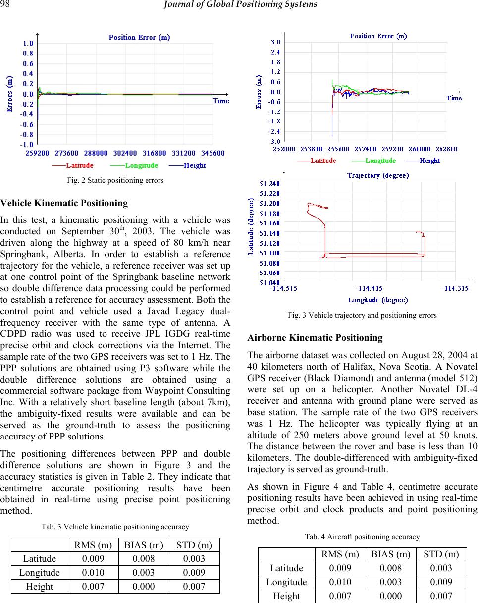 98 Journal of Global Positioning Systems Fig. 2 Static positioning errors Vehicle Kinematic Positioning In this test, a kinematic positioning with a vehicle was conducted on September 30th, 2003. The vehicle was driven along the highway at a speed of 80 km/h near Springbank, Alberta. In order to establish a reference trajectory for the vehicle, a reference receiver was set up at one control point of the Springbank baseline network so double difference data processing could be performed to establish a reference for accuracy assessment. Both the control point and vehicle used a Javad Legacy dual- frequency receiver with the same type of antenna. A CDPD radio was used to receive JPL IGDG real-time precise orbit and clock corrections via the Internet. The sample rate of the two GPS receivers was set to 1 Hz. The PPP solutions are obtained using P3 software while the double difference solutions are obtained using a commercial software package from Waypoint Consulting Inc. With a relatively short baseline length (about 7km), the ambiguity-fixed results were available and can be served as the ground-truth to assess the positioning accuracy of PPP solutions. The positioning differences between PPP and double difference solutions are shown in Figure 3 and the accuracy statistics is given in Table 2. They indicate that centimetre accurate positioning results have been obtained in real-time using precise point positioning method. Tab. 3 Vehicle kinematic positioning accuracy RMS (m) BIAS (m) STD (m) Latitude 0.009 0.008 0.003 Longitude 0.010 0.003 0.009 Height 0.007 0.000 0.007 Fig. 3 Vehicle trajectory and positioning errors Airborne Kinematic Positioning The airborne dataset was collected on August 28, 2004 at 40 kilometers north of Halifax, Nova Scotia. A Novatel GPS receiver (Black Diamond) and antenna (model 512) were set up on a helicopter. Another Novatel DL-4 receiver and antenna with ground plane were served as base station. The sample rate of the two GPS receivers was 1 Hz. The helicopter was typically flying at an altitude of 250 meters above ground level at 50 knots. The distance between the rover and base is less than 10 kilometers. The double-differenced with ambiguity-fixed trajectory is served as ground-truth. As shown in Figure 4 and Table 4, centimetre accurate positioning results have been achieved in using real-time precise orbit and clock products and point positioning method. Tab. 4 Aircraft positioning accuracy RMS (m) BIAS (m) STD (m) Latitude 0.009 0.008 0.003 Longitude 0.010 0.003 0.009 Height 0.007 0.000 0.007 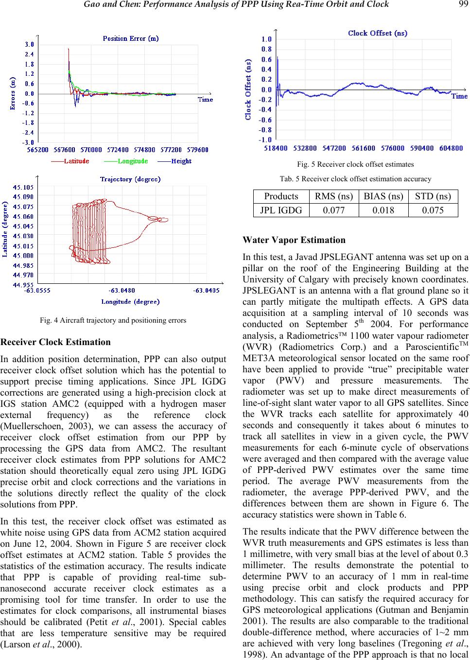 Gao and Chen: Performance Analysis of PPP Using Rea-Time Orbit and Clock 99 Fig. 4 Aircraft trajectory and positioning errors Receiver Clock Estimation In addition position determination, PPP can also output receiver clock offset solution which has the potential to support precise timing applications. Since JPL IGDG corrections are generated using a high-precision clock at IGS station AMC2 (equipped with a hydrogen maser external frequency) as the reference clock (Muellerschoen, 2003), we can assess the accuracy of receiver clock offset estimation from our PPP by processing the GPS data from AMC2. The resultant receiver clock estimates from PPP solutions for AMC2 station should theoretically equal zero using JPL IGDG precise orbit and clock corrections and the variations in the solutions directly reflect the quality of the clock solutions from PPP. In this test, the receiver clock offset was estimated as white noise using GPS data from ACM2 station acquired on June 12, 2004. Shown in Figure 5 are receiver clock offset estimates at ACM2 station. Table 5 provides the statistics of the estimation accuracy. The results indicate that PPP is capable of providing real-time sub- nanosecond accurate receiver clock estimates as a promising tool for time transfer. In order to use the estimates for clock comparisons, all instrumental biases should be calibrated (Petit et al., 2001). Special cables that are less temperature sensitive may be required (Larson et al., 2000). Fig. 5 Receiver clock offset estimates Tab. 5 Receiver clock offset estimation accuracy Products RMS (ns) BIAS (ns) STD (ns) JPL IGDG 0.077 0.018 0.075 Water Vapor Estimation In this test, a Javad JPSLEGANT antenna was set up on a pillar on the roof of the Engineering Building at the University of Calgary with precisely known coordinates. JPSLEGANT is an antenna with a flat ground plane so it can partly mitigate the multipath effects. A GPS data acquisition at a sampling interval of 10 seconds was conducted on September 5th 2004. For performance analysis, a Radiometrics 1100 water vapour radiometer (WVR) (Radiometrics Corp.) and a ParoscientificTM MET3A meteorological sensor located on the same roof have been applied to provide “true” precipitable water vapor (PWV) and pressure measurements. The radiometer was set up to make direct measurements of line-of-sight slant water vapor to all GPS satellites. Since the WVR tracks each satellite for approximately 40 seconds and consequently it takes about 6 minutes to track all satellites in view in a given cycle, the PWV measurements for each 6-minute cycle of observations were averaged and then compared with the average value of PPP-derived PWV estimates over the same time period. The average PWV measurements from the radiometer, the average PPP-derived PWV, and the differences between them are shown in Figure 6. The accuracy statistics were shown in Table 6. The results indicate that the PWV difference between the WVR truth measurements and GPS estimates is less than 1 millimetre, with very small bias at the level of about 0.3 millimeter. The results demonstrate the potential to determine PWV to an accuracy of 1 mm in real-time using precise orbit and clock products and PPP methodology. This can satisfy the required accuracy for GPS meteorological applications (Gutman and Benjamin 2001). The results are also comparable to the traditional double-difference method, where accuracies of 1~2 mm are achieved with very long baselines (Tregoning et al., 1998). An advantage of the PPP approach is that no local 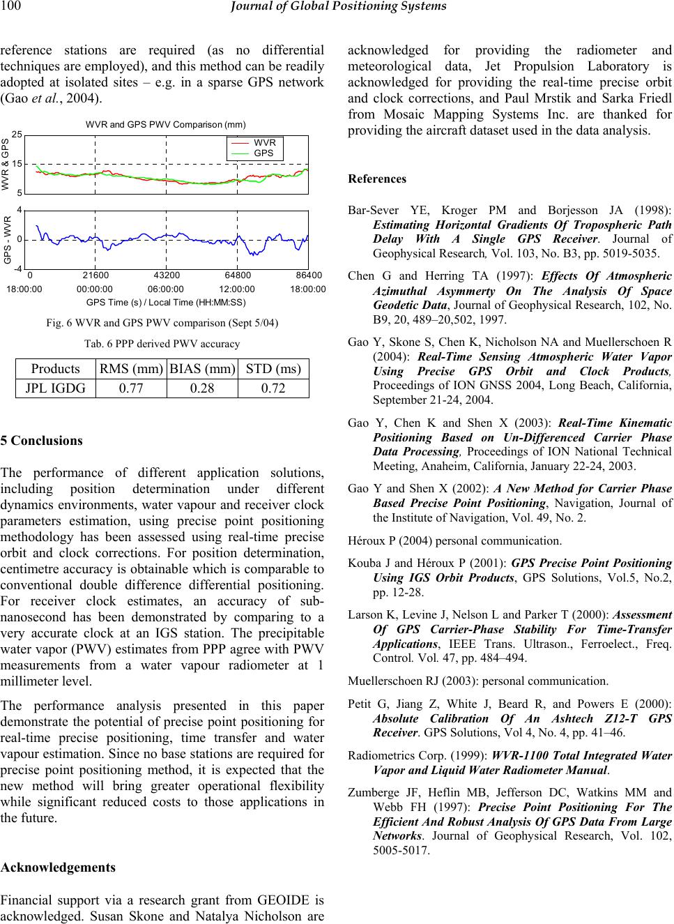 100 Journal of Global Positioning Systems reference stations are required (as no differential techniques are employed), and this method can be readily adopted at isolated sites – e.g. in a sparse GPS network (Gao et al., 2004). 5 15 25 WVR and GPS PWV Comparison (mm) WVR & GPS WVR GPS 0 21600 43200 64800 86400 -4 0 4 GPS - WVR 18:00:0000:00:00 06:00:00 12:00:00 18:00:0 0 GPS Time ( s ) / Local Time ( HH:MM:SS ) Fig. 6 WVR and GPS PWV comparison (Sept 5/04) Tab. 6 PPP derived PWV accuracy Products RMS (mm) BIAS (mm) STD (ms) JPL IGDG 0.77 0.28 0.72 5 Conclusions The performance of different application solutions, including position determination under different dynamics environments, water vapour and receiver clock parameters estimation, using precise point positioning methodology has been assessed using real-time precise orbit and clock corrections. For position determination, centimetre accuracy is obtainable which is comparable to conventional double difference differential positioning. For receiver clock estimates, an accuracy of sub- nanosecond has been demonstrated by comparing to a very accurate clock at an IGS station. The precipitable water vapor (PWV) estimates from PPP agree with PWV measurements from a water vapour radiometer at 1 millimeter level. The performance analysis presented in this paper demonstrate the potential of precise point positioning for real-time precise positioning, time transfer and water vapour estimation. Since no base stations are required for precise point positioning method, it is expected that the new method will bring greater operational flexibility while significant reduced costs to those applications in the future. Acknowledgements Financial support via a research grant from GEOIDE is acknowledged. Susan Skone and Natalya Nicholson are acknowledged for providing the radiometer and meteorological data, Jet Propulsion Laboratory is acknowledged for providing the real-time precise orbit and clock corrections, and Paul Mrstik and Sarka Friedl from Mosaic Mapping Systems Inc. are thanked for providing the aircraft dataset used in the data analysis. References Bar-Sever YE, Kroger PM and Borjesson JA (1998): Estimating Horizontal Gradients Of Tropospheric Path Delay With A Single GPS Receiver. Journal of Geophysical Research, Vol. 103, No. B3, pp. 5019-5035. Chen G and Herring TA (1997): Effects Of Atmospheric Azimuthal Asymmerty On The Analysis Of Space Geodetic Data, Journal of Geophysical Research, 102, No. B9, 20, 489–20,502, 1997. Gao Y, Skone S, Chen K, Nicholson NA and Muellerschoen R (2004): Real-Time Sensing Atmospheric Water Vapor Using Precise GPS Orbit and Clock Products, Proceedings of ION GNSS 2004, Long Beach, California, September 21-24, 2004. Gao Y, Chen K and Shen X (2003): Real-Time Kinematic Positioning Based on Un-Differenced Carrier Phase Data Processing, Proceedings of ION National Technical Meeting, Anaheim, California, January 22-24, 2003. Gao Y and Shen X (2002): A New Method for Carrier Phase Based Precise Point Positioning, Navigation, Journal of the Institute of Navigation, Vol. 49, No. 2. Héroux P (2004) personal communication. Kouba J and Héroux P (2001): GPS Precise Point Positioning Using IGS Orbit Products, GPS Solutions, Vol.5, No.2, pp. 12-28. Larson K, Levine J, Nelson L and Parker T (2000): Assessment Of GPS Carrier-Phase Stability For Time-Transfer Applications, IEEE Trans. Ultrason., Ferroelect., Freq. Control. Vol. 47, pp. 484–494. Muellerschoen RJ (2003): personal communication. Petit G, Jiang Z, White J, Beard R, and Powers E (2000): Absolute Calibration Of An Ashtech Z12-T GPS Receiver. GPS Solutions, Vol 4, No. 4, pp. 41–46. Radiometrics Corp. (1999): WVR-1100 Total Integrated Water Vapor and Liquid Water Radiometer Manual. Zumberge JF, Heflin MB, Jefferson DC, Watkins MM and Webb FH (1997): Precise Point Positioning For The Efficient And Robust Analysis Of GPS Data From Large Networks. Journal of Geophysical Research, Vol. 102, 5005-5017. |