Paper Menu >>
Journal Menu >>
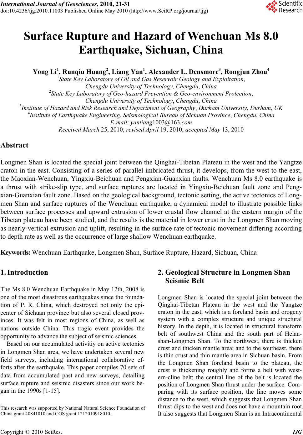 International Journal of Geosciences, 2010, 21-31 doi:10.4236/ijg.2010.11003 Published Online May 2010 (http://www.SciRP.org/journal/ijg) Copyright © 2010 SciRes. IJG Surface Rupture and Hazard of Wenchuan Ms 8.0 Earthquake, Sichuan, China Yong Li1, Runqiu Huang2, Liang Yan1, Alexander L. Densmore3, Rongjun Zhou4 1State Key Laboratory of Oil and Gas Reservoir Geology and Exploitation, Chengdu University of Technology, Chengdu, China 2State Key Laboratory of Geo-hazard Prevention & Geo-environment Protection, Chengdu University of Technology, Chengdu, China 3Institute of Hazard and Risk Research and Department of Geography, Durham University, Durham, UK 4Institute of Earthquake Engineering, Seismological Bureau of Sichuan Province, Chengdu, China E-mail: yanliang1003@163.com Received March 25, 2010; revised April 19, 2010; accepted May 13, 2010 Abstract Longmen Shan is located the special joint between the Qinghai-Tibetan Plateau in the west and the Yangtze craton in the east. Consisting of a series of parallel imbricated thrust, it develops, from the west to the east, the Maoxian-Wenchuan, Yingxiu-Beichuan and Pengxian-Guanxian faults. Wenchuan Ms 8.0 earthquake is a thrust with strike-slip type, and surface ruptures are located in Yingxiu-Beichuan fault zone and Peng- xian-Guanxian fault zone. Based on the geological background, tectonic setting, the active tectonics of Long- men Shan and surface ruptures of the Wenchuan earthquake, a dynamical model to illustrate possible links between surface processes and upward extrusion of lower crustal flow channel at the eastern margin of the Tibetan plateau have been studied, and the results is the material in lower crust in the Longmen Shan moving as nearly-vertical extrusion and uplift, resulting in the surface rate of tectonic movement differing according to depth rate as well as the occurrence of large shallow Wenchuan earthquake. Keywords: Wenchuan Earthquake, Longmen Shan, Surface Rupture, Hazard, Sichuan, China 1. Introduction The Ms 8.0 Wenchuan Earthquake in May 12th, 2008 is one of the most disastrous earthquakes since the founda- tion of P. R. China, which destroyed not only the epi- center of Sichuan province but also several closed prov- inces. It was felt in most regions of China, as well as nations outside China. This tragic event provides the opportunity to advance the subject of seismic sciences. Based on our accumulated activitiy on active tectonics in Longmen Shan area, we have undertaken several new field surveys, including international collaborative ef- forts after the earthquake. This paper compiles 70 sets of data from accumulated past and new surveys, detailing surface rupture and seismic disasters since our work be- gan in the 1990s [1-15]. 2. Geological Structure in Longmen Shan Seismic Belt Longmen Shan is located the special joint between the Qinghai-Tibetan Plateau in the west and the Yangtze craton in the east, which is a foreland basin and orogeny system with a complex structure and unique structural history. In the depth, it is located in structural transform belt of southwest China and the south part of Helan- shan-Longmen Shan. To the northwest, there is thicken crust and thicken mantle area; and to the southeast, there is thin crust and thin mantle area in Sichuan basin. From the Longmen Shan foreland basin to the plateau, the crust is thickening roughly and forms a belt with west- ern-cline belt; the central line of the belt is located the position of Longmen Shan thrust under the surface. Com- paring with its surface position, the line moves some distance to the west, which suggests that Longmen Shan thrust dips to the west and does not have a mountain root. It also suggests that Longmen Shan is an Intracontinental This research was supported by National Natural Science Foundation o f China grant 40841010 and CGS grant 1212010918010.  22 Y. LI ET AL. mountain chain and an independent tectonic uploading system. The isostatic gravity anomaly in Longmen Shan and joint regions show that the crust in this area is still unsta- ble. The figures in Longmen Shan are positive and the figures in Longquan Shan and the area to the east are negative while the figures in the area between them are around zero. Since the Cenozoic, at least 5-10 km strata have eroded in uplift rate of 0.6 mm/a. The survey data in recent years shows that there is an uplift rate in 0.3-0.4 mm/a in Jiuding Shan [1,16]. According to the regional geological setting, this area, from northwest to southeast, consists of Songpan-Ganzi Orogeny (main part), Longmen Shan thrust belt, foreland basin and forebulge; all of these four parts form a com- plete tectonic system. We would introduce the east mar- gin of Qinghai-Tibetan Plateau as three geological units: Songpan-Ganzi orogenic belt (main part), Longmen Shan thrust belt and foreland basin [1-15]. 3. Surface Rupture of the Wenchuan Earthquake After the earthquake, a number of research institutions have published basic parameters and focal mechanisms. However, those data are different depending on different sources and methods. The USGS recorded that the Mw. is 7.9, the epicenter is located in Yingxiu, Wenchuan (31.099, 103.279), the focal depth is 19 km, the rupture length is 300 km and the duration is 120 seconds, trend- ing 229° and fracture plane dipping 33° with strike-slip. According to the basic parameters and the focal mecha- nism solution, the Wenchuan earthquake had the follow- ing two characteristics: 1) it was a shallow hypocenter earthquake and took place in the brittle-ductility trans- form belt in 12 km-19 km depth with enormous destruc- tivity; 2) it belongs to thrusting and dextral strike-slip one and from southwest to northeast, it propagated in one direction. The release process of strain was relatively sl- ow and may have led to a greater intensity of aftershocks and longer duration. The intensity of the earthquake had an oval-shaped distribution and its long axis was in a northeast direction. In this direction, the casualties and property loss was much bigger than other directions. According to the surface rupture survey (Figure 1) af- ter the earthquake, the Wenchuan earthquake faults have characteristics of fragile, post-earthquake surface linear image is apparent, cutting a wide range of terrain units. They are located in Yingxiu-Beichuan fault zone (central zone), Pengxian-Guanxian fault zone (front fault) which only a small amount of surface rupture are found and Maoxian-Wenchuan fault zone (back fault) which sur- face rupture have not yet been found. Those surface rup- ture extend in northeast direction (in NE 30º-70º, most in NE 50º-60º) and trend to northwest (30º-80º). They dis- tribute along the striking in a few meters to 200 meters range and were also distributed along the Yingxiu-Beich- uan fault and Pengxian-Guanxian fault. Figure 1. Distribution of surface rupture of Wenchuan Earthquake in Longmen Shan. Copyright © 2010 SciRes. IJG  Y. LI ET AL. Copyright © 2010 SciRes. IJG 23 3.1. Surface Rupture of Yingxiu-Beichuan Fault The Yingxiu-Beichuan fault (Figures 1-3) is the Wen- chuan earthquake’s main earthquake fault. The linear characteristics of the earthquake surface rupture belt are apparent. It starts from Yingxiu, Wenchuan in the south- west and then extends to Hongkou, Longmen Shan town (Baishuihe), Donglinsi, Hongbai, Qingping, Chaping, Leigu, Beichuan, Chenjiaba, Guixi, and then ends in Shikanzi, Pingwu, a distance of about 220 km. It was distributed along the strike of Yingxiu-Beichuan fault and disappears in the southwest 10 km of Yingxiu, be- longing to the single-side and multi-point type rupture with thrust characteristics. Its plane had a steep dip angle and cut a wide range of terrain units, including mountain bedrocks, river terraces, alluvial fans, highways and bri- dges with bridge collapse or road displacement. Its ver- tical offsets were in the range of 1.60-6.20 m and its horizontal offsets were in the range 0.20-6.50, striking NE 30°-50° and trending northwest. The average vertical offset was 3.4 m and horizontal 2.9 m, the biggest offset being 10.3 ± 0.2 m in Maoba, Beichuan (vertical fault) and 6.8 ± 0.2 m in Leigu (horizontal offset). The ratio between thrust and dextral strike-slip components are 1:1, indicating the existence of thrust movement and dextral strike-slip movement, the amount of thrust movement being equal to the dextral strike-slip movement. Basing this and according to the current surface data obtained from the survey, we calculated vertical and horizontal offsets in four parts of Yingxiu-Beichuan sur- face rupture. The preliminary analysis results are: 1) the epicenter located in the vicinity of Yingxiu (Figure 1) is Figure 2. The vertical displacement along the Yingxiu-Beichuan Fault in Wenchuan Earthquake. Figure 3. The horizontal displacement along the Yingxiu-Beichuan fault in Wenchuan Earthquake.  Y. LI ET AL. Copyright © 2010 SciRes. IJG 24 not the position where the biggest offset is located; the biggest vertical and horizontal offsets are 10.3 ± 0.2 m (vertical offset) and 6.8 ± 0.2 m (horizontal offset) in Beichuan. According to Wenchuan earthquake focal me- chanisms solution, the greatest offset of the main shock is 9 m-10 m. As a result, the surface rupture is smaller than the biggest displacement under ground; the biggest offset are 60%-70% of the biggest offset under ground; 2) by surface offsets, the Yingxiu-Beichuan fault can be divided into two high-value and two low-value zones. The two high-value zones are located in the southern part of Hongkou, Yingxiu and the northern part of the Leigu, Beichuan-Dengjiaba area and the two low-value zones are located in mid-south part of the Baishuihe-Chaping area and Huangjiaba-Shikanzi, Pingwu area. These four sections are divided by Xiaoyudong fault, Leigu fault and Dengjiaba fault; the two high-value areas being cau- sed by the Xiaoyudong and Leigu faults; 3) Chen [17] use the global seismic network data to confirm two larg- est static sliding displacement areas, which are located at area between epicenter and northeast 100 km to the epi- center and 150 km northeast of the epicenter; the two largest displacement of the slip surface locate in the two high-value areas, indicating that the largest displacement in the surface are the response to the displacement under ground; 4) compared the surface rupture of earthquake with before, the places in Yingxiu, Leigu, Baishuihe and Gaoyuan with historical earthquake rupture are also the places with new rupture[3-8,12,15]. In the places with historical earthquake since Quaternary, there will be new strong earthquake in the future. 3.2. Surface Rupture of Pengxian-Guanxian Fault The Pengxian-Guanxian fault (Figures 1 and 4) expe- rienced surface fractures in this earthquake. The surface rupture started from Xiang’e, Dujiangyan and extended to Cifeng, Pengzhou, Bailu, Jinhua, Hanwang and Sang- zao over a total distance of about 40-50 km, character- ized by dextral strike-slips shortening with steep dipping. The hanging wall was in the northwest and its foot wall in the southeast. The vertical offset was 0.39-2.70 m and the horizontal offset was 0.20-0.70 m (the average verti- cal offset was 1.6 meters with an average horizontal off- set of 0.6 meter), indicating the existence of thrust dis- placement and dextral strike-slip displacement and thrust displacement is greater than the dextral strike-slip dis- placement, showing thrust and shortening characteristics. Compared with the surface rupture of the Yingxiu-Be- ichuan, the fault rupture is far less than the Beichuan- Yingxiu fault rupture and it has a relatively short length of the rupture and vertical offset; and on the other hand, the horizontal offset dispalcement is relatively small, the thrust displacement is main. 3.3. Surface Rupture of Xiaoyudong Fault The fault (Figures 1, 5 and 6) is located between Ying- xiu-Beichuan fault and Pengxian-Guanxian fault and is a new fault being discovered after the earthquake, showing that the fault is a transformed fault between the Ying- xiu-Beichuan fault and the Pengxian-Guanxian fault. The fault, striking south-north, extends about 15 km through Xiaoyudong Bridge; the stretch of the surface rupture is stable and we have confirmed more than 10 rupture points. The southwest block is a hanging wall and the northeast block is foot wall with an average vertical offset of 1.0 meter and an average horizontal offset of 2.3 meters (vertical offset/horizontal offset ratio is 1:1), showing the vertical offset is equal to the horizontal off- set and, from south to north, the thrust displacement is increasing. Figure 4. The vertical displacement along the Pengxian-Guanxian fault in Wenchuan Earthquake.  Y. LI ET AL. 25 Figure 5. The vertical displacement along the Xiaoyudong fault in Wenchuan Earthquake. Figure 6. The horizontal displacement along the Xiaoyudong fault in Wenchuan Earthquake. 3.4. Surface Rupture of Leigu Fault This fault (Figures 1 and 7) belongs to Yingxiu-Beichuan fault belt and between two parallel northeast striking faults. The fault’s surface rupture is very complex and it is also a new fault discovered after the earthquake, show- ing that it is a transform fault between those two parallel Yingxiu-Beichuan faults, which has been named Leigu fault by us. The fault, striking south-north, extends 3-5 km from south to north. The surface rupture pattern is stable and we have confirmed that more than 10 rupture points. Its southwest block is hanging wall and the northeast block is foot wall. The largest vertical offset is 2.2 ± 0.5 m and the largest horizontal offset is 1.9 ± 0.1 m (the average vertical offset is 1.8 m and the average horizontal offset is 1.4 m). In the surface rupture, there are obvious changes from the north to the south, changing from striking south-north in the north to striking NWW in the south, which shows vertical and sinistral horizontal offset in the north (a channel has been offset vertically 1.9 m and horizontally 1.3 m); and, in the south, the rupture zone shows vertical and dextral offset (a house foundation has been offset vertically 1.5 m and 0.5 m and dextral 1.3 m and 0.3 m). The vertical offset with horizontal offset ratio is 1:1, showing the thrust displacement is equal to the strike-slip displacement and, from south to north, the thrust changes Copyright © 2010 SciRes. IJG  Y. LI ET AL. Copyright © 2010 SciRes. IJG 26 Figure 7. The vertical displacement along the Leigu fault in Wenchuan Earthquake. bigger. It was noticed that in the north, the fault is sinis- tral strike-slip and, in the south, it appears to be a dextral strike-slip. 3.5. The landform of Surface Rupture According to our field observation of the surface rupture, it had various forms, mainly showing as ridge offsets, alluvial fan offsets, terrace offset, slopes offsets, channel offsets, path offsets, highway offsets, cement road over- lays, structural fractures, sag ponds, ground cracks, ear- thquake domes, pressure ridge and other types, of which road scarps are easy to identify. In Yingxiu region, the surface rupture are showed in structural cracks and road deformation (asymmetrical fold ridge) and graben; in Shengxigou and Gaoyuan, the surface are showed road scarps, road deformation and pressure ridge; in Bajiaomiao, the surface rupture are showed in fault scarps. The width of surface rupture is different along the fault, but on the whole, it is generally less than 20 meters. Strong deformation is distributed in the hanging block of the thrust fault and the foot block has no obvious deformation, or only has deformation in the vicinity of the fault. 3.6. Dip of Surface Rupture The Yingxiu-Beichuan fault’s surface ruptures are gen- erally steep scrapes; the northwest block is hanging wall and southeast block is foot wall, indicating that the frac- ture plane should trend northwest. But the plane is diffi- cult to be discovered; in Bajiaomiao, Hongkou, the plane was directly exposed at the surface. It tends to northwest with dip angle 80°-86° and its hanging wall is composed of upper Triassic Xujiahe coal-bearing strata and its foot block is loose gravels. The scratches can be distinct in the plane, indicating high-angle thrust characteristics. As a result, in the Yingxiu-Beichuan fault, the northwest tending fault in high-angle should be representative. However, in Gaoyuan, Hongkou, Yingxiu-Beichuan fault’s rupture surface trend to southeast. The plane here is also showed as a very steep scrapes, but the northwest block is foot side and southeast is hanging side, which indicates that the plane should trend to northwest. As a result, we think that Yingxiu-Beichuan fault’s surface rupture should be northwest trending high-angle surface, but in some areas, the tendency could be reversed from northwest to southeast. The Wenchuan earthquake’s focal mechanisms soluti- on reveals that the dip angle of plane is only 33°-39° [17]. It is obvious that the surface crack plane is different from one calculated by focal mechanisms solution: the dip angle is gentle when deeper. This characteristic is also similar to an imbricate thrust fault’s structural features. 3.7. Surface Rupture and Shortening Rate Although in the Yingxiu-Beichuan fault there are differ- ent structural shortening forms, including road offset and road overlay, the proper measurement position of surface deformation is less. In a cement road in Gaoyuan, we measured the pressure ridge and the thrust overlay, sho- wing a clear structural shortening phenomenon. In the cement road, we measured surface deformation in detail, indicating that the structural shortening rate of this sec- tion is 7.61 percent and that the biggest structural short- ening rate of the pressure ridge is 28.6 percent. The Longmen Shan is the most typical klippe zone in China; it has a structural shortening rate of 42-43% [1,3- 8]. The result is 7.61%-28.6% in Gaoyuan, showing the clear structural shortening rate in Wenchuan Earthquake.  Y. LI ET AL. 27 3.8. Rupture Process of Wenchuan Earthquake Although the surface rupture in Bajiaomiao is also steep scarp as the main form; its hangling wall is Upper Trias- sic Xujiahe coal-bearing strata and its foot wall is loose gravel. But the scrape marks have preserved the evidence for the process analysis of Wenchuan earthquake. The scrapes plane strikes to N60°E, trending to N300°W with a dip angle of 85°. We discovered two scratches in the plane. The first one is nearly vertical, mainly distrib- uting in upper and lower parts of the plane, while the second one is nearly horizontal, mainly locating in the lower part of the plane. In the plane of the scrapes, we can observe three kinds of cross cutting relationships between nearly vertical and horizontal scratches: a nearly vertical one cutting the nearly horizontal one, a nearly horizontal one cutting the nearly vertical one and a nearly vertical one in the top gradually changing to the nearly horizontal one in the bottom. In view of the Upper Triassic Xujiahe coal-bearing strata in the hanging block and the loose gravel in the foot block, the scratch preserved in the hangling wall bedrock should be the evidence of foot wall loose gravel in the movement process. As a result, the upper marks preserved in the hangling wall should be the early evi- dence of the rupture process of the earthquake and the lower marks preserved in the hanging wall should be the late evidence of the rupture process. For this reason, we speculate that the nearly vertical scratches in the top recorded the thrust movement early, while the scratches in the bottom recorded the strike-slip movement lately. According to these three different kin- ds of cross cutting relationship of scratches, we think that the late movement is oblique. According to the focal mechanisms solution, Chen [17] thought that the Wenchuan earthquake can be divided into 7 stages, and that, in the beginning stages, the move- ment showed thrust and then gradually shifted to strike- slip movement lately. Yuji Yagi [18] has a similar view- point on the movement process of the devastating earth- quake which includes two phases: the first phase (0- 50 seconds) with 6.4 m thrust and the second phase (60- 120 seconds) with 4.6 m strike-slip. As a result, the scratches of the surface rupture reveal the process confirmed by the focal mechanism solution, which is that the thrust movement occurred early and the strike-slip movement occurred lately. 4. Discussion on Kinematic of Active Tectonics in Longmen Shan and Wenchuan Earthquake Indo-Asia collision is the most important events in Ce- nozoic, which results in the uplift, deformation and thickening of Qinghai-Tibetan Plateau. The event and its impact to Cenozoic geological structure has been noticed and discussed by geoscientists. Two well-known hy- potheses have been presented; one is a crustal thickening model [19] and the other one is a lateral extrusion mode [20].The former emphasizes on north-south crustal shor- tening and thickening, and the later emphasizes the east-extrusion along main faults. In the eastern margin of the Qinghai-Tibetan Plateau, there are two corresponding pattens which are: Avouac and Tapponnier [20] eastward thrusting mode, and England et al.’s dextral strike-slip mode. However, the active tectonics and Wenchuan earth- quake show the Longmen Shan fault is characterize by thrust and dextral strike-slip movement, which does not coincide with England and Molnar’s large scale dextral shear movement in the eastern margin of Qinghai-Ti- betan Plateau, and which also does not coincide with Avouac and Tapponnier [20] eastward thrusting mode in the eastern margin of the Qinghai-Tibetan Plateau. The performance of Longmen Shan fault zone has its uni- queness, which can not be explained in one single mode. According to the direction of surface movement sho- wed by GPS measurements [21,22], the northeast corner of Qinghai-Tibetan Plateau consisting of Longmen Shan fault and Kunlun Shan fault has the characteristics of northeastward (Qingling direction) extruding out, which means that when the Songpan-Ganzi block in eastern Qinghai-Tibet moved to the east, because of the blocking of Yangtze platform, it was forced to move to Qinling Mountains in the northeast and resulted in the characters with thrust and dextral strike-slip movement mode in Longmen Shan. The West Qinling fault is thrust with sinistral strike-slip movement and the blocks between Longriba fault and east Kunlun fault is also northeastern extruding out (Figure 8). 5. Discussing of Dynamics Mechanism of Active Tectonics in Longmen Shan and Wenchuan Earthquake According to GPS measurements, India plate is moving to the north in 50 mm a-1, and different blocks in the eastern margin of Qinghai-Tibetan Plateau have signifi- cantly different movement rates. The Songpan-Ganzi block in the south has a faster horizontal movement rate than the Songpan-Ganzi block in the north. Active tec- tonics research [3-8,12,15] shows that the horizontal movement rate in Longmen Shan is small (1-3 mm a-1), so is its uplift rate (0.35-0.40 mm a-1) [1]. Its move- ment mode is characterized by thrust with dextral strike-slip. But Longmen Shan is the steepest mountain around Qinghai-Tibetan Plateau, in the range of more than 30 kilometers, it uplifts from 700 meters above sea level to more than 5000 meters. The small surface slipping rate Copyright © 2010 SciRes. IJG  Y. LI ET AL. Copyright © 2010 SciRes. IJG 28 Wenchuan Earthquake coincide with the depth of his- torical strong earthquake and all of them are shallow earthquakes, which coincide with the depth of 20 km in low-velocity layer and also coincide with the uplift depth of the top of lower crust [9-11]. As a result, in the process of Qinghai-Tibetan Plate- au’s movement to the east, blocked by the basement of the Sichuan Basin, the lithosphere is not synchronized as a whole flow to the east and the flow velocity is different in different layers. This results in lower crust material in the Longmen Shan moving as nearly-vertical extrusion and uplift [23], resulting in the surface rate of tectonic movement differing according to depth rate as well as the occurrence of large shallow Wenchuan earthquake (Fig- ure 9). Figure 8. Surface movement, epicenter and tectonic frame- work in Eastern Qinghai-Tibetan plateau. does not only coincide with the high and steep mountain, but also does not coincide with the fact of the strong earthquake of Ms 8.0. As a result, in the Songpan-Ganzi block and Longmen Shan in the northeast margin of Qinghai-Tibetan Plateau, the rate of surface movement does not coincide with the deep tectonic movement rate. The deep structural process must be thought about in the seismic hazard assessment. 6. Geological Hazard Caused by Wenchuan Earthquake The Wenchuan Earthquake is the most destructive in intensity and the vastest of affected area in China since 1949. The area of the heavily destroyed region is more than 100,000 km2. It has the most serious casualties after the Cicheng Earthquake (Inner Mongolia, 1290), the Huaxian Earthquake (Shanxi, 1556), the Haiyuan Earth- quake (Ningxia, 1920) and the Tangshan Earthquakes (Hebei, 1976). The Wenchuan earthquake’s focal mechanism solution shows that Wenchuan Earthquake’s focal depth is 12-19 km, belonging to shallow earthquake. In addition, we count the historical earthquake in Longmen Shan as the longi- tude [3-8,9-11]. The results show that Longmen Shan tectonic earthquake in lower magnitude was in depth of 5-15 km in advantage and the strong earthquake was in depth of 15-20 km. Obviously, it is clear that the depth of The hazards caused by the Wenchuan Ms 8.0 Earth- quake is known by next main characteristics: 1) seismic waves have propagated with strong ground motion to damage construction; 2) surface rupture zone directly Figure 9. A dynamical model to illustrate possible links between surface processes and upward extrusion of lower crustal flow channel at the eastern margin of the Tibetan plateau. 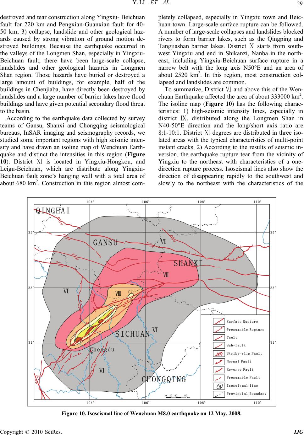 Y. LI ET AL. Copyright © 2010 SciRes. IJG 29 destroyed and tear construction along Yingxiu- Beichuan fault for 220 km and Pengxian-Guanxian fault for 40- 50 km; 3) collapse, landslide and other geological haz- ards caused by strong vibration of ground motion de- stroyed buildings. Because the earthquake occurred in the valleys of the Longmen Shan, especially in Yingxiu- Beichuan fault, there have been large-scale collapse, landslides and other geological hazards in Longmen Shan region. Those hazards have buried or destroyed a large amount of buildings, for example, half of the buildings in Chenjiaba, have directly been destroyed by landslides and a large number of barrier lakes have flood buildings and have given potential secondary flood threat to the basin. According to the earthquake data collected by survey teams of Gansu, Shanxi and Chongqing seismological bureaus, InSAR imaging and seismography records, we studied some important regions with high seismic inten- sity and have drawn an isoline map of Wenchuan Earth- quake and distinct the intensities in this region (Figure 10). District is located in YingxiuⅪ-Hongkou, and Leigu-Beichuan, which are distribute along Yingxiu- Beichuan fault zone’s hanging wall with a total area of about 680 km2. Construction in this region almost com- pletely collapsed, especially in Yingxiu town and Beic- huan town. Large-scale surface rupture can be followed. A number of large-scale collapses and landslides blocked rivers to form barrier lakes, such as the Qingping and Tangjiashan barrier lakes. District starts from soutⅩh- west Yingxiu and end in Shikanzi, Nanba in the north- east, including Yingxiu-Beichuan surface rupture in a narrow belt with the long axis N50°E and an area of about 2520 km2. In this region, most construction col- lapsed and landslides are common. To summarize, District and above this of the WeⅥn- chuan Earthquake affected the area of about 333000 km2. The isoline map (Figure 10) has the following charac- teristics: 1) high-seismic intensity lines, especially in district , distributed aloⅨng the Longmen Shan in N40-50°E direction and the long/short axis ratio are 8:1-10:1. District degrees are distributed in three isⅪo- lated areas with the typical characteristics of multi-point instant cracks. 2) According to the results of seismic in- version, the earthquake rupture tear from the vicinity of Yingxiu to the northeast with characteristics of a one- direction rupture process. Isoseismal lines also show the direction of disappearing rapidly to the southwest and slowly to the northeast with the characteristics of the Figure 10. Isoseismal line of Wenchuan M8.0 earthquake on 12 May, 2008. 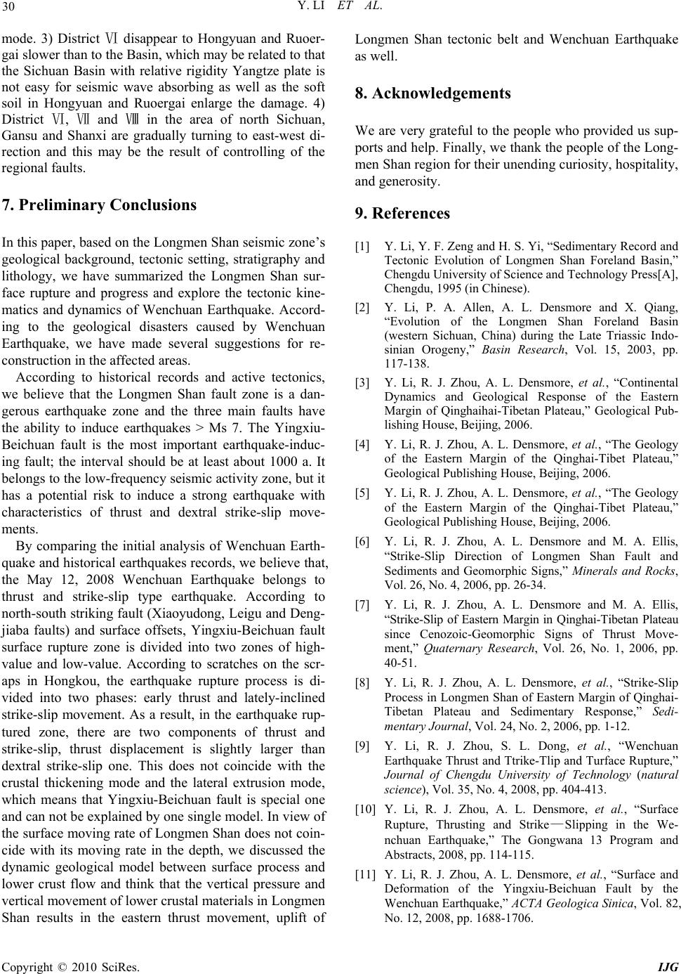 Y. LI ET AL. Copyright © 2010 SciRes. IJG 30 mode. 3) District disappear to Hongyuan and RuoeⅥr- gai slower than to the Basin, which may be related to that the Sichuan Basin with relative rigidity Yangtze plate is not easy for seismic wave absorbing as well as the soft soil in Hongyuan and Ruoergai enlarge the damage. 4) District , and in the area ⅥⅦ Ⅷof north Sichuan, Gansu and Shanxi are gradually turning to east-west di- rection and this may be the result of controlling of the regional faults. 7. Preliminary Conclusions In this paper, based on the Longmen Shan seismic zone’s geological background, tectonic setting, stratigraphy and lithology, we have summarized the Longmen Shan sur- face rupture and progress and explore the tectonic kine- matics and dynamics of Wenchuan Earthquake. Accord- ing to the geological disasters caused by Wenchuan Earthquake, we have made several suggestions for re- construction in the affected areas. According to historical records and active tectonics, we believe that the Longmen Shan fault zone is a dan- gerous earthquake zone and the three main faults have the ability to induce earthquakes > Ms 7. The Yingxiu- Beichuan fault is the most important earthquake-induc- ing fault; the interval should be at least about 1000 a. It belongs to the low-frequency seismic activity zone, but it has a potential risk to induce a strong earthquake with characteristics of thrust and dextral strike-slip move- ments. By comparing the initial analysis of Wenchuan Earth- quake and historical earthquakes records, we believe that, the May 12, 2008 Wenchuan Earthquake belongs to thrust and strike-slip type earthquake. According to north-south striking fault (Xiaoyudong, Leigu and Deng- jiaba faults) and surface offsets, Yingxiu-Beichuan fault surface rupture zone is divided into two zones of high- value and low-value. According to scratches on the scr- aps in Hongkou, the earthquake rupture process is di- vided into two phases: early thrust and lately-inclined strike-slip movement. As a result, in the earthquake rup- tured zone, there are two components of thrust and strike-slip, thrust displacement is slightly larger than dextral strike-slip one. This does not coincide with the crustal thickening mode and the lateral extrusion mode, which means that Yingxiu-Beichuan fault is special one and can not be explained by one single model. In view of the surface moving rate of Longmen Shan does not coin- cide with its moving rate in the depth, we discussed the dynamic geological model between surface process and lower crust flow and think that the vertical pressure and vertical movement of lower crustal materials in Longmen Shan results in the eastern thrust movement, uplift of Longmen Shan tectonic belt and Wenchuan Earthquake as well. 8. Acknowledgements We are very grateful to the people who provided us sup- ports and help. Finally, we thank the people of the Long- men Shan region for their unending curiosity, hospitality, and generosity. 9. References [1] Y. Li, Y. F. Zeng and H. S. Yi, “Sedimentary Record and Tectonic Evolution of Longmen Shan Foreland Basin,” Chengdu University of Science and Technology Press[A], Chengdu, 1995 (in Chinese). [2] Y. Li, P. A. Allen, A. L. Densmore and X. Qiang, “Evolution of the Longmen Shan Foreland Basin (western Sichuan, China) during the Late Triassic Indo- sinian Orogeny,” Basin Research, Vol. 15, 2003, pp. 117-138. [3] Y. Li, R. J. Zhou, A. L. Densmore, et al., “Continental Dynamics and Geological Response of the Eastern Margin of Qinghaihai-Tibetan Plateau,” Geological Pub- lishing House, Beijing, 2006. [4] Y. Li, R. J. Zhou, A. L. Densmore, et al., “The Geology of the Eastern Margin of the Qinghai-Tibet Plateau,” Geological Publishing House, Beijing, 2006. [5] Y. Li, R. J. Zhou, A. L. Densmore, et al., “The Geology of the Eastern Margin of the Qinghai-Tibet Plateau,” Geological Publishing House, Beijing, 2006. [6] Y. Li, R. J. Zhou, A. L. Densmore and M. A. Ellis, “Strike-Slip Direction of Longmen Shan Fault and Sediments and Geomorphic Signs,” Minerals and Rocks, Vol. 26, No. 4, 2006, pp. 26-34. [7] Y. Li, R. J. Zhou, A. L. Densmore and M. A. Ellis, “Strike-Slip of Eastern Margin in Qinghai-Tibetan Plateau since Cenozoic-Geomorphic Signs of Thrust Move- ment,” Quaternary Research, Vol. 26, No. 1, 2006, pp. 40-51. [8] Y. Li, R. J. Zhou, A. L. Densmore, et al., “Strike-Slip Process in Longmen Shan of Eastern Margin of Qinghai- Tibetan Plateau and Sedimentary Response,” Sedi- mentary Journal, Vol. 24, No. 2, 2006, pp. 1-12. [9] Y. Li, R. J. Zhou, S. L. Dong, et al., “Wenchuan Earthquake Thrust and Ttrike-Tlip and Turface Rupture,” Journal of Chengdu University of Technology (natural science), Vol. 35, No. 4, 2008, pp. 404-413. [10] Y. Li, R. J. Zhou, A. L. Densmore, et al., “Surface Rupture, Thrusting and Strike—Slipping in the We- nchuan Earthquake,” The Gongwana 13 Program and Abstracts, 2008, pp. 114-115. [11] Y. Li, R. J. Zhou, A. L. Densmore, et al., “Surface and Deformation of the Yingxiu-Beichuan Fault by the Wenchuan Earthquake,” ACTA Geologica Sinica, Vol. 82, No. 12, 2008, pp. 1688-1706. 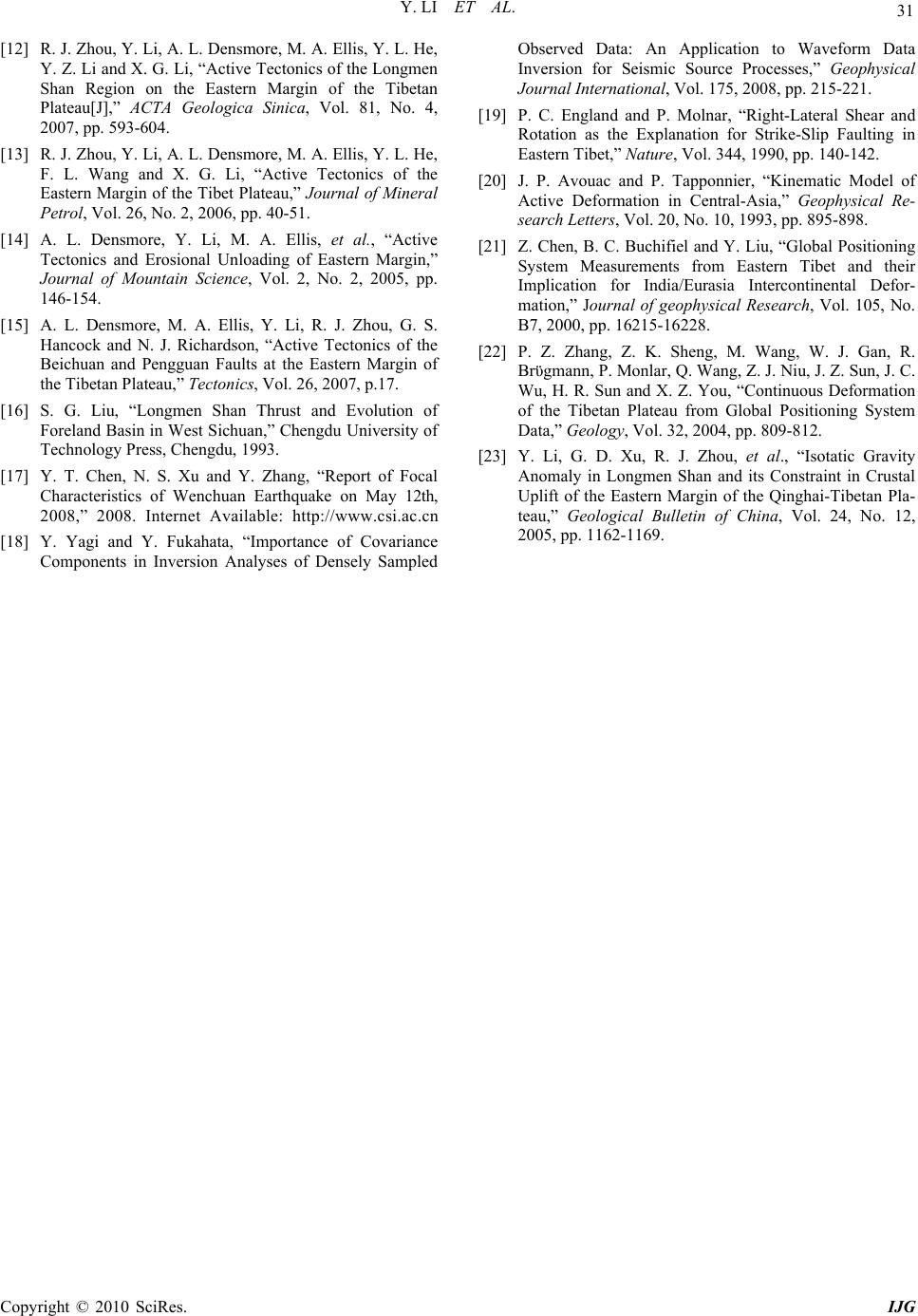 Y. LI ET AL. 31 [12] R. J. Zhou, Y. Li, A. L. Densmore, M. A. Ellis, Y. L. He, Y. Z. Li and X. G. Li, “Active Tectonics of the Longmen Shan Region on the Eastern Margin of the Tibetan Plateau[J],” ACTA Geologica Sinica, Vol. 81, No. 4, 2007, pp. 593-604. [13] R. J. Zhou, Y. Li, A. L. Densmore, M. A. Ellis, Y. L. He, F. L. Wang and X. G. Li, “Active Tectonics of the Eastern Margin of the Tibet Plateau,” Journal of Mineral Petrol, Vol. 26, No. 2, 2006, pp. 40-51. [14] A. L. Densmore, Y. Li, M. A. Ellis, et al., “Active Tectonics and Erosional Unloading of Eastern Margin,” Journal of Mountain Science, Vol. 2, No. 2, 2005, pp. 146-154. [15] A. L. Densmore, M. A. Ellis, Y. Li, R. J. Zhou, G. S. Hancock and N. J. Richardson, “Active Tectonics of the Beichuan and Pengguan Faults at the Eastern Margin of the Tibetan Plateau,” Tectonics, Vol. 26, 2007, p.17. [16] S. G. Liu, “Longmen Shan Thrust and Evolution of Foreland Basin in West Sichuan,” Chengdu University of Technology Press, Chengdu, 1993. [17] Y. T. Chen, N. S. Xu and Y. Zhang, “Report of Focal Characteristics of Wenchuan Earthquake on May 12th, 2008,” 2008. Internet Available: http://www.csi.ac.cn [18] Y. Yagi and Y. Fukahata, “Importance of Covariance Components in Inversion Analyses of Densely Sampled Observed Data: An Application to Waveform Data Inversion for Seismic Source Processes,” Geophysical Journal International, Vol. 175, 2008, pp. 215-221. [19] P. C. England and P. Molnar, “Right-Lateral Shear and Rotation as the Explanation for Strike-Slip Faulting in Eastern Tibet,” Nature, Vol. 344, 1990, pp. 140-142. [20] J. P. Avouac and P. Tapponnier, “Kinematic Model of Active Deformation in Central-Asia,” Geophysical Re- search Letters, Vol. 20, No. 10, 1993, pp. 895-898. [21] Z. Chen, B. C. Buchifiel and Y. Liu, “Global Positioning System Measurements from Eastern Tibet and their Implication for India/Eurasia Intercontinental Defor- mation,” Journal of geophysical Research, Vol. 105, No. B7, 2000, pp. 16215-16228. [22] P. Z. Zhang, Z. K. Sheng, M. Wang, W. J. Gan, R. Brϋgmann, P. Monlar, Q. Wang, Z. J. Niu, J. Z. Sun, J. C. Wu, H. R. Sun and X. Z. You, “Continuous Deformation of the Tibetan Plateau from Global Positioning System Data,” Geology, Vol. 32, 2004, pp. 809-812. [23] Y. Li, G. D. Xu, R. J. Zhou, et al., “Isotatic Gravity Anomaly in Longmen Shan and its Constraint in Crustal Uplift of the Eastern Margin of the Qinghai-Tibetan Pla- teau,” Geological Bulletin of China, Vol. 24, No. 12, 2005, pp. 1162-1169. Copyright © 2010 SciRes. IJG |