Engineering
Vol.5 No.5(2013), Article ID:31686,10 pages DOI:10.4236/eng.2013.55055
Evaluating Reference Crop Evapotranspiration (ETo) in the Centre of Guanzhong Basin
—Case of Xingping & Wugong, Shaanxi, China
1Civil Engineering Department, College of Water Resources and Architectural Engineering, Northwest A&F University, Yangling, China
2College of Water Resources and Architecture Engineering, Northwest A&F University, Yangling, China
Email: hussiaa@gmail.com, *jmlslx@yahoo.com.cn
Copyright © 2013 Hussein I. Ahmed, Junmin Liu. This is an open access article distributed under the Creative Commons Attribution License, which permits unrestricted use, distribution, and reproduction in any medium, provided the original work is properly cited.
Received January 29, 2013; revised March 8, 2013; accepted March 15, 2013
Keywords: Reference evapotranspiration; Part of Baoyang Irrigation Area; Meteorological Data; FAO Penman-Monteith Equation
ABSTRACT
In this paper, the Penman-Monteith method was applied to evaluate the reference crop evapotranspiration. A reliable estimation of the reference evapotranspiration (ETo) is of critical importance and required accurate estimates to close the water balance. The aim of this paper is estimating the reference evapotranspiration (ETo) as preliminary to use for groundwater modeling in the area. Based on FAO-Penman-Monteith method, ETo calculator software was applied. Meteorological data within this study were obtained from two gauges stations (Xing ping and Wu gong) and available literatures. The results indicated that the values of ETo for a period (1981-2009)—29 years—in two stations approximately the same. Specifically, is ranged between 0.4 - 6.9 mm /day, 0.4 - 6.7 mm/day and the average value is 2.6 mm/ day, 2.6 mm/day in Xing ping and Wu gong respectively. In addition, the maximum values were occurred in summer season (May, June and July). The result also found that the correlation coefficient ≈ 1. Moreover, “ETo” was increasing by recent years. The reference crop evapotranspiration for some crops were calculated.
1. Introduction
Estimates of reference crop evapotranspiration (ETo) are widely used in irrigation engineering to define crop water requirements. These estimates are used in the planning process for irrigation schemes to be developed as well as to manage water distribution in existing schemes. From the several existing ETo equations, the FAO-56 application of the Penman-Monteith equation [1] is currently widely used and can be considered as a sort of standard [2]. The FAO-56 Penman-Monteith equation is referred to hereafter as PM. The PM has two advantages over many other methods. First, it is a predominately physically based approach, indicating that the method can be used globally without any need for additional parameter estimations. Secondly, the method is well documented, implemented in a wide range of software, and has been tested using a variety of lysimeters [3].
1.1. Evaporation and Transpiration
Evaporation is the process by which water precipitated on the earth’s surface is returned to the atmosphere by vaporization, while the transpiration is a process similar to evaporation. It is a part of the water cycle, and it is the loss of water vapor from parts of plants (similar to sweating), especially in leaves but also in stems, flowers and roots. Quantitatively expressed, evaporation and transpiration are the depths of water vaporized from a unit surface in unit time, (e.g. mm/day, and m/year). The rate of evaporation depends on several factors [4].
1.2. Reference Evapotranspiration (ETo)
The reference evapotranspiration (ETo) was defined as the rate of evapotranspiration from a hypothetic crop with an assumed crop height (12 cm) and a fixed canopy resistance (70) [s∙m−1], and albedo (0.23). This would closely resemble evapotranspiration from an extensive surface of green grass cover of uniform height, actively growing, completely shading the ground and not short of water [3,5]. Evapotranspiration is the combination of soil evaporation and crop transpiration. Weather parameters, crop characteristics, management and environmental aspects affect evapotranspiration. The evapotranspiration rate from a reference surface is called the reference evapotranspiration and is denoted as-ETo-Figure 1.
The concept of the reference evapotranspiration was introduced to study the evaporative demand of the atmosphere independently of crop type, crop development, and management practices. As water is abundantly available at the reference evapotranspiring surface, soil factors do not affect ETo. Relating evapotranspiration to a specific surface provides a reference to which evapotranspiration from other surfaces can be related. ETo values measured or calculated at different locations or in different seasons are comparable as they refer to the evapotranspiration from the same reference surface. The only factors affecting ETo are climatic parameters. Consequently, ETo is a climatic parameter and can be computed from weather data. ETo expresses the evaporating power of the atmosphere at a specific location and time of the year and does not consider the crop characteristics and soil factors [1].
A good estimation of evapotranspiration is vital for proper water management. Evapotranspiration can be obtained by many estimation methods such as (Penman, Penman-Monteith, Pan Evaporation, Kimberly-Penman, Priestley-Taylor, Hargreaves, Samani-Hargreaves, and Blaney-Criddle). Some of these methods need many weather parameters as inputs while others need fewer. Numerous methods have been developed for evapotranspiration estimation out of which some techniques have been developed partly in response to the availability of data. An Expert Consultation held in May 1990, the FAO Penman-Monteith method is now recommended as the standard method for the definition and computation of the reference evapotranspiration ETo. In this paper, The Penman-Monteith method was applied.
2. Study Area
The study area is located in Shaanxi Province, a part of
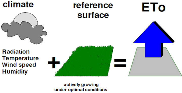
Figure 1. Reference evapotranspiration (ETo) by FAO.
loess plateau, and an important part of loess platform. The centre of Guanzhong Basin, North of Weihe River, and Weibei loess mesa is a unique landform of Loess Plateau in Northern China, which is also relatively short in water resources. Geological map of the study was presenting Figure 2. It is one of the biggest irrigation districts in Shaanxi and an important agricultural production area in China.
Xingping (latitude 34˚18'S, longitude 108˚28'E, altitude 408.0 m) and Wugong (latitude 34˚18'S, longitude 108˚04'E, altitude 505.0 m), which are located in the middle of central of Guanzhong Basin is the part of Baoyang irrigation area, occupied total areas 507.4 Km2, 397.8 Km2, and 292.81 Km2, 287.8 Km2 of cultivation area respectively. Climatically, this area belongs to continental monsoon climate, which is featured with four clear seasons with rains in spring and autumn, hot in summer and cold in winter.
During the study period 1981-2009, we found that the mean annual rainfall is 554.47 mm. Air temperature varies between; −2.1˚C (Min) and 28.6˚C (Max), mean relative humidity ranges from 48% (Min) to 90% (Max). The mean actual vapour pressure is 0.955 Kpa (Min) and 0.983 Kpa (Max), wind speed-above soil surface is 0.3 m/sec (Min) and 2.2 m/sec (Max) and the relative sunshine duration is 0.1 and 0.76 in Xingping district. Likewise, in Wugong county—the mean annual rainfall is 583.72 mm, air temperature varies between: −2.9˚C (Min) and 28.1˚C (Max), mean relative humidity is 45% (Min) and 89% (Max), mean actual vapour pressure is from 0.951 Kpa (Min) and 0.978 Kpa (Max), wind speedabove soil surface is 0.5 m/sec and 2.5 m/sec and the relative sunshine duration is 0.0 and 0.71.

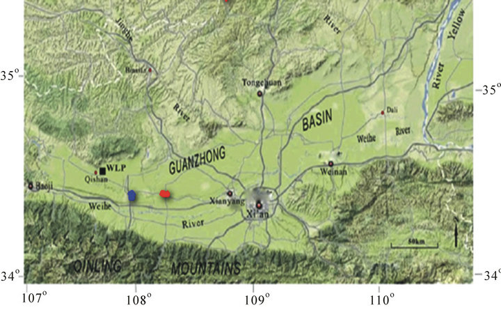
Figure 2. Illustrated the graphs of max, average, min, SD and skew of ETo (mm/day) of Xingping County from Table 3.
3. Materials and Method
Crop evapotranspiration (ETc) is a key factor to determine proper irrigation schedule and to improve water use efficiency in irrigated agriculture. ETc can be estimated by a reference crop evapotranspiration (ETo) and crop coefficient [6-9]. The reference evapotranspiration “ETo” can be estimated by many methods [10-12]. Methods range from the complex energy balance equations [13] to simpler equations that require limited meteorological data [14]. According to [5], the Penman-Monteith method gives more consistently accurate “ETo” than other methods. In addition, [15] after applying it in the Muda Irrigation Scheme in northwest Malaysia recommended this method. Therefore, in this study the reference evapotranspiration was estimated using PenmanMonteith equation. The calculation procedures allow for estimation of ETo using FAO Penman-Monteith method under all circumstances, even in the case of missing climatic data.
For the study, the Food and Agriculture Organization (FAO) Penman-Monteith methodology was used to determine the reference evapotranspiration (ETo) for the two stations (Xingping and Wugong) as it allows for the potential to alter ETc estimates for different crop types in the center of a large arid and sub-humid area Figure 1. Moreover, where, irrigation makes possible an intensive agricultural production. To carry out the reference evapotranspiration “ETo” in the area, the meteorological data of two stations have been selected within the region. With record monthly data, ranging from 1981 to 2009 years in length Table 1, this period was chosen preliminary to develop groundwater of the area as the part of study plan of Numerical simulation of groundwater. Thus, the study aims to establish the underlying best model result of reference evapotranspiration to lead that to estimate crop water requirements, which in turn leads for study water balance of the area. No interruptions and missing data find through the period.
3.1. FAO-56 PM Method
The FAO Penman-Monteith method for calculating the reference crop evapotranspiration is the adopted standard for this calculation [1]. In this paper, the result of “ETo” was compared between two stations of record throughout of 29 years. Evapotranspiration and rainfall are the two major components of the water balance and required accurate estimates to close the water balance of the area and the important components in the water cycle, which represents the water consumption by the plants and evaporation from the water and the non-vegetated surfaces. Reliable estimates of the total evapotranspiration from the wetland are useful information both for understanding the hydrological process and for water management to protect natural environment.

Table 1. Shows the type, period and length of data.
3.2. Calculation Method
The reference evapotranspiration (ETo) from meteorological data is assessed in the ETo calculator Software by means of the FAO Penman-Monteith equation. This method has been selected by FAO as the reference because it closely approximates grass “ETo” at the location evaluated is physically based, and explicitly incorporates both physiological and aerodynamic parameters. The relatively accurate and consistent performance of the Penman-Monteith approach in both arid and humid climates has been indicated in both the Area Study Centre for Europe (ASCE) and European studies. The FAO Penman-Monteith equation [1] is given by:
 (1)
(1)
where  reference evapotranspiration
 ,
,  net radiation at the crop surface
 ,
,
 soil heat flux density
 ,
,
 average temperature
 ,
,
 wind speed at 2 m height
 ,
,
 saturation vapour pressure
 ,
,
 actual vapour pressure
 ,
,
 saturation vapour pressure deficit
 ,
,
 slope vapour pressure curve
 ,
,
 psychrometric constant
 .
.
The value 0.408 converts the net radiation Rn expressed in MJ/m2·day to equivalent evaporation expressed in mm/day. Because soil heat flux is small compared to Rn, particularly when the surface is covered by vegetation and calculation time steps are 24 hours or longer, the estimation of G is ignored in the  calculator and assumed to be zero. This corresponds with the assumptions reported in the FAO Irrigation and Drainage Paper No. 56 for daily and 10-daily periods [13]. State that the soil heat fluxes beneath the grass reference surface is relatively small for that time period.
Psychrometric constant : The psychrometric constant in the Penman and Penman-Monteith (PM) equations is calculated as following [16]:
 (2)
(2)
where  psychrometric constant
 ,
,
 mean atmospheric pressure
 ,
,
 latent heat of vaporization, 2.45
 ,
,
 specific heat at constant pressure, 1.013 × 10⁻³
 ,
, ![]() ratio molecular weight of water vapour/dry air = 0.622.
ratio molecular weight of water vapour/dry air = 0.622.
The value of the latent heat varies as a function of temperature. As λ varies only slightly over normal temperature ranges, a single value of 2.45  is considered in the program. This corresponds with the calculation procedure for the FAO Penman-Monteith equation. The fixed value for λ is the latent heat for an air temperature of about 20˚C.
The Saturation vapour pressure as a function of air temperature  is calculated from Equation (3) [1,17].
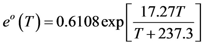 (3)
(3)
Slope of saturation vapour pressure curve : To calculate the reference evapotranspiration, the slope of the relationship between saturation vapour pressure and temperature, ∆, is required [1]. Give the slope of the curve at a given temperature.
 (4)
(4)
where  slope of saturation vapour pressure curve at air temperature T
 ,
,  average air temperature
 .
.
For RHmean, analysis with several climatic data sets proved that more accurate estimates of ea could be obtained with [5]:
 (5)
(5)
Net radiation : Net radiation
  was calculated based on the FAO expert panel methodology [2] which has been considered a standard in other studies [17,18].
  is calculated by subtracting the net incoming short-wave radiation
  from the net outgoing longwave radiation
  as summarized in Equation (6).
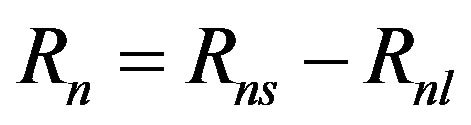 (6)
(6)
Solar radiation (Rs): If the solar radiation, Rs, is not measured, it can be calculated with the Angstrom formula, which relates solar radiation to extraterrestrial radiation and relative sunshine duration:
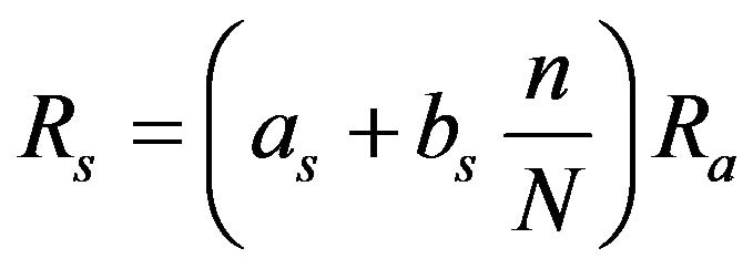 (7)
(7)
where  solar or shortwave radiation
 ,
, ![]() actual duration of sunshine [hour],
actual duration of sunshine [hour],  maximum possible duration of sunshine or daylight hours [hour], n/N-relative sunshine duration [-],
 extraterrestrial radiation
 ,
,  regression constant, expressing the fraction of extraterrestrial radiation reaching the earth on overcast days
 ,
,  fraction of extraterrestrial radiation reaching the earth on clear days
 . The default values for
  and
and  are 0.25 and 0.50. If the user has site specific information, calibrated values for
  and
and  can be specified in the Data and
  menu (Calculation method and coefficients).
4. Results and Discussion
As you, know this study just as primary for entering to develop groundwater of the area as the part of study plan of Numerical simulation of groundwater in this area, so we only have these results such as following:
By relating the measured of meteorological information from the study area to estimate reference crop evapotranspiration, the mean monthly rate of reference evapotranspiration was calculated employing the Penman-Monteith equation according to FAO-56 [19].
The reference evapotranspiration was calculated based on the data taken from the Xing ping and Wugong stations, taking into account the mean monthly values of the parameters involved in the above equations, for the period 1981-2009 (i.e., 29 years).
Table 2 shows that the annual (Maximum, Minimum, Mean, Skew, SD and Variations) of reference evapotranspiration of two stations—Xingping & Wugong—valued by FAO Method(s) and developed the ETO software for the study area. The results indicated that the annuallyvalues approximately closed throughout the period for two stations. The maximum values occurred in 1995 and 1997.
4.1. Monthly Average  for the Study Area
Tables 3, 4 and Figures 3, 4 illustrated the monthly values (i.e. Maximum, Mean, Minimum, SD and Skew) of reference evapotranspiration in Xingping County and Wugong County respectively. The results found that the values of  in Xingping and Wugong; ranged between 0.4 - 6.9 mm/day, 0.4 - 6.7 mm/day, and the average values are 2.6 mm/ day, 2.6 mm/day respectively. The amount of reference evapotranspiration approximately the same values at both stations. The monthly values of the reference evapotranspiration in (May, June, July and August) occurred as the maximum values that

Figure 3. Illustrated the graphs of max, average, min, SD and skew of ETo (mm/day) of Xingping County from Table 3.
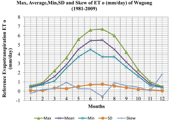
Figure 4. Illustrated the graphs of max, average, min, SD and skew of ETo (mm/day) of Wugong County from Table 4.
are refer to the maximum mean temperature for those months Figures 3 and 4.
We did the simple calibration used simple as the regression analyses between two stations Figure 5. The relation of reference evapotranspiration  between two stations (Xingping & Wugong) are very closing from the result the correlation coefficient
 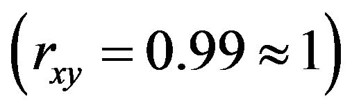 i.e.
i.e.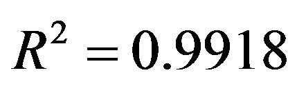 , and
, and .
.
4.2. Daily, Monthly and Annul Mean Values of 
The daily values for every month through the time period (i.e. 1981-2009) were presented in Tables 5 and 6, as the model (software) results. Obviously, the maximum values of  were occurred in may, June, July and August due to the highly temperature of those months. Figure 6 presents the mean annual reference evapotranspiration values estimated by The FAO Penman-Monteith method for the study area. The three straight lines refer to the average values of the
  the upper line explain the mean value of Wugong and the lower explain the values of Xingping, while the middle is the average values from both. From the trend line, the values of both stations, even the mean were indicating that the “
 ” was increasing by recent years if exclude the first two years and the middle years of the length (1994 to 1997).
4.3. The Estimation of Crop Evapotranspiration 
This simple model can be used for the study area to reasonably estimate reference crop evapotranspiration in our study. Evapotranspiration rates vary between plant species and also vary for different times of the year and different stages of plant growth. To account of these variations the reference evapotranspiration  is multiplied by a crop factor
  to give a particular crop evapotranspiration
  as shown in Equation (4.1)
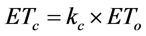 (4.1)
(4.1)
where: 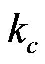 is the single crop coefficient, which averages crop transpiration and soil evaporation.
The crop factors  have been determined by field experiments, and have been compiled and are provided for most crops by the FAO. As these are generalized, crop factors developed specifically for the study area were developed in 1991 by Xiaoling Su from Northwest Agricultural and Forestry University. Crop factors used in the study were compared to those available from the FAO, The length of growing season and crop factor were comparable and as shown in Figure 7.
The average monthly reference crop evapotranspiration  for winter wheat, maize, rice/cotton and rapeseed crops in Xingping and Wugong for the irrigation period were presented in Table 7. Since this area is hot in summer and cold in winter and the different stage of crops, as the results, that the value of the reference crop evapotranspiration are increasing from January to May, and the maximum values are occurred between Jun to August, then start to decrease from September to December.
5. Conclusion
The calculation procedures in this paper allow for estimation of  as a preliminary for entering to develop groundwater of the area as the part of study plan of Numerical simulation of groundwater in this basin ( Baoyang irrigation area) using FAO Penman-Monteith method under all circumstances. The paper compares the reference evapotranspiration of two Counties based on the data from the (North West A&F University). It can be concluded that the mean values of
  throughout the period (1981-2009) in Xingping and Wugong, ranging

Table 2. Presents the annual parameters for two stations.
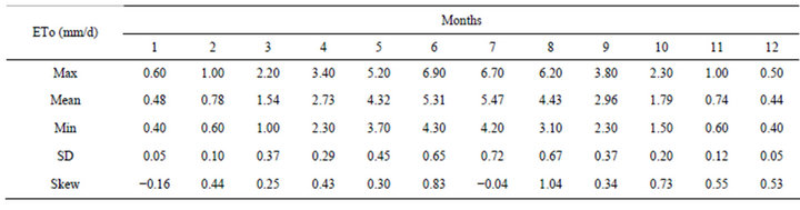
Table 3. Xingping (China)—monthly values: January 1981-December 2009, average  (mm/day).

Table 4. Wugong (China)—monthly values: January 1981-December 2009, average  (mm/day).

Table 5. Xingping (China)—monthly results: average  (mm/day) January 1981-December 2009.

Table 6. Wugong (China)—monthly results: average  (mm/day) January 1981-December 2009.
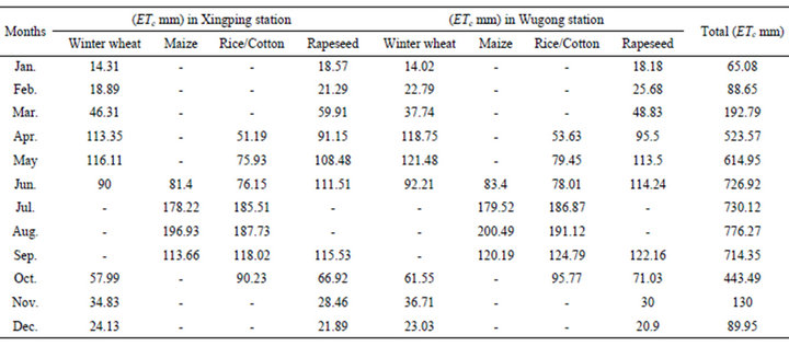
Table 7. Presents the total ETc in mm for winter wheat, maize, rice/cotton and rapeseed crops in Xingping and Wugong.
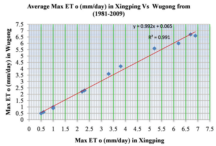
Figure 5. The relationship of Maximum ETo from Xing ping and Wu gong. X-axis illustrated the ETo in Xing ping, while Y-axis illustrated ETo of Wugong station.

Figure 6. The mean annual reference evapotranspiration.

Figure 7. Crop factors for different seasons and crops.
between 0.4 - 6.9 mm∙day−1, 0.4 - 6.7 mm∙day−1 and the average value is 2.6 mm∙day−1, 2.6 mm∙day−1 respectively. The maximum values are occurred in summer season (May, June and July). The annually values of ETo occurred in 1995 and 1997 as the higher one, that are refer to the maximum mean temperature for those months (i.e. the temperature is most sensitive parameters in this study). The correlation coefficient is very high . The daily values for every month through the time period (i.e. 1981-2009) were presented in Tables 5 and 6. The results of both stations were indicating that the “
 ” was increasing by recent years. The average monthly reference crop evapotranspiration
  for winter wheat, maize, rice/cotton and rapeseed crops in Xingping and Wugong for the irrigation period were presented in Table 7.
6. Acknowledgements
For data sources, we thank the Shaanxi office of meteorological information through Northwest A&F University. We also wish to express our appreciation to Agronomy journal reviewers for their valuable comments and suggestions concerning this manuscript.
REFERENCES
- R. G. Allen, L. S. Pereira, D. Raes and M. Smith, “Crop Evapotranspiration—Guidelines for Computing Crop Water Requirements,” FAO—Food and Agriculture Organization of the United Nations, Rome, 1998.
- I. A. Walter, R. G. Allen, R. Elliott, B. Mecham, M. E. Jensen, et al., “ASCE’s Standardized Reference Evapotranspiration Equation,” In: R. G. Evans, B. L. Benham, T. P. Trooien, Eds., Proceedings of National Irrigation Symposium, ASAE, Phoenix, 2000, pp. 209-215.
- P. Droogers and R. G. Allen, “Estimating Reference Evapotranspiration under Inaccurate Data Conditions,” Irrigation and Drainage Systems, Vol. 16, No. 1, 2002, pp. 33-45.
- K. R. Karanth, “Studies in Hydrologic Parameters of Ground Water Recharge in Water Balance Computations in Andra Pradesh,” Hydrology Review, Vol. 4, No. 1-4, 1978, p. 65.
- M. Smith, R. Allen, J. L. Monteith, A. Perrier, L. Santos Pereira and A. Sageren, “Expert Consultation on Revision of FAO Methodologies for Crop Water Requirements,” Food and Agricultural Organization of the United Nations, Land and Water Development Division, Rome, 1992, p. 60.
- J. Doorenbose and W. O. Pruitt, “Guideline for predicting crop water requirements,” FAO Irrigation and Drainage, Rome, 1977, p. 193.
- S. Z. Kang, “Calculation and Prediction of Actual Winter Wheat Evapotranspiration in Condition of Soil Water Deficit (in Chinese),” Acta Unic. Agric. Boreali-Occidentalis, Vol. 14, No. 1, 1986, pp. 93-102.
- S. Z. Kang, Z. Z. He and X. Zhang, “Crop Water Requirement and Irrigation Models in Shaanxi Province,” Chinese Hydraulic and Hydropower Press, Beijing, 1992, p. 2.
- G. Kerr, L. Pochop, K. J. Fornstrom, J. M. Krall and D. Brown, “Soil Water and ET Estimates for a Wide Range of Rainfed and Irrigated Conditions,” Agricultural Water Management, Vol. 24, No. 2, 1993, pp. 147-159. doi:10.1016/0378-3774(93)90005-U
- M. E. Jensen, “Consumptive Use of Water and Irrigation Water Requirements: A Report,” American Society of Civil Engineers, New York, 1974.
- R. W. Hill, R. J. Hanks and J. L. Wright, “Crop Yield Models Adapted to Irrigation Scheduling,” Utah State University, Logan, 1985, p. 198.
- S. Z. Kang, X. M. Liu and Y. Z. Xiong, “Theory of Water Transport in Soil-Plant-Atmosphere Continuum and Its Application,” Chinese Hydraulic and Hydro-Power Press, Beijing, 1994, p. 228.
- R. G. Allen, M. E. Jensen, J. L. Wright and R. D. Burman, “Operational Estimates of Reference Evapotranspiration,” Agronomy Journal, Vol. 81, No. 4, 1989, pp. 650-662. doi:10.2134/agronj1989.00021962008100040019x
- G. H. Hargreaves and Z. A. Samani, “Reference Crop Evapotranspiration from Temperature,” Applied Engineering in Agriculture, Vol. 1, No. 2, 1985, pp. 96-99.
- Md. H. Ali, T. S. Lee, C. Y. Kwok and A. F. Eloubaidy, “Modelling Evaporation and Evapotranspiration under Temperature Change in Malaysia,” Pertanika Journal of Science and Technology, Vol. 8, No. 2, 2000, pp. 191- 204.
- D. Brunt, “Physical and Dynamical Meteorology,” 2nd Edition, University Press, Cambridge, 1952, p. 428.
- R. B. Grayson, R. M. Argent, R. J. Nathan, et al., “Hydrological Recipes, Estimation Techniques in Australian Hydrology,” Cooperative Research Center for Catchment Hydrology, 1996.
- J. F. Costello, A. Shields, R. B. Grayson and T. M. McMahon, “Determining Loss Characteristics of Arid Zone River Water Bodies,” River Research and Applications, Vol. 23, No. 7, 2007, pp. 715-731. doi:10.1002/rra.991
- FAO, “ETo Calculator. Land and Water Digital Media Series No. 36,” FAO, Rome, 2009.
NOTES
*Corresponding author.